A lot of history has come and gone from North Omaha. Starting in the 1860s, one neighborhood would in-fill and its main building boom was done, while another would begin brand-new, taking over a cornfield or wilderness with houses, streets and people springing up in nature’s place. One of these developments was called Monmouth Park.
Beginning Monmouth Park

There is a town in Wales called Monmouth; the Monmouth Park neighborhood might have been named after it. A New Jersey horse track called Monmouth Park was opened in the 1870s, and Omaha’s neighborhood might have been named for it, too. Established in the 1880s, there is no actual park called Monmouth Park. However, there is a lot of history in the neighborhood.
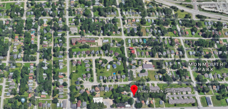
Located from North 33rd to North 36th, the neighborhood extended from Ames Avenue to the old Chicago, St. Paul, Minneapolis and Omaha Railway, aka the Omaha Road, which ran along the present-day Sorenson Parkway. There are hundreds of homes within the area today. Monmouth Park neighborhood is bounded by the Collier Place, Druid Hill and Central Park neighborhoods. The neighborhood does not show on an 1883 neighborhood map of Omaha; however, Collier Place and Tuttle’s Addition neighborhoods do, and they were located east and west of Monmouth Park, respectively. Monmouth Park was on the map by 1887 though.
One book said that between the time the neighborhood formally opened for development in 1886 to a year after, Monmouth Park had “as many houses and barns had been erected as to make a showing like a new village on the east hillside.”

Some of the homes in the Monmouth Park neighborhood right now were built in the 1880s. Others were built right around 1900 as in-fill houses, smaller workers’ houses with traditional features including gable roofs and wide front porches. A few buildings and homes in the neighborhood were built in the 1920s and 1930s for Immanuel students and staff, and many others were built by nonprofit organizations in the 1990s and 2000s as low-income housing developments.
A big influence in the development of Monmouth Park was the electric streetcar, which started running from North 30th to North 36th Street by 1891. Along with the Belt Line Railway built less than a mile away just two years earlier, these transportation systems allowed Monmouth Park residents to travel from downtown and other parts of the city back home, and the neighborhood was more attractive because of that. This same stretch was paved with bricks by 1900. Almost 20 years later, in 1907, the streetcar line was extended along Ames Avenue, up North 40th and over to North 42nd and Grand Avenue, the heart of the Central Park neighborhood. This section wasn’t paved until 1923.
According to estimates from the Nebraska Telephone Company, the neighborhood had a population of 2,996 in 1917. By 1933, it had almost 100% population growth with 5,980 residents.
Seen strictly as a suburb into the 1910s, the Monmouth Park neighborhood wasn’t fully surrounded by the city until the post-WWII building boom of the 1940s and 1950s. It was 1923 when Omaha North High School was built across the street from the neighborhood, leading students from neighborhoods across the city through the neighborhood and bringing families into the homes there, too.

In the 1950s, Ames Avenue became a popular cruising strip for students from North High School. Businesses popped up along the strip to serve them, including
Monmouth Park School


Starting from a small four-room wooden schoolhouse opened in the 1880s, Monmouth Park School left an indelible mark on the neighborhood. After it got a new building, from 1903 to 1983 the northwest corner of North 33rd and Ames Avenue acted like a beacon for students in the Monmouth Park neighborhood. Designed by popular Omaha architect Thomas Rogers Kimball, the Monmouth Park School hosted kindergarten through eighth graders, graduating students until the 1920s when North High was opened nearby.
It was the first school building in Omaha to act as a community center. The school district was bombarded by requests from the neighborhood to keep the building open for neighborhood members after school and on the weekend, and the school board allowed the use. By 1921, the practice had expanded citywide and was seen as a popular approach.


The school became one of Omaha’s defacto segregated schools in the 1960s, which were the few schools where the city’s African American students attended. Faced with budget cuts in 1980, the Omaha Public Schools proposed merging the student body into the nearby Druid Hill Elementary and closing the building. In 1982, the building was closed. After an outcry from preservationists because of its historical pedigree, district officials canceled the demolition of the building and sold it to private investors.
The building was converted into apartments, but suffered from low interest. After a wind storm caused severe damage to the building in 1993, it was demolished in 1995.
Monmouth Park Methodist Church

As the neighborhood grew, it attracted a variety of churches. One was the Monmouth Park Episcopal Church, started by Rev. William B. Slaughter in the spring of 1888. The first church was built at North 34th and Larimore Streets in 1889. The little church served an influx of new residents from the surrounding neighborhoods, and after just a few years a new church was needed to seat all the members. Rev. F. W. Bross was the longtime minister at the church.
In May 1902, the church was completely obliterated by a tornado. Contemporary newspaper reports said, “…there is something in the misfortune growing out of even a miniature cyclone that commands popular sympathy.” Church members rebuilt their building by July 1902.
In 1929, the church was renamed and opened a new building at 4023 Ames Avenue, and was called by a new name, the Ames Avenue Methodist Episcopal Church.
Immanuel Deaconess Institute and Immanuel Hospital

Perhaps the most important institution to open in Monmouth Park was the Immanuel Deaconess Institute, which was established in 1889 by the Lutheran Church. Many of the early buildings here were designed by prolific Omaha architect John Latenser. Home to a nurses’ college, orphanage, senior living facility and more, its most famous arm was the Immanuel Hospital.
Built with ambition, the institute seemed to constantly expand over the years. In the course of time, it grew from a few houses and the single hospital building to more than a dozen buildings over six blocks in the neighborhood.
Citing growing concerns over their facilities, the Immanuel Deaconess Institute spun off their senior citizens home, nursing school and other wings until 1976, when the entire Monmouth Park facility was closed permanently and the hospital was moved to North 72nd and Sorenson Parkway, where it continues functioning today. There are three buildings left from the original institute. Learn more from my article, “A History of Immanuel Deaconess Institute and Immanuel Hospital.”
Monmouth Park Today
Today, the Monmouth Park neighborhood might have the highest percentage of new housing in North Omaha. In-filled with a variety of developments, the neighborhood was targeted extensively by nonprofit housing organizations from 1990 through 2000.
Unfortunately, most of the commercial enterprises in the neighborhood are gone now, along with many of the faith communities once located there.
There are no historic markers in the Monmouth Park neighborhood, and none of the homes are recognized as official Omaha Landmarks by the City of Omaha Landmark Heritage Commission or listed on the National Register of Historic Places.
You Might Like…
MY ARTICLES RELATED TO THE HISTORY OF AMES AVENUE
NEIGHBORHOODS: Saratoga | Collier Place | Monmouth Park | Prairie Park
INTERSECTIONS: 30th and Ames | 40th and Ames | 24th Street | North Freeway | Fontenelle Boulevard
BUSINESSES: LaRue’s | Max I. Walker | North Star Theater aka Ames Theater | King Solomon’s Mines aka Shaver’s | Beacon Theater | Parkside Cafe | Ames Plaza | Battiato’s Super Market | Mergen House
PUBLIC PLACES: Ames Avenue Bridge | Saratoga School | Charles Washington Branch Library | Monmouth Park School | North High School | Fontenelle Park
OTHER: Druid Hall | St. Vincent’s Retirement Home | Ames Avenue United Methodist Church | Mergen House
MY ARTICLES ABOUT HISTORIC NEIGHBORHOODS IN NORTH OMAHA
National Register of Historic Places Historic Districts in North Omaha: 24th and Lake Historic District | Benson Downtown Historic District | Country Club Historic District | Dundee/Happy Hollow Historic District | Fairacres Historic District | Fort Omaha Historic District | Minne Lusa Historic District | Nicholas Street Historic District
Historic Neighborhoods in North Omaha: Bedford Place | Belvedere Point | Bemis Park | Benson | Briggs | Bungalow City | Carter Lake, Iowa | Central Park | Clifton Hill | Collier Place | Creighton University | Crown Point | DeBolt | Druid Hill | East Omaha | Fairfax | Florence | Florence Field | Fort Omaha | Fontenelle View | Gifford Park | Gold Coast (Cathedral) | High Point | Jefferson Square | Kellom Heights | Kountze Place | Lakewood Gardens | Little Russia | Long School | Malcolm X Memorial | Miller Park | Miller Park Duplex Historic District | Monmouth Park | Montclair | Near North Side | North Downtown Omaha | Omaha View | Orchard Hill | Plum Nelly | Prairie Park | Prettiest Mile in Omaha | Prospect Place | Raven Oaks | Redman | Saratoga | Sherman | Squatter’s Row | Sulphur Springs | Ponca Hills | Wakonda | Walnut Hill | Winspear Triangle | Wyman Heights
Lost Towns in North Omaha: Benson | Briggs | Cutler’s Park | DeBolt | East Omaha | Florence | Saratoga | Sulphur Springs | Winter Quarters

Elsewhere Online
- “Monmouth Park Infill Housing,” Michael Leonard Architect webpage
BONUS PICS!


Leave a Reply