At the end of the 19th century, North Omaha was the place to live in Omaha. Because of that, the City of Omaha invested big money improving the community. In the 1880s, new gas lamps lit the major streets; old horse-drawn streetcars were replaced by new electric versions; and large North Omaha streets got their first paving of gravel, wood, and stone. However, one of the largest investments was the creation of extravagant roadways that wound across the terrain and meandered through undeveloped areas. These were relatively high-speed routes though, and many people saw them as ideal for strolling in their horse-drawn wagons and buggies. This is a history of Boulevards in North Omaha.
Cleveland in Omaha

After being founded in 1854, the City of Omaha took 25 years to establish its first parks commission. Led by Dr. George Miller, the first commission in the 1880s sought to beautify Omaha with original thinking that was current in those times. They looked to the national Garden Beautiful movement for inspiration, and hired an East Coast figure to show them the way.
The original boulevard system in Omaha was designed by nationally-known planner named Horace W.S. Cleveland. It was 1889 when he proposed to the Omaha City Council that they invest in a system of parks and boulevards throughout the city, which was then approaching its 35th anniversary. Anxious to compete with other Midwest cities and to keep up with the Eastern cities its founders migrated from, the City Council contracted with Cleveland to design the new system.
Cleveland planned broad views, curving roadways, and pleasing features like lagoons and tree groves lining 20 miles of boulevards. The original route connected with 12 parks throughout the entire city. Some of the parks connected by boulevards in North Omaha include Miller Park, Kountze Park, Fontenelle Park, Bluff View Park, Adams Park, and Bemis Park, with others along the way. Cleveland’s plans from the 1890s guided City planning for the next several decades afterward.
Prettiest Mile In Omaha Boulevard

The first outcome of Cleveland’s plan was called “The Prettiest Mile in Omaha Boulevard,” and ran north of Ames Avenue. The strip was home to several mansions * * and two new developments overlooking the Missouri River valley, and abutted the then-new Miller Park. Called Florence Boulevard, it was named for the small town adjacent to Omaha called Florence, which today is a neighborhood at the north end of the city. With several fine homes built along the way * * * * *, the early investment by the City became instantly popular. The boulevard was eventually extended, and today runs from Cass Street in North Downtown to Read Street and JJ Pershing Drive. There are several notable homes and buildings along the entirety of the boulevard today * * *.
Wrapping Around Omaha
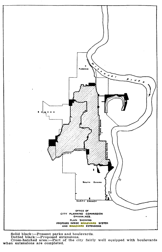
After Florence Boulevard was started, Omaha built more in other parts of the city. Traveling through western and southern neighborhoods, eventually the boulevard system formed a belt around the city, echoing the earlier-devised Beltline Railway. Used as a real estate development tool from its start through the 1950s, there were several new North Omaha neighborhoods that were built out quickly because of a boulevard in the system. They included:
- Lincoln Boulevard skirting the Montclare neighborhood around North 30th and Cuming Street and jutting through the Bemis Park neighborhood;
- the Fontenelle Boulevard connecting Clifton Hills, Waverly Park, and Clairmont Heights additions with Fontenelle View, Central Park, Crown Point, and Florence Field neighborhoods;
- John A. Creighton Boulevard, which served as a thread tying together many neighborhoods, including Bedford Place, Adams Park, Erskine Park, Franklin, Orchard Hill, Omaha View, and Prospect Hill, and;
- Paxton Boulevard connects the Bedford Place neighborhood to the Fontenelle Park, and ties together the John A. Creighton Boulevard to the Fontenelle Boulevard.
While it was the intent was to establish a useful traffic loop around an older core of Omaha, there were several smaller boulevards built through specific neighborhoods, including:
- Minne Lusa Boulevard, which connected its neighborhood to the fine Miller Park and J.J. Pershing Drive;
- Belevedre Boulevard, which wiggles from the Belevedre Point to the Miller Park;
- Carter Boulevard, also called Horseshoe Bend, simply moving traffic from Saratoga through the Bluff View Park into East Omaha;
- Cornish Boulevard, which only acts as a connector from North 16th Street and Boyd Park to the Carter Lake Shore Drive;
- Similarly, Mercer Boulevard is just a single block connector from Nicholas to Cuming Street, connecting the once-beautiful Walnut Hill Reservoir to the Mercer Park Road and Lincoln Boulevard.
However, by the 1920s, public leaders’ acceptance of the primary role of the boulevard system to efficiently and effectively move cars around Omaha was vacillating. Instead, they began to dream of bigger roadways that had higher capacities for more cars to move more quickly.
Leaving Omaha’s Boulevards Behind

There are several other pretty drives throughout North Omaha that could’ve been considered parts of the City’s boulevard system, but weren’t. Throughout the decades, the City wavered on its commitments to the system. As part of the Works Progress Administration (WPA) of the 1930s, Omaha used the Civilian Conservation Corps and federal dollars to reconstruct and upgrade its boulevard system. Adding more than 30 miles onto the existing system of 65 miles, the WPA completed work on the Saddle Creek Underpass connecting emerging west Omaha neighborhoods both north and south of Dodge Street. Originally called the Saddle Creek Boulevard, today the Saddle Creek Road and its historic underpass are well-maintained.
The presence of the boulevard system continued to be a boon to real estate in North Omaha into the 1930s. However, with the end of World War II and new home loans for veterans, the system was almost wholly abandoned. By the 1950s, the city, state, and federal governments were committed to building high-speed interstates throughout Omaha. Intended to entirely replace the convenience of the meandering boulevards, these behemoths also obliterated several routes in the city’s boulevard system. In the meantime, new sections of the city were built without boulevards, and other areas that could’ve relied on boulevards were cut-off from them or discouraged from using them efficiently. These included suburban tracts in North Omaha, as well as new sections of the city beyond North 60th Street.
Streets north of Dodge and east of 72nd that could have been additions to the boulevard system include:
- The Underwood Avenue through the Fairhaven neighborhood;
- Fairwood Lane and Hillcrest Drive in the Memorial Park neighborhood;
- Lake Shore Drive through Levi Carter Park;
- Country Club Road by the Omaha Country Club;
- the Mormon Bridge Road;
- Northwest Drive by Fontenelle Elementary School;
- the remainder of Martin Avenue in the Florence Field neighborhood;
- the North Ridge Drive in Florence;
- the Florence Heights Boulevard in Florence, and;
- JJ Pershing Drive, which was originally planned as the city-long River Drive.
Each of these were all non-starters for the boulevard system. Each of these streets that were built to echo the system but weren’t integrated into it, and the usage of the entire system was displaced by urban planning that was neither committed to a successful inner-city core or maintaining the value of historic neighborhoods, including their parks, homes, and other facilities.

Instead of using boulevards further, the City and State government developed “traffic axes” to divide, segregate, and otherwise eliminate the vitality of North Omaha’s boulevard system. In the 1950s roadways including Military Avenue and the Radial Highway were developed into higher speed expressways to shuttle traffic through North Omaha neighborhoods without regard for the commercial corridors along those routes. In the 1960s, the North Freeway was planned in order to segregate North Omaha’s predominantly African American neighborhoods by effectively cutting the residential, commercial, and social ties that bound together a 10-square mile area. Even in the 1990s, the City of Omaha continued to develop new traffic axes, this time in the form of Sorenson Parkway and the Abbott Connector as high speed routes that move cars from west Omaha towards the airport with no regard, interaction, or positive impacts on the neighborhoods along the routes.
Omaha neglected the boulevard system for the next 50 years. Entire sections were integrated into the regular grid street sections and the elegance, convenience, and simplicity of these beautiful parkways was forgotten. Many historic sections of North Omaha’s boulevard system didn’t fare so well.
However, in the 2010s something happened.
Boulevards in North Omaha Today

Today, the boulevards in North Omaha include Belvedere Boulevard, Florence Boulevard, Fontenelle Boulevard, John A. Creighton Boulevard, Lincoln Boulevard, Minne Lusa Boulevard, Paxton Boulevard, Mercer Boulevard, and Carter Boulevard.
Horace Cleveland’s boulevard plan for Omaha has never been completely realized. As this article details, there were a lot of other forgotten, neglected, and denied dreams for the boulevard system. There were even traffic axes used to kill them. The entire system is still plagued by poorly maintained landscaping, poorly maintained pavement, poorly lit and non-upgraded lighting and bad intersections plague many parts of the system, including Florence Boulevard, Paxton Boulevard, and others. Under-realized and missing features line the boulevard system today, including the Miller Park lagoon, the Kountze Park, the view from Bluff View Park, the entire J. A. Creighton Boulevard, Lincoln Boulevard, the entire section called “Omaha’s Most Beautiful Mile,” and Bemis Park, among many others.
Something happened on the way to the market though! In the 2000s, a revitalization effort was led by organizations including Omaha By Design which led the City of Omaha to look closer at the boulevard system again. In 2013, the National Park System listed the Omaha Park and Boulevard System on the National Register of Historic Places in order to recognize its historical contributions to the city and its neighborhoods. Energy is regularly devoted by the City of Omaha Planning Department to improving the system, and various groups advocate for its continued renaissance.
Today, the boulevard system still forms a nice loop to circle around North Omaha and access other parts of the city, too. More should be done to preserve, maintain, sustain, and even expand it.
You Might Like…
- A History of Streets in North Omaha
- A History of Fontenelle Boulevard
- A History of the Florence Boulevard
- A History of North Omaha’s J.J. Pershing Drive
- History of the River Drive in Omaha
- A History of the Ponca Road
Elsewhere Online
- “There Must Be Boulevards“, a beautiful tour of Omaha’s entire boulevard system from Omaha By Design
- “Omaha Park and Boulevard System” from the City of Omaha Landmark Heritage Preservation Commission
- “Omaha Park and Boulevard System” from HistoricOmaha.com
Bonus Pics!



Leave a comment