
Adam’s Note: This article was written with research support from the Kiewit Corporation, which recently opened a training facility called the Kiewit University at 1561-1501 Burt Street in North Downtown Omaha.

Pioneers and prostitutes, capitalists and consumers packed one area of downtown Omaha for more than a century. Despite its redevelopment today, the North Downtown neighborhood has a long history. Its had many identities.
For the sake of keeping this article’s length reasonable, I will define North Downtown as the area between Cass and Cuming from North 10th to North 17th.The boundaries of Omaha and its communities and neighborhoods have been shifting since the city was founded. I found an 1867 article that mentioned North Omaha anything between Farnam and Cass! So, using these boundaries for North Downtown seems appropriate, especially since the City hasn’t said anything “official” about neighborhood boundaries, or declared North Downtown a Business Improvement District.
Following is a history of Omaha’s North Downtown.
The First Town Survey
The first people who lived in the region making up modern-day North Downtown Omaha were Woodland tribal groups who lived up and down the Missouri River before AD 1400. Around that point, the Otoe tribe had a village along a stream called North Omaha Creek that went through North Downtown into the river.
In 1854, a surveyor named Alfred D. Jones (1814-1902) was hired by the Nebraska Ferry Company to lay out a city including this area. The ferry company was essentially a real estate company that snatched up the Omaha area as soon as it became available for settling.
Jones became the preeminent pioneer settler of Omaha and was locally famous throughout the city’s early history. As a surveyor, he laid out Omaha City and named its first and most prominent streets. He was one of the first lawyers in Omaha, and served on the first Douglas County Commission and on the first Omaha City Council. He was the Speaker of the Nebraska Territory House of Representatives, and the first postmaster in Omaha. As a member of the second territorial legislature, he also named several counties across Nebraska. He helped found the Omaha Claim Club, and eventually, his law firm and land holdings made him rich and he retired wealthy.

In the map above, you can see the North Downtown area clearly platted. Created by A.D. Jones for the ferry company, its original caption (from the Durham Museum) says,
“Lots will be given to persons who will improve them, private sales will be made on the premises. A newspaper, the ”Omaha Arrow” is published weekly at this place a brick building suitable for the Territorial Legislature is in process of construction – and a steam mill and brick hotel will be completed in a few weeks.”—Sept 1st, 1854
Prominent geographic features include the Missouri River on the east; the North Omaha Creek weaving wily nily through the neighborhood, and the “Winter Quarters Road,” which became Florence Boulevard.
You’ll notice on the upper left corner of the map there are several streets marked that don’t exist today, including Swan, Eagle, Otter, Elk, Buffalo, Badger, and Antelope Streets. Of course, another map from the same era shows the same area with Canal Street, intersected by Bowery Street, Aspinwall Street and Bright Street, along with Blessington Street, none of which exist. So, there wasn’t 100% agreement on what the street names would become from the outset. However, most of that was settled for North Downtown by 1860. The streets in North Omaha are some of the oldest in Omaha, and as this map shows, North Downtown is home to several of those old streets.
According to Omaha’s historical lore, the first formal stake in Omaha was called the “Ferry Claim,” and was made in April 1854 when Jones took a line of string around the land and marking the corners by stakes. The northern line went from the Missouri River to “Swan Street,” which is called Cuming Street now, south to 13th and Webster, then to 23rd and Webster Streets straight through North Downtown. The original lots in the city, which were part of Jones’ survey of 1854, included all of the blocks between Webster and Cass, from 10th to 17th Streets. North Downtown is truly in one of the oldest parts of Omaha.
The First Players


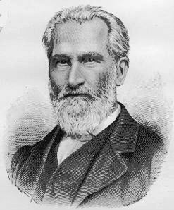
Above are images of (counter-clockwise) Dr. George Miller (1830–1920); Herman Kountze (1833-1906); “Doc” George Smith (1826-1901); Tom Cuming (1827-1858); and Judge George Lake (1827-1910).
Given that North Downtown was such a speculative place and a lot of people anticipated its value, there were a number of early players involved in the area.
Omaha pioneer Dr. George Miller moved to the neighborhood and started living there in 1854. Originally living in a shanty at 9th and Cuming, he moved to a cabin lent to him by Nebraska Territorial governor Thomas Cuming in 1855 that was located at present-day 24th and Cuming. According to a short history of his early life in Omaha, Miller said Cuming claimed the land to the southeast of his shack, including North Omaha Creek and the land surrounding it, which would’ve included the specific blocks you’re interested in. He became a very important city leader and wealthy man.
William Paxton was an early freighter in Omaha. He switched industries and started constructing bridges along the Military Road, including at least one over the North Omaha Creek, which flowed through your neighborhood, in 1857. He kept going west, building bridges along the road all the way to Kearney. Coming back to Omaha in 1860, he went on to become a city leader. T. W. T. Richards and L. G. Heybrook established the Cass Street Foundry in 1880. Paxton and Vierling Iron Works started after William Paxton bought the Cass Street Foundry in 1886, and after a fire they moved their factory south of downtown.
There were other important Omaha pioneers in the area too.
Developing the Area

The first development in North Downtown Omaha started at 10th and Cass and nearer to the river. Then, white settlers spread westward and northeastward.
At first, this area was referred to as North Omaha. Eventually it became known as the Near North Side, which served alternately as a euphemism for a segregated Black neighborhood in the area. Today, the area has been rebranded as North Downtown, and just like now, there were many landowners and speculators in this area at the beginning of the city’s life. It became important within a decade of the city’s founding.
The North Downtown area wasn’t part of the notorious land grab by Nebraska Territorial legislators called Scriptown, and despite its importance, sewers weren’t installed in North Downtown until 1881, more than 25 years after Omaha was founded.
Some of the important early developments in this area included streets, bridges and schools. For instance, Cass School was opened at 1418 Cass Street in the 1870s. Lucinda Gamble, one of Omaha’s first African American teachers, taught there from 1895-1899. The first Catholic school in Omaha was located at the intersection of N. 18th and Cass Streets, and was called St. Catherine’s Academy.
California Street was named for the ’49ers who came this route on their way to California, landing at the base of the street when they crossed the Missouri River. It was originally the most important street in North Downtown. California Street was the original route of Military Road, and it was laid out from the river to Fremont by 1858. It remained that way until 1873, when the City Council decommissioned Military Road to what was then regarded as “west Omaha,” just past North 45th Street. The City of Omaha removed the “highway” designation from downtown through the Orchard Hill neighborhood and changed its name and identity forever.
The neighborhood’s Burt Street was named for the first governor of the Nebraska Territory, Francis Burt, who died 10 days into his term. Similarly, Cuming Street was named for Thomas Cuming, the second governor of the territory. Cuming Street was the northern Omaha city limit until about 1872.

Diversity Abounded

Today’s North Downtown neighborhood was historically home to a lot of ethnic, cultural and social diversity.
African Americans
The neighborhood between North 15th and North 19th from Webster to Cuming was one of the first racially segregated neighborhoods in Omaha. The first and oldest African American church in Omaha, St. John’s AME Church, was at 617 North 18th Street, and two Black hotels were located in the area: the Warden Hotel at 817 North 16th Street, along with the Booker T. Washington Hotel at 1719 Cuming Street.
The hugely important and severely under-acknowledged Near North Side neighborhood runs from Cuming on the south to Locust Street on the north, and from North 14th on the east to 30th Street on the west. It is where a lot of Omaha grew up, including working class European immigrants, Omaha’s Jewish community, and for the last 80 years its served as the core of Omaha’s African American community. The historical home of the Logan Fontenelle Public Housing Projects, the area was the target of federal “slum clearance” programs in the 1930s before they were built. Demolished in the 1990s, today this area is being rehabilitated.
Chinese
A large population of Irish people lived in today’s North Downtown area from the 1880s through the 1920s. There was enough of a population there for Omaha’s Catholic archdiocese to appoint an Irish priest to serve them at Holy Family Church at nearby North 17th and Izard Street during that era.
Starting in the late 1930s, there was a significant Chinese community in today’s present-day North Downtown neighborhood around North 17th and Cass Streets. Distinct from the Chinatown at 12th and Dodge, this neighborhood covered a few blocks. The Lee Kune Chinese Laundry was at 1610 Cass Street, and the Lee Moy Chinese Laundry was at 1514 Webster Street. Soon Lee, a leader among the Chinese American community, lived at 1617 Cass Street, while 1609 Cass St was the home of Sam Huey. The Chin family lived at North 16th and Burt Street, until Jimmy Chin moved his family to 19th and Burt streets. According to a 1961 feature in the Omaha World-Herald, “For many years On Leong activities were centered in a white-brick building on Cass Street between Fifteenth and Sixteenth Streets.” The On Leong are an ethnic minority among the Chinese. The building still stood when the article was written, and was described as a two-story building with Chinese lettering across the top. Its second location in Omaha, the building was closed in the 1950s when the last member died.
Irish and Italians
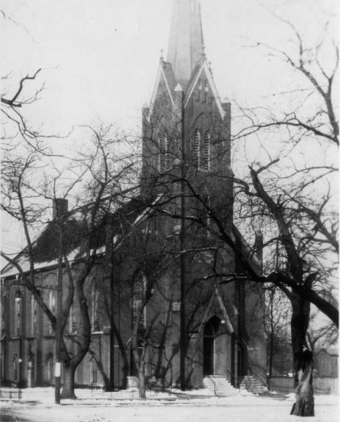
After the Irish integrated into Omaha’s white population, the Holy Family Church became Italian, and North Downtown had a significant Italian population for a period of time, too. Rev. J. J. Faso, an Italian-born priest, succeeded Rev. Patrick Cooney at the church in 1937 because of the growing Italian immigrant population in the neighborhood. Holy Family remained an Italian parish until 1967, when it was declared a mixed parish for anyone across the city.
Scandinavians
Omaha’s Little Stockholm neighborhood was located immediately to the west of North Downtown, with the center of their community being at several churches from 18th to 24th Streets. Bordering North Downtown was the North Omaha Bottoms area, which extended from Cuming Street to Locust Street east of North 16th and North 9th Streets.
Other Diversity
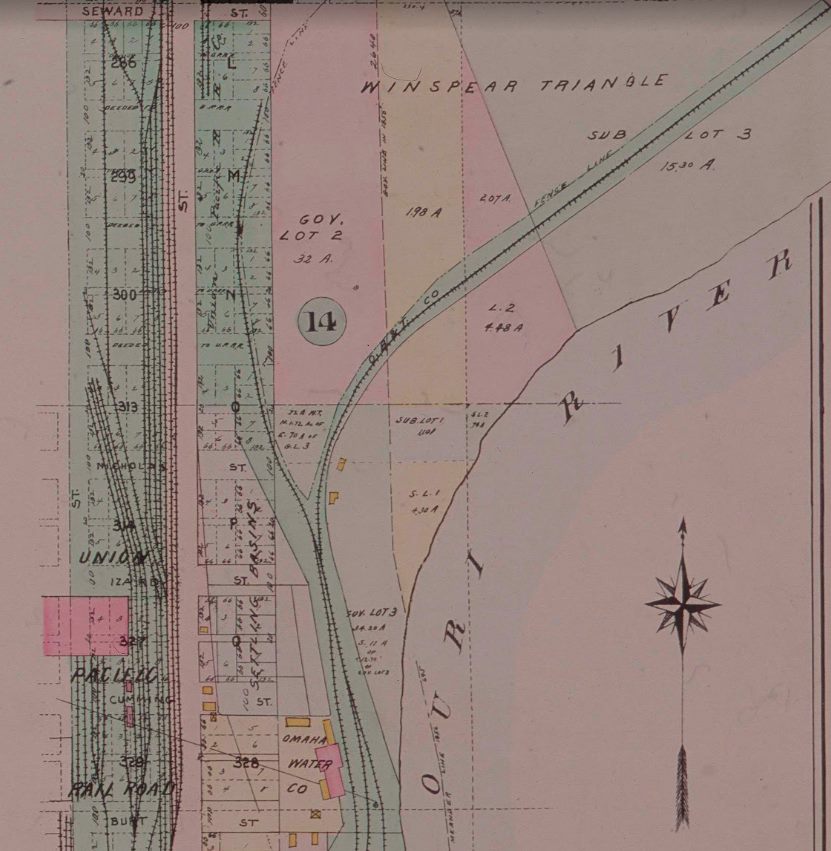
The Winspear Triangle bordered the North Downtown area. It was a city of Omaha investment scheme from before 1900 that was ill-fated, only amounting to substantive development after the 1990s. The Omaha Ford Motor Company Assembly Plant was later home to the Tip Top Products Company, which became the Tip Top Lofts in the early 2000s, are just north of North Downtown at 1514-24 Cuming Street and listed on the National Register of Historic Places. Similarly northwards, the Nicholas Street Historic District is bounded by North 11th Street, Izard Street, and North 14th Street and is listed on the National Register of Historic Places.

There was other culture in the North Downtown Omaha area, too. The neighborhood was home to a large Unity Church built in the late 1870s, located at North 17th and Cass Streets. In 1912, it was bought by the Omaha Musik Verein, a German music group that called the building the Omaha Musik Hall. Germans would come from all over Omaha and from German communities around Nebraska and Iowa to attend performances of Richard Wagner and Franz Schubert, among other German luminary musical artists. In 1922 the Eagles Aerie 38 bought the building and made plans to refurbish it to maintain the building as the club’s home. A fire there sent the Eagles out of the building in the late 1930s, but it kept standing into the early 1970s.
Brisk Business in North Downtown

There have been TONS of important businesses in North Downtown! Literally dozens of stores, then factories, then plants and warehouses, hotels, railroad places, and so much more. Originally, the North Downtown area was farmland on the edge of town. There were small settler’s homes built there between 1854 and 1864, with farmyards, barns, animals and fields planted.

One of the oldest service businesses in the area was the J. W. Cotton Livery and Sale Stables at 15th and Cass Streets, which opened in the late 1870s and stayed through the 1910s. The Little Gem Stable was at 1718 Cass Street, and after it was opened in 1890, it was managed by George and Lillian St. Julian starting in 1891. The Cass Street Carriage Works opened in the neighborhood in 1887, and the Badger Body and Truck Equipment opened at 1515 Cuming Street, staying there from 1919 to the 1960s. Its still open elsewhere. The same intersection was home to the Farm Tractor and Equipment Company. Other manufacturing happened at Rex Sales and Service from the 1910s through at least the 1930s, where they manufactured hardtops for open top cars and did other conversions.
The Bloom Millwork Company at 1502 California St. started in 1893 and didn’t close until the 1980s.

Canfield’s was a longtime iconic neighborhood institution. After being founded at 518 North 16th Street in 1948, it moved to North 24th and Cuming. Over the next half century it was popular, until it moved to west Omaha in the 1990s.
The Midway Tavern at 1608 Cass Street was an icon of its own, and served the area along with the Family Wine and Liquor House at 616 North 16th Street and the Meyer Klein Wholesale Liquor Dealer, which was at North 16th and California. Other businesses at that popular intersection were A. Holmes Hardware, Whitehouse’s Drug Store, the Denver Restaurant, and Omaha Mirror Manufacturing.


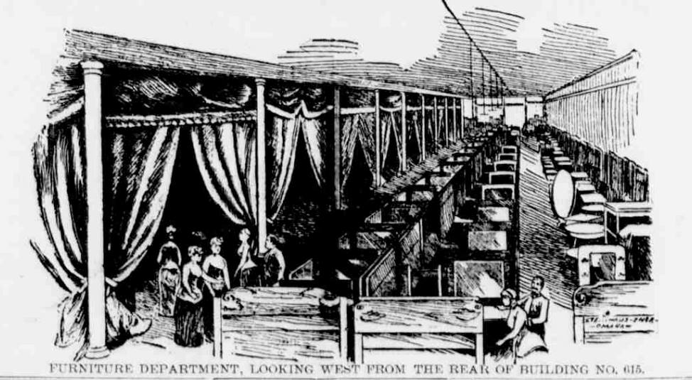


Learn about the People’s Mammoth Installment House at 613-621 North 16th Street in North Downtown Omaha from the images above.
The Gentlemen’s Grocery was at 501 North 16th Street, and the New England Furniture Company was at 710 North 16th Street. North Downtown Omaha was home to the People’s Mammoth Installment Company, later called People’s Furniture and Carpet Company, from 1889 to 1892. Originally advertising itself as a five-story furniture store that was the “Largest Credit House in the World, it was located at 613-21 North 16th Street. After a fire in 1892, it was relocated to 1315-1317 Farnam Street. Starting their advertising in the Omaha Bee in 1888, I can’t find another ad after 1894. In the meantime, there were fire sales, slaughter sales, $100,000 sales, $250,000 sales and A LOT more sales.
Since North Downtown was a central location for the whole city after the turn of the century, it only made sense that universal business services be located there. These businesses, including wholesale grocers, light manufacturers and construction supplies, also included funeral homes. In the first decade of the 20th century, Leslie & Leslie Funeral Home was at 519 North 16th Street; Hoffman & Gentleman Funeral Home was at 702 North 16th Street; Gentleman & Larkin Funeral Home was at 702 North 16th Street; and the J. A. Gentleman Mortuary was at 813 North 16th Street.

Tip Top Products Company was at two different locations in the neighborhood. Originally opened at 1508 Burt Street in the 1890s, they moved to 1515 Cuming in 1926 after the Ford truck factory moved out. They also had another building across the street at 1524 Cuming Street for their “Division Fabrege’,” which operated there until 1981.

Osthoff Sign Painting at 519 North 16th Street, Black’s Annex at 702 North 16th Street, P. H. Mahoney and Company at 813 North 16th Street, and a filling station at 1505 Cuming Street, which was there from 1921-1963. The George Bell Coal Company was at 1124 Cass Street for a few decades.

Alley Poyner Macchietto, which was located in the historic Tip Top Company Division Fabergè building at 1515 Cuming Street in the 2010s. An Art Moderne masterpiece, that building was demolished recently.
Hotels
The North Downtown area was packed with hotels! Given the number of visitors arriving at the Webster Street Station and the itinerant Union Pacific workers in the area, there was a bustling need for fast, easy, and affordable places to sleep. Some of the hotels there included the Warden Hotel at 817 North 16th Street, which was one of the few Black-owned hotels that existed at the height of Jim Crow in Omaha, along with the Booker T. Washington Hotel at 1719 Cuming Street.
Rex Hotel at 605 North 16th Street; Drexel Hotel at 618 North 16th Street; Northwestern Hotel at 619 North 16th Street; California Hotel at North 16th and California Street; Park Hotel at 1502 Cass Street, and; the Klondyke Hotel at 619 North 16th Street. The Chicago Hotel and the Midland Hotel were in the area, too. There were many others as well.
Railroads
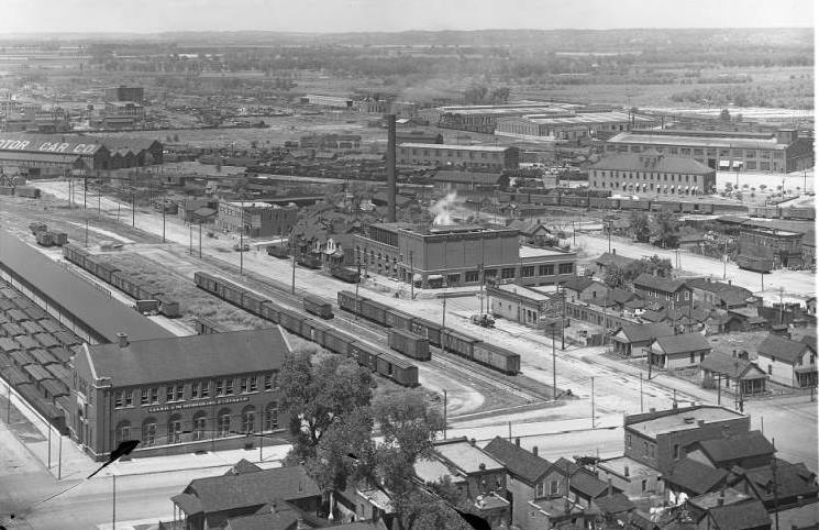
The railroad industry was easily the most influential force in this area of the city. Between the UPRR shops, the Webster Street Stations, and the beginning of the North Omaha Yards at the north end of the district, there were a lot of jobs and a lot of money, along with constant changes.
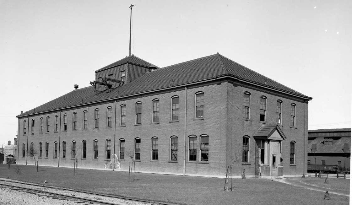
The Union Pacific Shops went from Cass to Cuming Streets, from North 13th Street east to 9th Street. The Union Pacific Railroad Shops grew from necessity. As the genesis for Cuming Street for more than a half-century, the UPRR Shops made everything from the bolts to the boxcars that made the Union Pacific great. In the 1950s the site was formally expanded to cover 100 acres of property. The shops’ importance in the company lasted until 1988, when the UP moved most of their maintenance operations out-of-state. In 2000, the Union Pacific voluntarily closed down the site forever. Today, standing about 50 yards south of Cuming on North 10th Street allows people to stand at the site of one of Omaha’s greatest industrial operations and contributions to the national economy.

Omaha’s Belt Line Railway started at North 15th and Webster Street, at the Webster Street Station. Although it wasn’t a business, per se, it launched dozens of North Omaha businesses and sent the real estate along its periphery into a whirlwind of development from the 1910s through the 1940s. The Webster Street Station was built in 1885, and was used by several railroads as a passenger depot at North 15th and Webster Streets. Some of the most popular included the Chicago, St. Paul, Minneapolis & Omaha (aka the Omaha Road); Fremont, Elkhorn & Missouri Valley; Missouri Pacific; and Sioux City and Pacific Railroads. In The Omaha Road was eventually acquired by the Chicago & North Western, and this station was used into the 1950s. The Missouri Pacific Freight Depot was at North 14th and Webster Street, and was different from the station.
Located in the UPRR Shops, the McKeen Motor Car Company was an innovative railroad car manufacturer that operated for 12 years between 1905 and 1917.
Toxic Work

The history of North Downtown Omaha includes tales of roaring entrepreneurs and simple businessmen, tycoons and accidental millionaires. In their ambition, many contributed to the toxification of Omaha by accident, while others did it on purpose. Longtime Omaha business leaders like Levi Carter of the Omaha and Grant Smelting Company and Jay Gould of the Union Pacific Railroad were key to these poisonous work. More than simply being next door neighbors in North Downtown, Gould aided the owners of the Omaha and Grant Smelting Company, and later Carter himself when he was the sole owner, by giving special rail use, cutting rates for shipping and ensuring the Union Pacific met all of the company’s needs. Similar deals were struck between and among a lot of toxic industries throughout Omaha, but especially among the ones that handled lead, and especially when they affected North Downtown Omaha.
However, it wasn’t just the titans of Omaha industry who were responsible. The EPA found more than 100 potential sources of the lead poisoning in Omaha, with dozens located in North Downtown. These companies poisoned Omaha in a lot of ways, including air emissions from lead refining operations, dumping contaminants in the Missouri River, the old North Omaha Creek, and probably other ways, too. They included companies located in North Downtown like Continental Can Company, Baton Metal Products Works, Gould National Batteries, Inc., Grant Battery Storage, and others.
Of course, Big Business did the worst damage. Asarco was responsible for $186.5 million in cleanup costs; the Union Pacific paid $25 million; Aaron Ferer and Sons cost $500,000; Gould, Inc cost = $1.4 million, and; NL Industries (Carter White Lead Company) got off scot-free. All of these businesses are gone from the North Downtown area now, replaced by the CenturyLink Arena, Hilton Omaha, and several new entertainment facilities and hotels.
Things Happened in North Downtown

Some of the significant events in North Downtown Omaha included launching the city’s first streetcar and its first park. In the 1860s, Omaha’s first-ever public transportation was routed up North 16th past Cuming Street to Izard Street. It was a horse-drawn streetcar, and ran until the 1880s. Omaha’s first Unitarian Universalist Church was at 17th and Cass. The first Church of the Holy Family was located at 17th and Cuming from 1868 to 1879. Its iconic building was constructed that year at 18th and Izard, and the old school was moved there. The first park in Omaha was called Jefferson Square, and it was location from North 16th and North 15th, from Cass to Chicago Streets. Omaha’s first public school was a two-room wooden structure opened in Jefferson Square in 1862.

With big business came significant events in North Downtown. In 1877 a railroad riot at the UPRR shops led to nearby military units being called out to stop the violence. The strikes were part of a nationwide series of strikes to protest the growing influence of railroad corporations in the U.S. These events led General Phillip Sheridan to recommend the permanent stationing of a U.S. Army regiment in Omaha.
On May 4, 1880, hundreds of workers at the Omaha Smelting Works surrounded the plant at North 9th and Cuming, and go on strike. When more than 100 African American men are brought in as strikebreakers, the strikers offered to pay their fares back to their homes. The black workers reportedly accepted, joining the white workers on the picket line until transportation arrived. The strike continued until at least May 21. That day at least 700 men paraded, as city leaders threatened to bring in the state militia. No word on how it ended.
There was a riot at the ASARCO plant on August 2, 1891. That day, a mob of 500 attacked the Omaha Granite and Smelting Works, later an ASARCO facility, damaging property and driving out workers. Police were reported powerless against the mob, and the mob was labeled drunk. No word on how it ended.
On June 28, 1902, protesters at the Union Pacific shops in Downtown Omaha go on strike with 1,800 workers affected across the Western United States. On September 14, 1902, a strikebreaker is killed by a group affiliated with the strikers. I can’t find any word on how it ended.
History Happening Today in North Downtown
Since 2000, there has been a lot of development and redevelopment in North Downtown. With the EPA designation as an environmental catastrophe, the toxic businesses that once easily polluted the area were swept out in the 1990s, and major investment dollars have been pumped into the area.
One of the first developments in the area was the CenturyLink Center and Hilton Hotel, which the City of Omaha built with tax dollars. “Creative investment” has allowed the rest of the area take off, with entertainment venues like The Slowdown, a music performance space; Film Streams at Ruth Sokolof Theater, an art film theater; and the Hot Shops Art Center, an innovative art space.
The local Blue Line Coffee shop is popular, while several new hotels have been built in North Downtown Omaha, including Fairfield Inn, Hampton Inn, Holiday Inn Downtown and Homewood Suites.
One of the newest and most important developments in the area is the home of the NCAA Men’s College World Series, the TD Ameritrade Park. Freshly moved from South Omaha’s former Rosenblatt Stadium, the College World Series is a boon to North Downtown every year.
However, in order for all this to be built a lot was destroyed. The demolition of more than a dozen buildings of varying importance has left a scar on the heart of the area, and it will be a long time before today’s developments have the meaning, history or stories of those old properties.
As Omaha’s relentless bulldozers keep plowing through North Downtown, the people who lived and worked in North Downtown are largely missing too. Gone are the stories of the pimps and hookers who once worked the many hotels; missing is the romantic notion of the immigrants who struggled to survive, or the hate-filled white supremacy that segregated African Americans from the city by hustling them into one section of the area.
After opening the Kiewit University in North Downtown Omaha in February 2017, the Kiewit Corporation announced they are moving their company headquarters to Burt Street in 2020. This easily makes Kiewit the largest modern employer in the area, and heralds the redevelopment of much of the area. Creighton University is credited for buying and demolishing buildings on much of the property in the area. Whether for their own predicted growth or to stem the blight once filling North Downtown is undetermined.
The future is ahead. Now that most of the historic architecture and people are gone, North Downtown Omaha is being promoted as a place for fun, entertainment and good times. We’ll see how that affects North Omaha, and whether there’s hope for everyone affected.
You Might Like…
- History of Cuming Street
- History of Italians in North Omaha
- History of Holy Family Catholic Church
- History of Tip Top Products Company
- History of the North Omaha Bottoms
- History of the Near North Side in Omaha
- History of the Winspear Triangle
MY ARTICLES ABOUT HISTORIC NEIGHBORHOODS IN NORTH OMAHA
National Register of Historic Places Historic Districts in North Omaha: 24th and Lake Historic District | Benson Downtown Historic District | Country Club Historic District | Dundee/Happy Hollow Historic District | Fairacres Historic District | Fort Omaha Historic District | Minne Lusa Historic District | Nicholas Street Historic District
Historic Neighborhoods in North Omaha: Bedford Place | Belvedere Point | Bemis Park | Benson | Briggs | Bungalow City | Carter Lake, Iowa | Central Park | Clifton Hill | Collier Place | Creighton University | Crown Point | DeBolt | Druid Hill | East Omaha | Fairfax | Florence | Florence Field | Fort Omaha | Fontenelle View | Gifford Park | Gold Coast (Cathedral) | High Point | Jefferson Square | Kellom Heights | Kountze Place | Lakewood Gardens | Little Russia | Long School | Malcolm X Memorial | Miller Park | Miller Park Duplex Historic District | Monmouth Park | Montclair | Near North Side | North Downtown Omaha | Omaha View | Orchard Hill | Plum Nelly | Prettiest Mile in Omaha | Prospect Place | Raven Oaks | Redman | Saratoga | Sherman | Squatter’s Row | Sulphur Springs | Ponca Hills | Wakonda | Walnut Hill | Winspear Triangle | Wyman Heights
Lost Towns in North Omaha: Benson | Briggs | DeBolt | East Omaha | Florence | Saratoga | Sulphur Springs
Elsewhere Online
- “North Downtown” webpage from Visit Omaha!
- North Downtown official website
- Kiewit University official webpage
- “Kiewit Corp. is moving its headquarters to north downtown Omaha” by Brad Davis for the Omaha World-Herald on December 18, 2017.
- “New workspace in north downtown Omaha aims to give a boost to young fashion designers,” by Chris Peters for the Omaha World-Herald on September 28, 2017.
BONUS PICS!


Leave a comment