Tracks, trestles, bridges, roundhouses, switching yards, maintenance shops and more left indelible marks throughout North Omaha. The Missouri Pacific, Omaha Road, Union Pacific and several other companies haunted the community. However, today, there’s nothing left aside from a few tracks, empty rail beds and a couple decaying bridges and trestles. Over the last 150 years there were five different railroad companies, a dozen depots, eleven bridges and trestles, two roundhouses and much, much more railroad infrastructure used to be scattered across North Omaha. This article is a lowdown of the history of railroads in North Omaha. Share your stories in the comments section that follows, please.


Missouri Pacific Railroad in North Omaha

Originally started by the Missouri Pacific, or MoPac, Railroad, the Belt Line railway was once a passenger service, then an industrial line for 75+ years. Today, there’s nothing left of it besides an empty rail bed.

Omaha Belt Line Railway
This NorthOmahaHistory.com graphic shows approximately where the Omaha Belt Line Railway ran through the community.

Of all the railroad-related history in Omaha, there are two things that excite me most. The first are the labor struggles in the industry, and the second is the Belt Line Railway owned by the Missouri Pacific Railroad. After starting at a station downtown at N. 15th and Webster, it went north along the bottom of the bluffs east of N. 14th to Locust Street, then crossing N. 16th on a trestle at Commercial Ave. Then it crossed Commercial before Ames Avenue, going between Taylor Ave and Ames (along a street called Boyd that doesn’t exist there anymore). There was originally a depot at 4351 N 22nd St along this section. Then, the Belt Line shot west and across 30th to a depot at 32nd and John Creighton Blvd, then to a depot at 40th and Lake, then a depot at 43rd and Nicholas, then a depot at Military and Hamilton, then south over Dodge and beyond.

Chicago and Northwestern Railroad in North Omaha

Debolt, North Omaha, Nebraska
A 1917 railroad map showing the Chicago and Northwestern Railroad through Debolt, as well as the northern connector to the Omaha Road through Briggs.

The railroad heading up the modern-day Sorensen Parkway was the Fremont, Elkhorn & Missouri Valley Railroad, which was bought by the Chicago and Northwestern Railroad. Starting downtown, the railroad travelled through the North Omaha Yards to Locust Street, eventually going west through the ravine now used by the Storz Expressway to North 30th, which it cross with a trestle. It then went to a station by Fort Omaha and onward to Debolt, Bennington, Irvington, Fremont and beyond.

The Omaha Road in North Omaha

Another railroad headed north from the Webster Street Station north to Florence and points beyond. It was the Chicago, St. Paul, Minneapolis and Omaha Railway, aka the Omaha Road.

Florence Depot Museum, North Omaha, Nebraska
This is the former Florence Depot, once located along the Omaha Road. Today, its a museum for Florence’s heritage.

After coming north along the bluffs, it went to a roundhouse north of Locust and west of Carter Lake Drive. It then went north to a trestle over Minne Lusa Boulevard and past the Minne Lusa Water Works, then to the Florence Depot at North 28th and Tucker. After that, it went to Briggs, Nashville, Blair and beyond.

Illinois Central Railroad in North Omaha

This is the old Illinois Central Railroad double-span swing bridge over the Missouri River in East Omaha. Locked open and poorly maintained today, it was once the widest double-span swing bridge in the world.

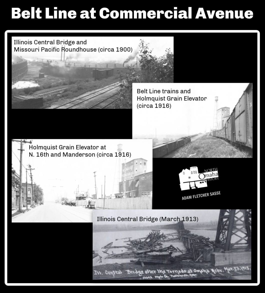
The Illinois Central Railroad crossed the Missouri River at East Omaha. Its more than 500 feet long, and was the longest swing bridge in the world from when it was completed in 1915. The IC then came east to a roundhouse at in old Sulphur Springs by North 13th and Wirt Streets. That roundhouse was demolished, and the railroad from East Omaha to North 13th was removed.

With the impact of the IC and other companies following its lead, by the 1920s, East Omaha was packed full of railroads. In addition to the bridge and the roundhouse, the IC had a terminus in East Omaha and maintenance yards at North 13th Street north of Locust.

Railroads in East Omaha, Nebraska circa 1900
This is a map of East Omaha in 1900 with the railroads highlighted. The UPRR, IC, CSPM&O, and the OBSTRR were all present at the same time! What isn’t show here are places like yards and roundhouses, of which there were several in the area.

The Omaha Road had a roundhouse and small railyards there, too, along with the UPRR line that ran to factories on the north side of Carter Lake. The IC spurs to the East Omaha Factory District was busy, and railcars constantly hauled ice from massive icehouses on the lake as late as the 1930s. While almost all of that infrastructure is gone today, its easy to imagine how busy the area was.

Today, the Canadian National Railway owns the East Omaha bridge, it is closed and locked open, and is poorly maintained.

Union Pacific Railroad in North Omaha

In this picture from the newspaper, Lee Wesley Gibson shakes hands with 66-year-old Willie James, a retired Union Pacific chef on Feb. 29, 2012. 101-yr.-old former Union Pacific porter, Lee Wesley Gibson, visits Union Pacific headquarters in downtown Omaha, Nebraska.

I’d be remiss to neglect the Union Pacific Railroad’s role in the history of North Omaha. They had no trunk line or bridge that spanned any part of North Omaha. They didn’t build a shiny station to benefit the community, or pour tons of money directly into the area.

Instead, north of Dodge Street they had a single line that wrapped around the north side of Carter Lake. And a massive rail yard north of Cuming Street beside North 11th Street, and their massive shops near at North 9th and Cuming Streets.

The Union Pacific Railroad also employed many North Omahans. From the early years of the railroad through the 1960s, African Americans were hired almost exclusively to work as cooks, waiters, and porters for the railroad. Other Blacks were hired by the Union Pacific as strikebreakers, and many migrated to Omaha from The South for these jobs in the late 1870s. Despite being paid menial wages and struggling to stay employed, by the 20th century a growing number of African American employees of the Union Pacific managed to maintain a middle class lifestyle in the Near North Side.

As the veil of white supremacy and workplace racism began lifting in the 1960s, African Americans achieved higher roles in the company. Eventually, some became stewards, inspectors and engineers for U.P. Today, there are Black managers throughout the company in Omaha and beyond.

However, when the working class Union Pacific jobs left Omaha en masse in the 1960s, North Omaha was adversely affected too. With remarkably fewer employment opportunities, youth found themselves without visions for the future and the immediate prospect of relieving tension and forcing attention to their situation led to rioting and protests in the community. Along with industries like the packinghouses and stockyards, and poor city leadership, the Union Pacific, along with the smaller rail lines in the city, was responsible for this.

Today, the heritage of African Americans working for the Union Pacific is celebrated at their museum in Council Bluffs, and by the Union Pacific Railroadโ€™s Black Employee Network, or BEN. BEN began in Omaha in 1979 with five employees, with more than 700 today. There are BEN chapters in St. Louis, North Little Rock, Kansas City, Memphis, Los Angeles, Fort Worth, Houston, Omaha, Chicago and Addis, Louisiana. The mission of BEN is to increase the recruitment, retention and advancement of African-American employees within Union Pacific, by promoting and facilitating personal and professional growth, and working with UP senior leadership on diversity issues. BEN also provides scholarships, encourages post-secondary education for high school graduates, and supports local African-American communities.

Depots and Stations in North Omaha

I’ve found at least nine stations in North O affiliated with various railroads. The Belt Line Railway began as a passenger transport, and required depots for pickup and drop off. They included the Webster Street station, the Oak Chatham depot, the Druid Hill depot, the Lake Street depot, the Nicholas Street depot and the Walnut Hill depot.

Missouri Pacific Lines Yard Office, North 15th and Grace Street, North Omaha, Nebraska
This is the Missouri Pacific Lines Yard Office at North 15th and Grace Streets.

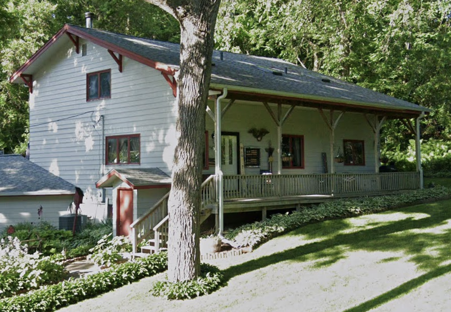
There were several other railroad depots in North Omaha, too. The Omaha Road had two stations in North Omaha, including the Florence Depot and theย Briggs Station.ย Located near McKinley Drive, Briggs Station was built around 1887 and abandoned by the early 1920s. The Briggs Station still exists and has been repurposed as a house on the old Washington Highway in the Ponca Hills.

The Omaha Heights Station was located near North 42nd and Hartman Avenue on the Fremont, Elkhorn and Missouri Valley Railroad between 1883 and at least 1917. Once the location of a large paint factory, this station was popular for several years.

After leaving north from downtown, the CNW used the Omaha View depot and the DeBolt station.

By 1876, there was also a separate stop for the Fremont, Elkhorn & Missouri Valley Railroad (later the Chicago and Northwestern Railroad) to serve Fort Omaha called the Briggs Depot. Located at 3190 Grand Avenue, it served the area for almost forty years until a grand crash demolished the building.  

Other Railroad Infrastructure in North Omaha

MoPac Roundhouse, North Omaha, Nebraska
In this 1926 pic, you can see the Holmquist Elevator on North 16th at Commercial Ave; the MoPac Roundhouse to the right; and the Ames Avenue bridge over Carter Lake. I’m not sure what that elevator is to the right; it would’ve been along the Omaha Road, maybe nearby the ice house?

Its challenging to account for all the railroad infrastructure in North Omaha, if only because there was so much of it. By far the largest place was called the North Yards. It was a massive area of rails, shops and other industry-related places that was located north of the Union Pacific shops, extending roughly from Cuming to Locust Street, from North 9th to North 14th Street.

There were trestles over Cuming around North 40th; over North 30th at Hartman; over Minne Lusa Boulevard near JJ Pershing Drive; and over North 16th Street at Commercial Avenue. There was also a large a viaduct on Locust from North 11th to North 16th, and another over Nicholas from North 13th to North 16th Street.

There were two roundhouses north of Locust Street and east of North 14th.ย One was operated by the Missouri Pacific, and the other was for the Omaha Road. There wereย also at two train bridges across the west arm of Carter Lake operated by the Illinois Central Railroad.

Railroads in North Omaha
This is a map of railroad routes, roundhouses, bridges, depots and stations in North Omaha.

North Omaha Railroad Tour

Much the same as railroad infrastructure across the United States, North Omaha’s depots, stations, trestles, bridges, roundhouses and rails themselves have largely faded from the community’s landscape. However, their places don’t have to be lost! Here’s a list of railroad places in North Omaha.

Omaha Missouri Pacific Railroad Passenger and Freight Depots
This Sanborn Insurance map shows the Chicago, St. Paul, Minneapolis & Omaha Railroad Passenger Depot and Freight Depot at
  • North Yard, N. 11th and Nicholas St (demolished)
  • Missouri Pacific Freight Depot, N. 14th and Webster St (demolished)
  • Webster Street Station, 1490 Mike Fahey St (demolished)
  • Oak Chatham Depot, 4351 N. 22nd St (demolished)
  • Druid Hill Depot, 4230 N. 30th St (demolished)
  • Lake Street Depot, 2480 N. 40th St (demolished)
  • Nicholas Street Depot, 4360 Nicholas St (demolished)
  • Walnut Hill Depot, 4242 Hamilton St (demolished)
  • Florence Depot, 2800 Tucker St (standing)
  • Briggs Depot, 3190 Grand Ave (demolished)
  • Briggs Station, 5300 Sargent St (demolished)
  • Omaha View Depot, 3200 Grand Ave (demolished)
  • DeBolt Station, 7000 N. 60th St (demolished)
  • Omaha Road Roundhouse, 35 Carter Lake Shore Dr (demolished)
  • Missouri Pacific Roundhouse, 35 Carter Lake Shore Dr (demolished)
  • Illinois Central Bridge, 41ยฐ16’44.4″N 95ยฐ53’31.8″W (standing)
  • Missouri Pacific Trestle, 4448 Cuming St (demolished)
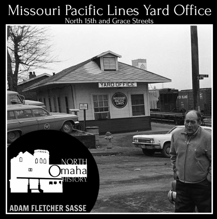
  • Missouri Pacific Railroad Yard Office, N. 15th and Grace Street (demolished)
  • Chicago and Northwestern Trestle, 4900 N. 30th (demolished)
  • OPPD Trestle, 41ยฐ19’39.1″N 95ยฐ56’25.6″W Minne Lusa
  • Omaha Road Trestle, 41ยฐ19’37.2″N 95ยฐ56’58.4″W Minne Lusa (standing)
  • Missouri Pacific Trestle, 4140 N. 16th (demolished)
  • Union Pacific Bridge, 4405 Carter Lake Shore Dr. W (demolished)
  • Locust Street Bridge, 1415 Locust St (demolished)
  • Locust Street Viaduct, 1415 Locust St (demolished)
  • Nicholas Street Viaduct, 1450 Nicholas St (demolished)
  • Missouri Pacific Carter Lake Bridge,ย 35 Carter Lake Shore Dr (demolished)
  • Omaha Heights Station, 3701 North 42nd St (demolished)

Other railroad-related places included the Railroad Menโ€™s Benevolent and Social Club at North 24th and Miami Streets in the 1950s; and the Waiters and Porters Headquarters was located in today’s Blue Lion Center at 2421 North 24th Street from the 1930s into the 1950s. The Sleeping Car Porters Headquarters was located at North 27th and Lake in the 1920s and 1930s, but I haven’t figured out where at that intersection yet.


You Might Like…

Elsewhere Online


BONUS PICS!

Omaha Road Roundhouse, North Omaha, Nebraska
The Omaha Road roundhouse was located in the former Sulpher Springs, north of Locust Street and west of Carter Lake Drive West. It lasted from approximately 1890 through the 1950s. In 1913 it was demolished by the Easter Sunday tornado, and rebuilt later.
Nicholas Street Viaduct, North Omaha, Nebraska
Looking south towards downtown from the top of the Nebraska Consolidated Mills on North 16th, you can see the Nicholas Street Viaduct in the center of the pic. The Missouri Pacific Railroad freight house is on right (west) and the CMO ice house is to the left left (east).
Omaha Road Roundhouse, N. 13th and Locust Streets, North Omaha, Nebraska
This is a 1901 diagram of the Omaha Road Roundhouse at N. 13th and Locust Streets.
North Railroad Yards, N. 13th and Yates Streets, Omaha, Nebraska
This is Omaha’s North Yard in 1951. Located between Cuming and Locust between North 8th and North 14th, it was packed with railroad-related shops, spots and more.
Missouri Pacific Freight Depot, Omaha, Nebraska
This is Omaha’s Missouri Pacific Freight Depot, located at N. 14th and Webster Streets.
This is a 2007 map of active railroads in Douglas County from the Nebraska Department of Transportation.
Railroads in North Omaha, Episode 47 of North Omaha History Podcast by Adam Fletcher Sasse with Steve Sleeper
Omaha Road Roundhouse, North Omaha, Nebraska
To the south of the Ames Avenue Bridge was Omaha Road roundhouse, built c. 1890 and demolished c. 1960. Located north of Locust Street and east of Carter Lake Drive, it was demolished by the 1913 Easter Sunday tornado and rebuilt afterwards.
Historical surveyors with the State of Nebraska believe this structure was built in 1856 as a roadhouse, then became the Briggs Station. It is located at 9618 Calhoun Rd.
Missouri Pacific Roundhouse, North Omaha, Nebraska
This was the Missouri Pacific Roundhouse in North Omaha. Located south of Cornish Boulevard and east of Carter Lake Drive, it was built around 1890 and demolished around 1965.
1908 Illinois Central bridge over Carter Lake
This is a 1908 pic of the Illinois Central bridge over Carter Lake, located north of Locust Street and south of Cornish Boulevard.
This is a history of the Webster Street Station in Omaha, Nebraska.

Comments

67 responses to “A History of Railroads in North Omaha”

  1. Thank you for your fabulous articles on the history of North Omaha. I write a family history blog and many of my ancestors settled in Omaha, including North Omaha. My North Omaha family were Swedes and railway people. I have learned a great deal from your blogs and will include links to them in my future posts about the Nichols family.

    1. Thanks – that’s awesome to hear! I hope you’ve seen my articles about the Scandinavians in North Omaha, Vennelyst Park and the other Swedish-ish things I’ve written about. Thanks again for your note!

      1. Adam,
        I live next to the Omaha Country Club and write occasional articles for the club newsletter. I am interesting in finding out about the line that ran through the club property north from the Debolt station. There is evidence of the line going north through the club with a date of 1919 on a former trestle support, so I know where that line route was located. What is puzzling is there is evidence for another line that branches off in the middle of the golf course and runs northwest towards I680 and 72nd St. Are there any maps that might show these lines running north from Debolt?

    2. John Roberts Avatar
      John Roberts

      I agree, this is a wonderful article. My grandfather was yard master for the Chicago, St. Paul, Minn and Omaha in Omaha. I have very distant memories of him working in the Yards. I wish I could get more information about him and be able to identify the location of a picture I have of him at the Yards. Like treeklimber, my grandfather was Swedish. I will try to find your other articles. By the way our you familiar with the Golden Rail Bar?

      Thanks

      1. alicefromdallas@me.com Avatar
        alicefromdallas@me.com

        John, my Irish grandfather was a conductor on the C, St.P, M & O, as my parents referred to the line when I was a child. I was much older when I figured out those initials stood for. I have a picture of my grandfather and 3 other gentlemen standing by a train. I would be glad to send you a copy if youโ€™re interested. I also have a number of pencils stamped with the above initials. I would send you one if you are interested. The picture was taken sometime before 1948.

    3. John Roberts Avatar
      John Roberts

      I am trying to learn more about my grandfather who lived and worked in Omaha. I have a picture of him and his friend at the rail yards. He was Swedish as well. Can you tell me how to find your blog?

  2. Mike Avatar
    Mike

    Good information regarding Omaha’s RR history…… It gort me thinking…..

    I lived at 1709 84th st in the early 1060s. I was just a toddler at the time. I recall seeing a train pass by one night behind the house across the street. Further research shows RR right of way for the CNW RR behind the house across the street (see 1960 arial photo at:http://memories.nebraska.gov/cdm/compoundobject/collection/opl/id/2005/rec/21 page 210 ) . This rail bed looks to be abandoned and is now part of the Keystone Trial.

    My question is, was there ever a RR behind the house across the street from 1709 84th . If so, what is the history around this abandoned stretch of track ?

    Thanks

  3. Kathy Ryan Avatar
    Kathy Ryan

    I was hoping someone could give me some information about the Nicholas street viaduct. Can anyone tell me when the bridge was demolished? Thank you for your time.

  4. Hi mr. Roberts. My name is Ray and I worked for mop from 1971 until (after) they merged with the u.p.r.r. ,(figure in a 3 year hiatus for the army). I really enjoyed my time working there. Well.except for the winter storms, 100 plus days & all of the crummy hours. Really though, it was with a great bunch of guys! A reunion would be great, but most of the characters have passed away and it seems like for one reason or another no one ever keeps on touch for long.
    During my career with mopac, I was a switchman brakeman, & a yardmaster.. (or lovingly ? referred to as a yardmonster). So hopefully I can answer a few questions.
    I don’t remember a “golden rail bar” but after work sometimes we’d go to the Broken wheel bar. Might have been the same place. It was just north of the nighthawk cafe and just south of Carter lake drive. Nothing like a shot % a beer at 7 a.m. That was our 5 p.m. Get off work drink, but in those days it sure brought on more than few funny lips at other bars.
    Feel free to ask any other questions. I love the memories!
    P. S. I didn’t do it on purpose but we built our last house right on top of where there used to be mops tracks leading to louisville. The b.n. tracks that ran parallel to mopac’s is literally a stone’s throw away.

    N

    N

    1. DENNIS KETTLER Avatar
      DENNIS KETTLER

      Hey Ray:
      Which rail yard in Omaha (name & location please ) did MoPac use for classification and switching?

      thanks
      Dennis Kettler
      St Louis MO

    2. John Roberts Avatar
      John Roberts

      I am sorry it took me so long to reply. Thank you for your memories of the railroad. I am guessing you did not know a Joe Roberts while working at the yards. I have memories and have heard stories of the guys getting a drink after work.

      1. John Roberts Avatar
        John Roberts

        I would like to post the picture but can not figure out how to do it.

  5. You mentioned that Briggs was near Fort Omaha, but from what I’ve seen , it was near 60th and McKinley. Where the line split with one going north to Blair and the other going south towards Debolt. Using Google maps you can still track the roadbed from Briggs to Debolt. It went through Omaha Country Club and is parallel to one of the fairways.

    1. Thanks for catching that Carl. Briggs was at 60th and Rainwood,

      1. Do you have any idea when the track from Briggs to Debolt was abandoned? On the USGS quadrangle map of 1956 it is gone.

      2. No idea Carl–if I was writing about it, I would say that it was closed by 1956.

      3. Jim Rogers Avatar
        Jim Rogers

        I have some questions about the location of Briggs, but I will ask them on the “A history of lost towns in North Omaha” page.

  6. Joe Sobota Avatar
    Joe Sobota

    I just recently discovered your great work on North Omaha history and am reading your three volume history now, Concerning Carl’s question on when the DeBolt-Briggs connector was abandoned, your section above on the Chicago Northwestern has a map dated 1917 with the connection clearly marked. As Carl mentioned, you can see on Google Earth that the line went through what is now the Omaha Country Club. Also, having lived nearby and being familiar with the local topography, I can tell you that that would have been the only logical route to minimize the grade to about a 150 foot increase from Briggs to DeSoto over a bit more than 2 miles. The OCC bought their current property in 1925, with the golf course opening in 1927. So I guess we can narrow the year of the abandonment to sometime between 1917 and 1925.

    I grew up in Minne Lisa near 25th and Ida. Went to Blessed Sacrament grades 1 through 8 during the 1950s (Minne Lusa School for K). I remember so much from those years, including lots of trains on the “Omaha Road” (wholly owned by the CNW, but legally separate until 1982) from downtown through Florence and beyond. When I heard a train whistle at a grade crossing, I usually had enough time to hop on my bike and get over to the crossing at Reed Street near Florence Blvd to watch it pass. There was also traffic on the CNW line from downtown to Irvington, Bennington, Arlington and beyond. And the Omaha Beltway was active too.

    Later, in 1966, my parents built a house north of McKinley on 62nd Street.. Our lot, like all those on this street, bordered the CNW right of way which was in a deep cut through the high ground between the Mill Creek and Ponca Creek watersheds. This was a steep grade from about 60th St, through the first cut behind our house, and finally up to an even deeper cut north of us where the grade finally leveled out. I remember that from time to time crews would split their train if it was too heavy to make the grade – there was a siding along part of this grade that was used for this purpose.

    Again, I really enjoy your research!

    1. Hey Joe, thanks for the note–I appreciate your interest! I would love to walk that old route from where the roundhouse was up to the Florence Depot, out to the Briggs Depot and northward… then double back and walk down to where the DeBolt Depot was… I can only imagine what it would have been like!

      I think that cut you mention had a specific name, but I don’t remember it. There is so much more detail than what I’ve documented so far, and there are several other people who know more than me about the railroads in North O. If only they’d write free content, I would love to share it and promote it!

      Alas, I’ll keep piecing together what I can. Let me know if there’s anything specific you want to see more about, and I’ll see if I can go digging! Thanks again for your note.

      1. Joe Sobota Avatar
        Joe Sobota

        Hi again, Adam. I think I saw a reference to โ€œsouth cutโ€ somewhere. That would make sense because there was an even deeper cut on the north side of the Ponca Creek watershed which at the top of the grade was bridged by Northern Hills Drive. Sometime in the early 1970s I did walk the 0maha Road line from behind our house and the โ€œsouth cutโ€ northward up the grade through the โ€œnorth cutโ€ and on to Nashville. There was a lot of wildlife in that corridor and my dog Fox scared up a real fox on our hike. After a merry chase my Fox rejoined me on the track full of burrs I had to get out of his coat.

        One more observation. When I lived in Minne Lisa, coal trains to supply the OPPD power plant were switched off the CNW/Omaha Road near the Pershing Drive bridge, not the current UP line which is used now and was extended from East Omaha. Not sure when that happened.

    2. Frank Dowd Avatar
      Frank Dowd

      Hi Joe, Frank Dowd here. I found you comments when searching Omaha railroads, especially maps of the railroads.
      Your comments were very helpful.
      Hope all is well.
      My email is below,

      1. What a great surprise if you are Frank Dowd, son of my godfather, Dr. Frank Dowd, my father’s lifetime friend. I apologize for he delay in responding – I was distracted while going through a pile of email. And never got back to the rail blog.. Send me your email so we can take this off the blog.

  7. Joe Sobota Avatar
    Joe Sobota

    Adam – I remember now where I saw a reference to “South Cut” on the Omaha Road. It appears on a 1940 timetable between Florence and Nashville stations. There is a poster sized version of this timetable displayed in the Florence Station Museum and a great photo on its website. Note that there were two trains a day each way between Omaha and Minneapolis in 1940. Do we know when regular passenger service ended?

    1. Hi Adam and Joe, I found a 1938 map of the Union township and it showed the Briggs to Debolt connector was the east border of Omaha Country Club .It showed another person owed the remainder going towards 60th st. The country club must have bought the rest of the property after 1938 if the map is correct. It looks like the 8th and 10th fairways were located so the roadbed and associated ballast would not have to be completely removed. This is only speculation. I’m going to try contacting the country club to see if anyone there can fill in some of the blanks. Thanks

      1. Joe Sobota Avatar
        Joe Sobota

        Great info, Carl! Look forward to any updates you find on this.

  8. Jim Rogers Avatar
    Jim Rogers

    Joe and Carl–

    The abandoned rail bed between DeBolt and Briggs is clearly visible just a few feet east of the intersection of N. 66th St and State St. Looking to the south, you can see it going into the golf course and to the north you can see it heading toward DeBolt. It’s particularly visible in the winter when the leaves are gone.

    I live in the area and have regularly driven around looking for remnants of the connector and the two lines it connected. Still plenty of small remnants visible, and it’s really interesting to pick them out!

    1. Joe Sobota Avatar
      Joe Sobota

      Thatโ€™s great, Jim! I know right where you talking about. Next time iโ€™m back in the area to visit family, Iโ€™ll check those places out.

      1. Hi Jim and Joe, I was back in Omaha last week but had other things going on. I called Jordan Selbec at Omaha Country Club today to see if there is anyone still alive that knows if the connector through the golf course was still used in the early days of the golf course . She had no idea what I was talking about, but she said that there were some older people she could talk to. I’m doing this research kind of long distance since I live near Durango Colorado these days, but I will be back in late August to look around the course as Jim was saying. It’s funny that both Field Club and Omaha Country Club were both designed by the same person and both had a train line going through the property. I wish I had known more of this in the 1960’s, but you know, teenagers!!!! I’ll will let you know what I find out. Carl

      2. Joe Sobota Avatar
        Joe Sobota

        Good to hear you’re on the case, Carl! You have some great trains and railroad history in Durango too. I’ve ridden the steam train to Silverton and explored the old narrow gauge Rio Grande routes in Colorado and New Mexico. Thanks for keeping us in the loop on whatever you learn about the Briggs-DeBolt connector. – Joe

  9. Dave Mills Avatar
    Dave Mills

    We enjoyed reading the article and the comments. We live at 60th & McKinley and have been told that the Briggs station was on our property. We have the split where the Omaha Road ran towards Florence and the (I think Debolt connector from what I’ve been reading) line split south towards the OCC. Does anyone know of any photos that are available of Briggs Station? We have been trying to research the station and this is the best information we have found so far. Thank you!

    1. Jim Rogers Avatar
      Jim Rogers

      Dave– if you have the split, that means you’re on the SE corner of 60th and McKinley, correct?

      1. Dave Mills Avatar
        Dave Mills

        Yes, that is correct.

    2. Jim Rogers Avatar
      Jim Rogers

      (Replying here as the website won’t let me reply directly your answer to my question.)

      The maps I’m looking at (from 1909, 1920, 1925) show the split happening pretty close to 60th street (the maps make it look like the split occurred just a few feet east of 60th).

      For the station to have been on your property, it seems like it would have had to have been very small to have fit between 60th St on the west and the split line that headed to DeBolt (or the OCC, as you say) on the east.

      Not saying it wasn’t there, as it is entirely possible that it was a very small building that may have been right up against 60th, especially since that might have been a much narrower street/road back in the Briggs Station days.

      1. Joe Sobota Avatar
        Joe Sobota

        Hi Jim and Dave. If you check out the area on Google Earth, you can still see the “wye” at Briggs, now identifiable by tree lines. There appears to be plenty of room for a small structure between the west leg of the wye and 60th. I’ve been looking for a picture without any luck.You might visit the Florence Station museum – if you’re lucky maybe a volunteer railfan may have some ideas if they don’t have one on site. An inquiry to the Nebraska State Historical Society might be useful too – they do have photographic collections.

        I’m still curious about when the connector was abandoned.

  10. Dave Mills Avatar
    Dave Mills

    Thank you for the replies! The split is about 600 feet SE of N 60th St., and we have been told the building was small and just before the split. I will check with the Florence Museum and the historical society. Thatโ€™s a great suggestion!

    We had a gentleman here at our house about four years ago that was old enough to remember the station and the rail cars full of grain going to the mill. I wish we had gotten his contact info and some more stories from him!

    1. Joe Sobota Avatar
      Joe Sobota

      Dave – When you visit the Florence Station Museum youโ€™ll see a great 1940 timetable for the passenger service from Omahaโ€™s old Webster Street Station to Minneapolis using the Omaha Road right through your property. Let us know if you find something interesting!

      1. I received some info this morning from the Chicago & Northwestern Historical Society in Illinois. They said the DeBolt connector was built in 1905 and abandoned in 1930. They also said they did not have a photo of the Briggs station but would continue to look.
        I see there is a book about the Omaha Road written by Stan Mail and the Nebraska Historical has a copy. It might be worth a look. Thanks , Carl Pigaga

      2. Joe Sobota Avatar
        Joe Sobota

        Thank you, Carl! Iโ€™ve been wondering about those connector years since I learned there had been one! I have the Omaha Road history by Stan Mailer (2004). Itโ€™s a great resource, loaded with photos, but nothing about the Briggs-DeBolt connector. I also have a book from the Photo Archive series on the Omaha Road 1880 – 1940, edited by P.A. Letourneau (1997). This book relies heavily on photos from the State Historical Society of Wisconsin, but has lots of interesting stuff. Great pictures of equipment, but nothing on the Omaha area. Thanks again for your research!

  11. Jim Rogers Avatar
    Jim Rogers

    Dave: You’re right. Instead of looking at the hand-drawn plat I was referring to yesterday, I instead just went to a historical aerial from 1952 where the tree lines still show remnants of the old split. Using the measuring tool on that site, it shows the split starting at about 600′ from 60th street, just as you said. So there is plenty of space for a station– even a large one.

    On a related topic: Did the person you talked to (or do you yourself) know anything about the location of the *town* of Briggs? On the North Omaha History post on “Lost Towns of North Omaha,” I made some comment posts trying to pin down exactly where the town was, and if it even existed (maybe there was just a station?). Would be interested if you had any info on that.

    Carl: Interesting information from the historical society, but it seems to conflict with four different maps from 1889 that clearly show the DeBolt connector in place:

    http://www.historicmapworks.com/Map/US/224452/Page+063+++Township+16+North++Range+13+East++Florence++Missouri+River++Omaha++Hyde+Park++Kensington++Edgewood+Park/Douglas+and+Sarpy+County+1889/Nebraska/

    http://www.historicmapworks.com/Map/US/224408/Douglas+++Sarpy+Counties+Outline+Map/Douglas+and+Sarpy+County+1889/Nebraska/

    http://www.historicmapworks.com/Map/US/224409/Nebraska+State+Railroad+and+County+Map/Douglas+and+Sarpy+County+1889/Nebraska/

    http://www.historicmapworks.com/Map/US/224409/Nebraska+State+Railroad+and+County+Map/Douglas+and+Sarpy+County+1889/Nebraska/

    I wonder if the historical society would have an explanation for that.

    1. Jim Rogers Avatar
      Jim Rogers

      Sorry, looks like one of my links was a duplicate. Here is the correct one:

      1. Hi Jim, Did you get that last map from the Library of Congress website? If so, you can really enlarge the map and it shows a forth line coming out of the Briggs area. In one other map I saw it kind of looked like it might have led to Fort Omaha from the northwest. If it did, it would have probably gone up the valley between Cooper farm and Forest Lawn. This is pure speculation right now, but I’m trying to rationalize that 4th rail line in the 1889 map. does anyone have a map of Fort Omaha in this time period? Carl
        PS I wonder if the Chicago & Northwestern acquired the DeBolt- Briggs connector in 1905. I see the Fremont, Elkhorn & Mo. Valley owned it before. That might explain the 1905 date they gave me.

      2. Joe Sobota Avatar
        Joe Sobota

        Hi, Jim and Carl. My history of the CNW (by H. Roger Grant, 1996) has a lot of information on its predecessor companies, including the Omaha Road and the Fremont and Elkhorn Valley. The latter’s line from Arlington to Irvington to Omaha’s North Yards dates from 1887, including the important 10-mile connection to the South Omaha stockyards from Irvington. The Omaha Road’s line through Florence to Blair dates from 1881 (replacing an earlier alignment along the Missouri River bottom prone to flooding which was constructed by a bankrupt predecessor, the Omaha & Northwestern, in 1870 and seriously damaged in the flooding of 1881).

        The CNW acquired majority control of the Omaha Road in 1882, but the latter remained legally separate and even had its own headquarters in St, Paul. The Fremont and Elkhorn Valley was absorbed into the CNW in February, 1903.

        Thanks so much, Carl, for those great map links!

  12. Hi Joe, This is an update to what I wrote this morning. I just found a railway map of Nebraska dated 1889 in the Library of Congress website. If you look at it closely you will see the Briggs-DeBolt connector as of 1889. What is more interesting, you can see another line just to the east that is also heading into Omaha. So according to that map, tracks went out in 4 directions from Briggs depot. That puts into question the build date of the connector and adds a little mystery about the previously unknown set of tracks. I need to find more old maps.
    Carl

  13. Joe Sobota Avatar
    Joe Sobota

    Sorry, Jim! I meant to thank you for those great map links. You, Carl, and Dave have all added a lot to this enlightening discussion. Thanks too to Adam for providing this forum to add to our knowledge of North Omaha railroad history!

    1. Jim Rogers Avatar
      Jim Rogers

      No problem– I knew what you meant. ๐Ÿ™‚

      I agree that this has been a fun discussion and thank AFS for this site and all the discussion/research it has spawned.

  14. Jim Rogers Avatar
    Jim Rogers

    Carl: (1) I don’t remember where I got that last map as it was a while ago that I found it, but if you hover over the image you can see the link. It’s a “tile.loc.gov” site, but I can’t get anything to come up when I shorten it so I’m not sure what the source is.

    (2) I hadn’t noticed it until you mentioned it, but that map does appear to show a fourth line coming out of Briggs. Good eye! I agree that if there was a line in that area, it would have likely split off and followed Mormon Bridge Road (at least for a ways).

    (3) Your theory on the 1905 date for the DeBolt connector is very reasonable.

    Joe: Thanks for that history! As a side note, I grew up right near 90th and Boyd, and remember when that stretch from Irvington going south was still active.

    1. Joe Sobota Avatar
      Joe Sobota

      Hi again, Jim. In one of the sources I have read – and I canโ€™t remember which right now – one reason for the Briggs – DeBolt connector was to provide Omaha Road traffic an easier direct access to the South Omaha stockyards – via Briggs-DeBolt-Irvington – without having to navigate through congested downtown Omaha over other carriersโ€™ lines. In 1880 when the Omaha Road was organized (just two years before CNW acquired a controlling interest) and for decades afterwords live cattle were a major commodity for western railroads, and the Omaha stockyards were a prime market.

      1. Jim Rogers Avatar
        Jim Rogers

        Joe: I had speculated on my own what you just laid out as to the purpose of the connector. In addition, I wondered if maybe it was created so that traffic could easily “turn the corner” to go west from Briggs. E.g., if goods needed to go from Blair to Fremont, it would be tough to do on CNW lines if your had to go to Florence/Omaha. With the connector, you go pretty much straight south from Blair to Briggs, turn to corner from Briggs to DeBolt and you’re on your way west.

        One problem with both western travel and stockyards access theories is the question as to why it would have been abandoned in the 1930’s. This was a time at which the south Omaha stockyards were booming, on the way to its peak in the 1950’s. Why would they suddenly decide they didn’t need the connector in 1930?

  15. Dave Mills Avatar
    Dave Mills

    Jim, the only info I have on the town of Briggs is the rail station and the post office which was located a little east of our property. I am amazed at how easily it is for history to be lost with no records being saved. Iโ€™m sure there are photos out there somewhere, but finding the right person will be the challenge!

    1. Jim Rogers Avatar
      Jim Rogers

      Thanks for that, Dave. You are certainly right about lost history.

      As I said in a comment on the “Lost towns of North Omaha” page, I wonder if there really was a town of Briggs. I’m starting to think that the town didn’t really consist of any residents, just a station and a post office. I suppose someone who knows how to do it would need to see if there was ever a village or town by that name registered, incorporated, or whatever it would take to become an official population center of some sort.

      On the other hand, it seems that every old map shows a town called Briggs, and it’s so funny that all the google maps to this day call the area “Briggs” based on those old plats and such. So, maybe there was a town with residents.

      But on that “Lost Towns” comment that I posted, I lay out all the info I could find, and if there was a town there the plats don’t show it any evidence of it.

    2. Joe Sobota Avatar
      Joe Sobota

      Hi again, Jim. There’s a problem with your “turn the corner” theory. Long before the Omaha Road relocated the old Omaha-Blair line away from the Missouri River bottom, and through Briggs, in 1881, there was already a direct line from Blair to Fremont. The Sioux City & Pacific constructed that line in 1871 to connect its traffic from Iowa to the UP’s just-finished transcontinental line in Fremont. (a bridge across the Missouri between Blair and Missouri Valley was constructed in 1883).

      The SC&P joined the CNW system in August 1901, and that line was part of CNW’s mainline from Chicago west to the transcontinental UP connection in Fremont and remains so today after UP absorbed CNW.

      Concerning the 1930 abandonment, my guess – and it is just speculation – is that the anticipated traffic declined during the depression. Also, most of the area served by the Omaha Road in Nebraska was actually closer to Sioux City than to Omaha, and they had large stockyards there too.

      Of course, it might be something completely different – maybe the Omaha Country Club made them an offer they couldn’t refuse.

      1. Jim Rogers Avatar
        Jim Rogers

        I, see. I wasn’t aware that there was already a line that allowed a westward turn from the Omaha Road line.

        I was aware of Sioux City having stockyards, but didn’t know how big or competitive they were. I’ve always been under the assumption that there was no real regional competition to the Omaha yards, explaining its growth. However, I know almost nothing about the history of livestock trade, so I don’t put much stock (so to speak!) in that idea.

        If it was the case that northern competition for the cattle trade was significant, maybe the connector was abandoned simply because it wasn’t needed. They could already turn west via the line you just told me about and if not that many cattle were coming to Omaha from up north, maybe they just didn’t need that connector anymore. Combine that with the OCC, and maybe that’s why they gave it up– there was no real rationale for it.

        But then it raises the opposite question– why, then, did they build it in the fist place?

      2. Joe Sobota Avatar
        Joe Sobota

        The 1880’s were a golden age for rail expansion, especially in the newly settled agricultural lands in the Midwest. There were plenty of investors, at least until a break during the more troubled times after the Panic of 1893. The Omaha Road line from Omaha to Blair through Briggs was relocated in 1881 and the Fremont and Elkhorn Valley line from Irvington through DeBolt to downtown was built in 1887. All of Nebraska’s major railroads were buiding branch line networks and spurs. It was a time of optimism – and risk taking. Not every investment worked out,. Gradually at first, unprofitable lines were discarded. The Briggs-DeBolt connector may just be an early example of a process which accelerated with the expansion of road and air traffic, regulatory problems, and the rationalization of duplicitous service as railroads merged to remain economically viable.

  16. Joe, Carl, Jim, et al:

    I keep a private Omaha history mystery group on Facebook, and posed a problem related to the Briggs Depot to them. However, in trying to explain the situation, as you all know, these railroad things get so tangled so quickly. Here is how I tried to elaborate the situation:

    The Chicago, St. Paul, Minneapolis and Omaha Railroad was also called the Omaha Road. The Omaha Road went from the Webster Street Station at 15th and Webster Street to the Florence Station, to the Briggs Station and then northwards.

    The officially-named Northwestern Depot was located in Council Bluffs on the Chicago and North Western Railroad, aka the Northwestern. It traveled to downtown Omaha over the UP bridge, then went north through the North Omaha Yard to present-day Storz Expy/Sorenson Pkwy, then west to the DeBolt Station, then to Irvington and points beyond.

    However, the Northwestern owned a controlling stake in the Northwestern. They built a connector from Briggs to DeBolt in 1905.

    So, the Northwestern owned the Northwestern Depot in CB and the Northwestern’s Omaha Road owned the Northwestern station in Briggs, and and the Northwestern’s Omaha Road connected to the Northwestern in DeBolt.

    THAT SAID and thrown aside, here’s the problem: A 2007 historic building survey conducted for the State of Nebraska and the City of Omaha lists this house as being constructed in 1887, and also labelled it a “depot.” It is near the site of the Briggs Station on the Omaha Road running from Florence to Nashville. Its located at 9618 Calhoun Rd. My source was research by Mead & Hunt for the Nebraska Historic Buildings Survey. Some of their findings, including this one, are listed at https://landmark.cityofomaha.org/images/pdf/Recon_Survey_Database/6_North_Florence_2007_Database_Eligible_Inventoried.pdf

    SOOO… any new thoughts out there?

    1. Joe Sobota Avatar
      Joe Sobota

      Hi, Adam. I may have an answer to your query. Take a look at my August 6 post above. The line from Arlington to Omahaโ€™s North Yards via Bennington to Irvington to DeBolt, with an important link from Irvington to the South Omaha stockyards, was built by the Fremont, Elkhorn and Missouri Valley railroad in 1887. One of the very helpful map links that Jim added to our discussion showed very clearly in an 1889 map that the DeBolt-Briggs connector was in place in 1889 and owned by the FEMV. So it appears that the connector was built at the same time or very shortly after the FEMVโ€™s line from Arlington to the North Yards.

      The FEMV was eventually absorbed into the Chicago Northwestern system, but not until 1903. This may account for the 1905 date you cited. Though the connector became part of the CNW system in 1903, it had been in operation since at least 1889, and probably 1887, as part of the FEMV which built it.

      Hope this helps! Thanks for continuing our treasure hunt – it looks like we are finally putting this together!

      1. Joe Sobota Avatar
        Joe Sobota

        Hi again, Adam. I should have mentioned that the link to the 1889 map that shows the FEMV wye in Briggs very clearly, as well as a lengthy siding to the Florence Mill, is the first link of the four that Jim posted on August 5. This makes it clear that the CNW did not build the Briggs-DeBolt connector in 1905, but acquired it in 1903 from the FEMV which built it between 1887 and 1889.

    2. Mike Kratville Avatar
      Mike Kratville

      Really nice piece…thanks

  17. Joe Sobota Avatar
    Joe Sobota

    More on your great sleuthing, Adam. The address of 9618 Calhoun Road seemed out of place, there never having been a rail line there, but in expanding the last panel in the PDF you sent a link to, I read that the structure described as a depot had been relocated to its current location. Better yet, there is a nice photo of our depot if you enter its address in Google maps. It’s size and description are perfect for a small depot of the era, and best of all, It’s construction year of 1887 exactly matches the year that the Fremont, Elkhorn, and Missouri Valley railroad constructed its line from Arlington through DeBolt to the North Omaha Yards AND the DeBolt-Briggs connector.

    Congratulations, Adam! I think you found the DeBolt depot, complete with a current photo at its home on Calhoun Road.

    1. Joe Sobota Avatar
      Joe Sobota

      I meant the Briggs depot!

  18. Arnold C Hauswald Avatar
    Arnold C Hauswald

    Great article and so good reading and re-living a vital part of my growing up. Our home was at 33rd and McKinley. CNW right at our back yard. Used to train watch out my bedroom window, Coming home from school, would get off the bus where CNW crossed 30th Street heading northwest. Back then, there was a crossing guard and guard shack where 30th Street crested at the tracks. Every day the guard would say to me, “Son, this is railroad property, you can’t walk those tracks.” Then he’d face the other way not to see me head off on track making my short-cut home. Loved walking the trestle crossing over ‘Stink Creek’ (as we called it). Used to dare trains to come. Fortunately they never did. Quarter mile or so after the trestle, would exit the main line, cross over the spur that went to the power plant (Omaha Public Power District, Florence Branch) and onto our back yard. Always my little adventure and remember it fondly. This was circa 1952 – 1961.

    1. Thanks for sharing that Arnold!

  19. This will blow your mind…

    The Brigg’s Spur corridor was actually reused from a line built in 1869 and abandoned in 1884!

    The Omaha & Northwestern was the original line from Omaha to Blair. It was built in 1869-1870 and was later acquired by the CStPM&O (Chicago, St. Paul, Minneapolis, and Omaha) railroad in 1880. The original corridor was around 5 miles longer than the latest corridor. This 1878 map of Douglas and Sarpy County shows the line of the Omaha & Northwestern back then.
    http://memories.ne.gov/cdm/singleitem/collection/opl/id/3587/rec/13

    In 1884, the CStPM&O shortened this line. This effort was called the “Florence Cutoff”. See https://drive.google.com/open?id=0B-kwddx1tWIvcFdUNWlSTG1lVHc

    The Brigg’s Spur was constructed after the Cut-Off. As you can see, it most probably re-used the same corridor as the pre-Florence Cutoff that was built in 1869!

    Read this link for more map info: https://railroadforums.com/forum/index.php?threads/florence-cut-off.12568/

    1. Jim Rogers Avatar
      Jim Rogers

      You are correct– my mind is blown!

      However, all the links to the google drive (both in your post and the railroad forums post) are denying me access. Can the permissions be changed to let us in?

  20. Jim Rogers Avatar
    Jim Rogers

    It’s been a while on this (been waaaay busy at work and am behind on all emails), but I did look at that map and it really is interesting!

    I tried to look for evidence of that line near my house, specifically where it purportedly turns northwest in the golf course and re-crosses State Street and then 72nd St.

    I walked all around the diagonal that the line is shown to take between State and 72nd, and while that area looks untouched by any kind of grading (there’s a very rustic-looking stream running along the purported route of the train line), I can see no evidence that a rail line ran through there. This is in spite of the fact that there is very clear evidence of the line where it first crosses State Street just east of 66th Street.

    However, the original map (I think) shows that diagonal slightly closer to 72nd and State than your overlay on the Google map, so maybe it was affected by grading when those streets were put in.

    Either way, it’s a really interesting find– thanks for sharing!

    1. Jim Rogers Avatar
      Jim Rogers

      Sorry– meant that to be a reply to davejoecarter!

  21. Terry Turner Avatar
    Terry Turner

    My dad was an engineer for the Missouri Pacific until his death in 1950. Thanks for posting.

Leave a comment