A History of the Lost Towns in North Omaha

There are several lost towns and villages located inside present-day North Omaha. Over time, they’ve been annexed, absorbed and otherwise soaked into the fabric of the city of Omaha and largely forgotten. Only Florence and Benson have retained distinctive identities as dedicated former towns. The rest are almost wholly missing from the pubic record.

The lost towns in North Omaha are Briggs, DeBolt, Florence, Benson, Saratoga and East Omaha. Following is a history of lost towns in North Omaha.


Early River Towns

Florence and Saratoga, North Omaha, Nebraska
An 1884 atlas map of the towns of Florence and Saratoga. It includes school district 21 (Ponca Hills); school district 32 (Briggs); school district 5 (Florence); school district 29 (Springville); school district 38 (Central Park); school district 49 (Beechwood); and school district 2 (Saratoga).

As the Nebraska Territory opened to settlement in 1854, a series of speculative river towns were quickly established. At least two were within present-day North Omaha along the Missouri River, Saratoga and Florence. Both have interesting founders’ stories.

The town of Saratoga was founded in 1854. Its bounded by the present-day Storz Parkway on the north, North Freeway on the west, North 14th on the east and Sprague Street on the south. A quiet neighborhood today, Saratoga was a hustling and bustling mini-burg early in its life. Built to rival Omaha City and established the same year, Saratoga once had its own dock town on the Missouri River called Sulphur Springs. Today, Saratoga’s historic landmarks have been largely obliterated, with no sign of Sulphur Springs still in existence. However, the past lays just under the dirt roads and powder brick buildings dotted throughout its landscape.

Located north of Saratoga, the town of Florence was founded in 1854. Florence was bounded by Raven Oaks Drive on the west and the Missouri River on the east, I-680 on the north to Craig Street on the south. Its is the oldest neighborhood in Omaha, and one of the oldest cities in Nebraska. After the area was established as the Mormon’s Winter Quarters for their western excursion in 1846, it was re-established as a town by James Mitchell in 1854. In its early years, the town struggled to take the title of capital away from Omaha City, and even played host to an illegal Legislature held there one today. Today, it looks forward to a renaissance of business, social life and families. There are many historic buildings there, as well as other significant sites and stories to tell.


A Farm Town

Central Park School, 4904 N. 42nd St, North Omaha, Nebraska
The history of Central Park School goes back to the 1870s, when it was the school for West Saratoga.

West Saratoga amounted to a school, at least one store, two churches and a group of houses that were mentioned repeatedly in the Omaha newspapers and elsewhere in the 1870s. Surrounded by farms and light development, it was a convergence zone where a wagon road west to Irvington met with another trail heading north to Briggs. In the early 1880s, this pseudo-village became known as Cherry Hill, then was renamed Central Park and platted as part of Omaha in 1886.


Speculator’s Paradise

Benson Gardens, North Omaha, Nebraska
This is a circa 1887 map of Benson Gardens and North Omaha courtesy of Sam Swanson and the Benson Historical Society.

Some people were in the town founding business just to make money. One of the earliest in Omaha was Erastus Benson and his partner Clifton Mayne. Together, they speculated by buying a chunk of land from one of the Creighton brothers, platting lots and opening businesses, and flipping their land for jacked up prices. It worked!

Benson Place was a village founded in 1887 by a land speculator named Erastus A. Benson. He was a banker and land speculator who ran a streetcar line all the way to his village northwest of Omaha. Soon after renamed simply as Benson, the area grew in leaps and bounds after 1900 by attracting residents with good land values and exclusive properties.

East Omaha, Nebraska
Landmarks in the Town of East Omaha. This is an aerial map from 1931, and marked are some of the locations I know about. They are 1. the East Omaha Bridge; 2. Pershing School; 3. East Omaha Presbyterian Church; 4. Carter White Lead Company; 4. Omaha Box Company; 5. Eppley Airfield; 6. Harold’s Market; 7. Carter Lake. What’s missing?

The town of East Omaha was located south of present-day Eppley Airport. It was actually established in 1854 and quickly annexed by Omaha City. However, an ignored backwater that wasn’t substantially populated until later, it was re-established during the 1880s. It was bounded by Avenue L on the north, the Missouri River on the south, present-day Abbott Drive on the west and the Missouri River on the east. Originally built as a company town for the railroads and later the East Omaha Box Company, the town of East Omaha was originally annexed by the City of Omaha in 1856, and then re-annexed in 1957. With many of its 2,000-plus residents working in nearby factories and other blue collar labor, the town was served by a school and two grocery stores. When a flood decimated the community in the 1950s, the City of Omaha absorbed it. The school was soaked into the Omaha school district. Today, all residences from the area are gone, and only the box factory still remains from the olden days.


Layover Whistlestops

DeBolt, North Omaha, Nebraska
A 1914 map showing the extent of the village of DeBolt. Note the three rails converging at DeBolt Station from the CNW (Omaha Road) and the Elkhorn Road.

Trains made towns. When the Union Pacific opened, speculative railroad companies came zipping through Omaha quickly, sharing lines, laying track and building towns along the way. A few were in North Omaha.

The village of DeBolt was established in 1890, and its post office started in March 1892. Bounded by Whitmore on the south and Craig on the north and North 57th on the east to North 64th on the west. DeBolt was home to the Springville School, a church, and the DeBolt Station on the Omaha on the Chicago & Northwestern Railroad. Also called “De Bolt Place”, it had a stockyard that shipped regularly and several houses, but apparently had no businesses.

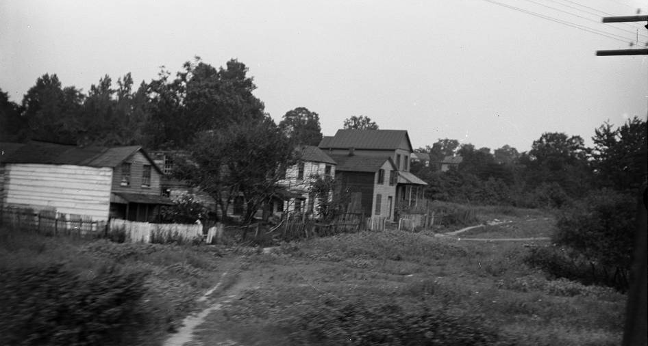
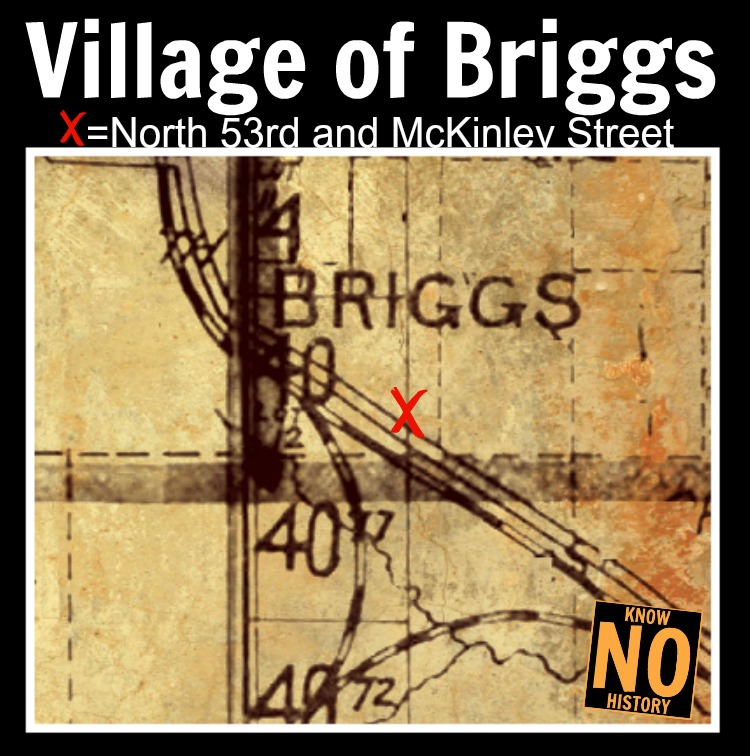
Established in 1885, the village of Briggs was a layover between Florence and Calhoun. With a post office established in April 1892, Briggs was named in honor of local judge Clinton Briggs who was also former mayor of Omaha. Briggs was also one of the incorporators of the Omaha and Southwestern Railroad. Located between Garvin Street on the south and Highway 36/McKinley Street on the north, from North 53rd on the east to North 64th on the west. Briggs added a post office in 1892 that was open until 1913. The Chicago and Northwestern Railroad went through it, and there was a school there as well. It may have been known as Mannering as early as 1870, too. It was a small railroad flag station northwest of Florence, and did not appear on the regular time tables from the railroad company. There were only an occasional train stops there for passengers, and freight was shipped regularly, and now the village is completely missing. The Briggs post office closed in 1913, and only the streets of the village remain today.


Missing Missing Towns?

Briggs Nebraska
The village of Briggs, Nebraska was located at North 53rd and McKinley Streets.

I began my search for North Omaha’s missing towns more than a decade ago. I hunted down names of schools, found old churches and looked for anything amounting to settlements throughout North Omaha, which I regard as anything north of Dodge and east of North 72nd Street. Since then, I’ve discovered names like Beechwood, West Saratoga, Cutler’s Park, and Springville. Maybe those are North Omaha’s missing missing towns?

They aren’t.

I’ve discovered that Cutler’s Park amounted to less than 2,500 lost souls looking for a good place to live – for less than three months. Surely, they had roads that were loosely graded, blocks designated, a school, a store and other places necessary for settlement, but the Mormons encamped here were forced to move just 12 weeks after getting there. When they abandoned the area, they left no marks. It eventually became part of the Brandeis family’s summer escape called Arlena Lodge. Today, there’s a memorial for the settlement just north of Young Street on Mormon Bridge Road.

After researching Beechwood for all these years, years, digging through reams of the Omaha World-Herald and the Omaha Bee, I’m willing to say now that Beechwood was no more than a school that was moved there which was originally located at East 14th and Fort Streets. It was moved to JJ Pershing and Read Street in the 1920s, and merged into OPS in 1948. There are aerial photos that clearly show no town in the location given on Wikipedia and other modern maps.

There was a community north and west of Florence called Elkhorn Junction that had its own railroad station on the Chicago and North Western Railroad.

Finally, Springville was an alternate name for DeBolt that never took off.


North Omaha Lost Town Tour

  • Briggs—Located at N. 53rd and McKinley, the only signs of the former village are the streets that follow the 1883 street grid laid out here.
  • DeBolt—Located at N. 60th and Girard, Springville School was originally built for this village. There are several pre-1900 in this neighborhood, too. For more info, read A History of the Town of DeBolt, Nebraska.
  • Florence—The original 1846 Winter Quarters Town Square is now called Florence Park, and is at N. 30th and State. For more info, read A History of the Town of Florence, Nebraska.
  • Benson—Founded in 1887, the downtown starts at N. 60th and Maple St. Benson includes the Benson Acres and Benson Gardens. For more info, read A History of Streetcars in Benson.
  • Saratoga—Established at N. 24th and Grand Ave, this town wasn’t built to last when it began in 1854, but the neighborhood has survived. For more info, read A History of the Town of Saratoga, Nebraska.
  • East Omaha—Located east of Abbott Dr and Locust St, after suffering fits and starts, the town of East Omaha was taken over by Omaha and erased from the map. Literally. For more info, read A History of the Town of East Omaha

You Might Like…


Comments

26 responses to “A History of the Lost Towns in North Omaha”

  1. Sherese Johnson Avatar
    Sherese Johnson

    What are the cities & villages you’re speaking of?

    1. They’re all towns and villages: DeBolt, Saratoga Springs, Briggs, Florence, East Omaha and Benson. They’re all between the river and N. 72nd, from Locust north to the Ponca Hills. I explore all SIX of them in the article Sherese – check it out above!

      1. Gary Bowen Avatar
        Gary Bowen

        Adam,
        I live next to Omaha Country Club and write articles for the OCC newsletter. I am attempting to do some research on trains routes that ran through what is now the Omaha Country Club golf course. There is evidence of two separate tracks (raised embankments, trestles, etc.). Could you shed any light on what these lines were and where they went?
        Dennis Mihelich and I did a history book on OCC.
        Gary Bowen

  2. Loved reading these articles. I lived in Omaha for nine years. Loved the city. Love to read history. You did a great job.

  3. Barbara Rican Avatar
    Barbara Rican

    Thank you, Adam. Your history lessons are AMAZING. I appreciate everything you do.

  4. Jim Rogers Avatar
    Jim Rogers

    Hi Adam–

    I have some questions on the location of Briggs. On this page you say it was on McKinley between 53rd and 64th. That’s a pretty long swath for such a small town and it doesn’t really match the streets at about 53rd that you say represent the original town.

    On the North Omaha Railroads comments page, you say it was at 60th and Rainwood.

    I have looked at a lot of historical plats, and it’s not easy to locate the town. E.g., in plats from 1909 and 1913 of the Florence township, the word “Briggs” is located northeast of 60th and McKinley on a plot with no other label. (Note that the west side of 60th street is Union township, and I’ve never seen anything labeled “Briggs” on any plat for that township.)

    On the 1920 plat of Florence township, the word “Briggs” is located in the same place (i.e., the northeast corner of 60th and McKinley), but now it’s over a plot labeled “North Side Addition.”

    The 1925 plat shows the same plot labeled “North Side Addition,” but “Briggs” does not appear.

    The 1938 plat shows the plot changed from “North Side Additions” to “Sundry Tracts.”

    A 1956 map shows the construction of the new McKinley road, and at 60th street it appears that they moved McKinley a bit north, and there is a town marker dot labeled “Briggs” on the south side of McKinley.

    Note that in all these plats I could not find anything indicating that Briggs was anywhere near 53rd St. All of that land appears to be owned by “J. P. Brisbine” and I see no indication of any towns.

    Based on all this, I’m thinking that the historical Briggs was located just northeast of the old 60th and McKinley intersection and that site is now southeast of the current intersection. In fact, I think the new McKinley goes right over the site of the old town, and thus there may be no remnants of it left at all.

    Just my armature research– open to input on all of it.

    1. Its not bad research Jim! I’ll help this along and put together an article with what I have about Briggs soon. I’ll put the URL here when I’m done!

      1. Jim Rogers Avatar
        Jim Rogers

        Great– thanks!

    2. Gary Bowen Avatar
      Gary Bowen

      Jim,
      I am doing some research for an article on railroad lines that passed through the Omaha Country Club golf course. I live next to the course and write article for the OCC newsletter. There is evidence of abandoned tracks that run through the course. Do you have any information about what these lines were and where they went?
      Gary Bowen

      1. Jim Rogers Avatar
        Jim Rogers

        Sorry for the delay in this response! I don’t really have any more/other information than Adam has already provided on this site.

        The line is clearly visible just a stone’s throw east of 66th and State. You can see at that point where it crossed from the north into the golf course, and there is a raised rail bed just to the south of State St. (on the golf course property).

        Would love to read the article you are writing when it’s done– please post the link!

  5. Jim Rogers Avatar
    Jim Rogers

    Also note that I don’t think SD 32 on the 1884 map is Briggs. That’s quite a ways north along the railway, I think north of the “south cut” for the track. If I had to guess I would say that school is at the intersection of what is now 60th and Northern Hills.

    It’s more likely that Briggs was closer to where the track turns north (i.e., south of SD32).

  6. Jim Rogers Avatar
    Jim Rogers

    Question: What does the picture at the top of this page show?

    1. From the Durham, this is a picture of an unnamed town in Douglas County circa 1910. I felt at liberty to put it here, given that it could have been any of the several towns in this article…

      1. Jim Rogers Avatar
        Jim Rogers

        I see– thanks.

  7. Jim Rogers Avatar
    Jim Rogers

    More info on Briggs.

    I found a number of stories on the (infamous) Nethaway murder (described here: (https://history.nebraska.gov/blog/historical-roots-george-floyd-protests-nebraska) and here: (https://history.nebraska.gov/blog/did-claude-nethaway-murder-his-wife-and-frame-innocent-man) in the Omaha Bee.

    There are a number of stories in the Bee about the murder (and the framing of a black man, Charles Smith), which you can see here: (https://chroniclingamerica.loc.gov/search/pages/results/?state=Nebraska&date1=1789&date2=1963&proxtext=Briggs+Station&x=0&y=0&dateFilterType=yearRange&rows=20&searchType=basic), and Briggs Station is mentioned prominently.

    Turns out the Claude Nethaway owned land just west of the south cut, which is said in the articles to be right near Briggs Station. You can see the Nethaway property clearly labeled in this 1913 plat:

    http://www.historicmapworks.com/Map/US/43482/Jefferson++Union++Irvington/Douglas+-+Sarpy+-+Washington+Counties+1913/Nebraska/

    The stories mention that the Briggs Station operator (Carl Herdman) and his wife could hear arguments coming from the Nethaway’s house. Also, Mrs. Nethaway was walking the tracks through the cut to the bridge (where the old McKinley road takes a sharp turn west and goes over the tracks that are down in the cut) where she was to meet her husband. Mr. Nethaway went to Mr. Herdman at the Briggs Station and they both went up the track a bit to find his murdered wife at the south end of the cut.

    Not only does this establish that Briggs Station was at the corner of 60th and McKinley (as I stated earlier), but one of the most important events in early racial strife in Nebraska originated there!

    Final note: I’m beginning to wonder if there even was a town of Briggs at all. There certainly was a station at that location, but no evidence in any of those articles of a town.

    In several articles there is mention of land for sale “near Briggs Station,” a bike club ride “to Briggs Station,” and the burning of a barn “near Briggs Station.” I didn’t run into anything mentioning a town of Briggs.

    I’m starting to think there was only a train station and post office– no actual town. But if there was a town, I think we can rule out the 53rd St location.

    1. David Ramsay Avatar
      David Ramsay

      My family were members of Florence Presbyterian Church from 1050 to 1962. My father taught my Sunday school class in the Mitchell house. The story at our church was that it was Brigham Young’s house from the Winter Quarters era. I visited the Mormon pioneer cemetery frequently at the top of North Ridge around 34th and State Street

    2. Jim, you wouldn’t be the first to suspect this, and I think by any formal measure we won’t find enough evidence to prove a town ever existed. However, it was a typical country town in that there was a post office, a train depot, and churches with a cluster of houses around them. German farmers and others clustered there, so it might be that Briggs would be best considered an ethnic colony—but I’m still looking for more evidence before declaring that!

      1. Jim Rogers Avatar
        Jim Rogers

        Great– can’t wait to see what you find!

      2. Jim, its all as terrible as you suspected. You can read the piece now at https://northomahahistory.com/2023/02/15/the-case-of-larkin-mccloud/

  8. Dorothy Henderson Avatar
    Dorothy Henderson

    love your articles on north Omaha ne. history My family lived by carter lake for many years and so much has changed We lived on north 7th st. between Hartman and Jaynes and many houses and farms are now gone .Its really sad to see neighborhood now gone and in disarray

  9. David Ramsay Avatar
    David Ramsay

    I enjoyed seeing the photos you posted of Florence. I grew up at North 30th and King Streets in the 1950s. I attended Florence Elementary on North 31st Street, and the Florence Presbyterian Church on North 31st across the street from Florence Park. In the 1950s the Church included an old house that was thought to have been Brigham Young’s home during the Winter Encampment. I have seen pictures of the house captioned as the Brigham Young home. Thank you for the memories.

    1. Thanks for your kind words! Sounds like you’d be interested in my complete history of the house itself David, which was /properly/ called the James C. Mitchell House. Its waiting for you with pics, architectural drawings, and details at https://northomahahistory.com/2017/08/15/a-history-of-the-james-comey-mitchell-house-in-florence/

      1. Deby R Arant Avatar
        Deby R Arant

        Yes, my cousin Pastored the Florence Presbyterian Church and had a picture of the house, a tree grew through the porch.

      2. Hi Deby. You’re talking about the Mitchell House. If you’re interested in it’s history and seeing pics of the tree, check out my article at https://northomahahistory.com/2017/08/15/a-history-of-the-james-comey-mitchell-house-in-florence/

  10. Ronald Potter Avatar
    Ronald Potter

    Well Adan I say another great article. You keep all the history very much alive for us. And remind us of places that many of us didn’t even know existed. I very much appreciate all the articles that you have added on online for us all to read. I’m sorry I haven’t got out and taken more pictures for you I’ll try my best to get a few more pictures to help you out . I am happy to be a friend of yours and help you out out in any way that I can. just let me know there’s something I can help you with and in the future ? your friend Ronald Potter

Leave a comment