
In the 1860s, farmers were flocking to homestead land around Omaha City. Spreading around the city, the area immediately north and northwest of the city was snatched up by speculators, mostly focused on the area north of Dodge, west of North 30th Street, and east of North 60th. Way out from Omaha was a farming community that became known as the village of DeBolt, Nebraska.
The 1862 Homestead Act around Omaha
Omaha City was founded in 1854. Serving as the Nebraska Territory capitol until 1867, the city was a hotbed of political power in the pioneer era. It was through this lens that the first Homestead Act had a huge impact on Nebraska when it was passed in 1862.
President Lincoln signed the Homestead Act authorizing any citizen to settle on any surveyed but unclaimed 160-acre tract of public land. If settlers made the specified improvements to the land and paid a small fee, they would gain full title to the property after five years.
Within a year, the area around the city was largely claimed by a mix of wealthy land speculators and small-time farmers.
Homesteads – which were 160 acres – were given by the US government to citizens who settled on the land and farmed the land for at least five years. Homesteaders had to:
- File an application;
- Improve the land with a house, barns, farming or otherwise; and
- File with the government for a deed of title.
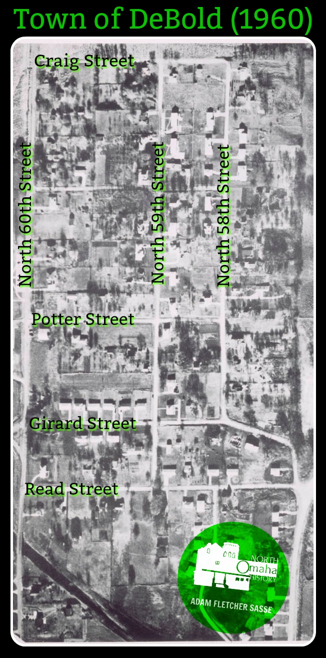
A community of farmers, including homesteaders and those who bought from previous homesteaders, gathered around present-day North 60th and Girard Streets relatively quickly. One of the families that owned a large farm belonged to George M. DeBolt (1845-1914). DeBolt was a former Union Pacific employee who lived at the development named for him for 46 years, and was buried at Mount Hope Cemetery near Benson.
The Local Population

A mercantile was established near the area soon after. In the late 1860s, a school was built out in the countryside in the same area. A local taxation area was started and called District 29, and the Springville School was built by 1872. According to Omaha Public Schools, the first Springville School was built on what was to become 66th Street between Redick and Girard.
In 1884, a new Springville School was built at the previous location as a two-room schoolhouse. The old school was sold to the Debolt family and converted into a house a short distance north of present-day Sorensen Parkway. Not a lot of other noted events happened around Springville School for several years. Farms are built up, sold and new farmers come into the area. Along with large haying fields, barns and paddocks filled with chickens, pigs and horses dot the landscape. There are also a number of large gardens and orchards, where vegetables, fruits and nuts are grown to be sold in downtown Omaha in what we know as the Old Market.

In the 1880s, a colony of Scandanavians began around the Springville School, and clustered throughout the immediate area. Farm families in the area included the Andersens, Boisens and Nielsens, and many others. In 1889, the Springwell Danish Cemetery was formally opened. Located at 6326 Hartman Avenue in the Hartman neighborhood, its approximately a mile south of the Springville School. Dating from the earliest era of its existence, today there are still several tombstones in Danish, and it is one of the few remaining urban Danish cemeteries in the United States.
A recent note from Galen Lillethorup, the former president of the Springwell Cemetery Board of Trustees, says this about the cemetery:
“You may find it interesting that for a brief time the Springwell Cemetery was named Springville. The first meeting of the Board was on February 6, 1889 and until April 3, 1889 meeting reports simply referred to it as “the Danish cemetery.” According to the notes for the April 3 meeting, “a Board member learned that the school district around the cemetery was called Springville. He moved to have the cemetery named Springville. The motion passed.” It wasn’t until the meeting of June 4, 1890 that the Danish cemetery Board decided to call the cemetery Springwell.”
There is also record of the “DeBolt Preaching Station” used in the town during the 1890s by both Methodist and Lutheran ministers. The Missouri Synod counts Rev. Otto Erbe as having taught classes there.
Tragedy struck the area in 1891 when E.B. Owen, the agent at DeBolt Station, was killed by accident. Driving a railway tricycle to visit his brother, he was headed to Irvington when he came behind a train at a standstill. Backing up unexpectedly, Owen attempted to backup but couldn’t go fast enough. He was driven over by two trains and died soon afterward.
In 1893, a DeBolt farmer called Mrs. Chapman brought a basket of grapes to the Omaha World-Herald office in downtown Omaha. According to the newspaper, these grapes “closely resemble in sweetness and delicacy of the flavor of fine grapes of Germany, while in color they are like the white grapes of California.” This led the newspaper to pronounce that, “Nebraska can evidently grow grapes of the choicest variety and most delicate flavors.”
In the 1890s, Mr. and Mrs. A. A. Gibson kept a spread at “Shady Kenmere” at DeBolt. They were frequently cited in the Omaha World-Herald “In Society” section, hosting parties and dinners and out-of-town visitors from Omaha, Illinois and other places in the eastern U.S.
A man named James Ellis operated a newsstand and grocery store at DeBolt for a number of years in the 1880s and 1890s.
A Railroad Town Starts

As early as 1887 developers were hocking land under the banner of DeBolt. With the opening of DeBolt Station in 1888, the area north of Whitmore Street was developed as the village of DeBolt. A post office called Debolt, Nebraska, was established in 1892 and remained in operation until 1899.
While some sources refer to the site as merely a junction point (see below), there’s ample record of multiple establishments and several houses in the surrounding area. Billed as “three miles west of Fort Omaha and two miles north of Benson”, it was cited in the newspaper from the 1880s through the 1930s.
A literary society started meeting in DeBolt in 1896, and reportedly continued meeting for more than a decade. From the sounds of it, they were essentially a book club.
In December 1895, the DeBolt community was rocked by scandal when four 13-year-old boys were charged with stabbing a 12-year-old at the DeBolt School. When the defendants were narrowed down to one stabber, the Omaha World-Herald reported that “both boys were of respectable families.” When the attacker was found guilty, a fine was levied against his family and he was released to his parents.
In 1899, a group of men working for the Fremont, Elkhorn & Missouri Valley Railroad returned to the section house to find a naked man throwing around their supplies inside. When they tried to go in, the man started through iron strips, bolts and tools at them. As they called the sheriff to come, the villagers gathered around the shop. He arrived with several deputies, and they harnessed the man in a straightjacket. Everyone there said they’d never seen the man before, and he was hauled away to the county jail in downtown Omaha.
In addition to the section house, there was a siding at DeBolt, too.
To give you a sense of the land values in the area, in 1911 eighty acres of farmland near DeBolt was offered for sale for $10,000. The amenities of the location included its proximity to DeBolt and the Brandeis farm. This property presumably sold. In 1912, Brandeis sold his country home and farm, which included 290 acres. One of its selling points was the fact that it abutted the “village of DeBolt.” Fred Parker, inheritor of the massive Parker Estate, sold 80 acres immediately northwest of DeBolt in 1912 for $10,000.
In 1913 the CNW was sued to install livestock shipping facilities at DeBolt Place by a local rancher. He contended that since this type of facility was there in the 1890s when he first opened his operation there, the CNW should be required to continue them there. His case didn’t succeed, as didn’t another case in 1918. That year, a local resident sued to have an underground crossing beneath the railroad built at DeBolt. He lost.
Starting in 1916, the Debolt Place Improvement and Political Club met monthly at the Debolt School. After the school was rebuilt again in 1917, there is no further mention of the club meeting.
In 1919, a local man was denied a permit to create a garbage dump for Omaha’s trash near DeBolt. The man was feeding his pigs and chickens with the city’s trash, and his neighbors were disgusted by the sight and smell of this practice. He was ordered to stop bringing trash there, and eventually moved his farm north and west of DeBolt so he could continue.
In 1920, a US government geographic survey noted that DeBolt should not be mistaken as “De Bolt Place, DeBolt Place, nor De Bott.”
In 1926, the Chicago and Northwestern Railroad announced plans for a second belt line rail line in Omaha. Launching west from Fort Omaha, it was intended to go toward Forest Lawn Cemetery, DeBolt Place and Benson. From there it would go towards North 72nd and Dodge, then southward to Aksarben.
In the 1930s, a court case established that the CNW was charging shippers entirely too much at the DeBolt Station. That case succeeded, and the railroad was forced to lower its prices.
In 1948, a new two-room brick school was built on the present-day location of Springville School at North 60th and Girard Streets.
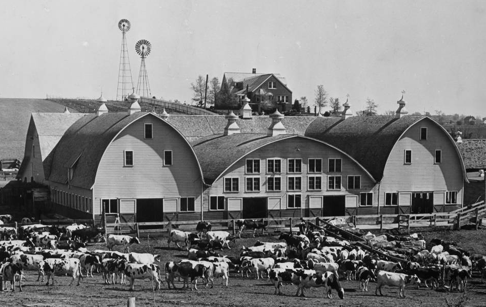
Sorensen Dairy Farm

The Sorensen Dairy was established by George E. Sorensen in 1918. Buying a section of land from North 66th on the east to North 72nd, from Hartman on the south to Girard on the north, Sorensen was a neighbor of Debolt Place, although the two places weren’t associated. George’s son, Clarence, and his wife Sofia helped run the farm starting in the 1950s. The house and barn were located at North 66th and present-day Hartman Avenue, which was originally called Redman Road.
In 1966, the Sorensens sold their dairy, and in 1967 the Immanuel Hospital bought the land. Apparently the Omaha Fire Department burned down the old Sorensen barn as practice for fire fighting that year.
Connected with many of the pioneer Scandinavians who’d settled in the area back in the 1880s, fairy farmer George Sorensen (1857-1936), his first wife Lena Sorensen (1856-1921) and his second wife Frances Sorensen (1861-1947) were all credited with running a large and successful operation for a long time. Today, the Immanuel CHI complex continues to operate on the original site of the Sorensen Dairy.
Railroads through DeBolt

According to John Peterson, a local train guru and writer, the Fremont, Elkhorn and Missouri Valley Railroad (FEMVRR or Elkhorn Road) built a line from Arlington to Omaha in 1887. Towns and villages along the railroad from Fremont to Omaha included Arlington, Bennington, Washington, Irvington, DeBolt and Omaha Heights.
John says the line split in Irvington with one branch going east toward Carter Lake to connection with the Omaha Road. Its passenger trains used the Omaha Road to access the Webster Street Station. The other line went southeast to South Omaha and the stockyards. The Chicago and Northwestern Railroad (CNW) bought the Elkhorn Road, and in 1903 the CNW obtained trackage rights over the Union Pacific between South Omaha and Union Station and its passenger trains moved to Union Station.
In the late 1880s, the Chicago, St. Paul, Minneapolis and Omaha Railway or Omaha Road came through the village of Briggs, about two miles north and east of the Springville School near the present-day intersection of McKinley and I-680.
A line was built between the Omaha Road in Briggs and the CNW line near present-day North 60th and Whitmore. Around 1888, the DeBolt Station was built near the junction. It was never a large station, but it was more than a cattle stop for shipping cows to the stockyards. Receipts for 1917 showed that the station sold just over $500 in total freight charges and passenger tickets, compared to more than $14,000 at nearby Bennington. There was also a section house at DeBolt, which was a building next to a section of railroad used for housing railroad workers and to store equipment.
Arthur Brandeis, a scion of the Brandeis Department Store family, built a country estate north and east of DeBolt after buying an old farm in 1916.
In 1926, the Chicago and Northwestern Railroad (CNW) connected in DeBolt, then was extended to connect the Omaha Road with the Omaha Stockyards and the Union Pacific mainline. The World-Herald excitedly declared that DeBolt was on the “outer belt line,” a train loop for shipping, to differentiate it from the Belt Line Railway. Extending from Fort Omaha to DeBolt, it continued almost to Irvington and then south near 72nd Street, across Dodge and to Ak-Sar-Ben. Predicting that this move would “open up areas between Ak-Sar-Ben Field and Fort Omaha” for development, the railroad had high goals. CNW owned the land around 72nd and Dodge and thought it would develop immediately and lavishly, also expecting factories and warehouses to spread across this region of northwest Omaha.
The Omaha Country Club built a lush new clubhouse nearby in 1927, where it continues standing today.
The End of Debolt
Starting around 1884, when the DeBolt Place lots started going for sale, the DeBolt Station was opened on the railroad, and a new Springville School was opened, the little settlement seemed like a going concern. However, that was mostly over by 1926, when lots in DeBolt Place stopped being advertised, the DeBolt Station closed and other mentions of the area dwindled in local newspapers.
John Peterson says the railroad line through DeBolt was the first CNW rail in Nebraska to be abandoned. By the 1950s, the area around DeBolt Place was annexed into the Omaha city limits. Houses, churches and businesses were developed nearby, and in 1958, District 29 merged into Omaha Public Schools. Springville School continued to exist though, and after several additions they built a new building for the Springville School that opened in 2007.
David Seidel wrote a book on the Fremont, Elkhorn & Missouri Valley Railroad. According to him (via David Budka), in 1971, the CNW abandoned the railroad from Arlington to Bennington, and in 1976, the Bennington to Irvington section was abandoned. The section from the Omaha Road Junction (aka DeBolt) to Irvington was abandoned the next year.
DeBolt slowly lost any identity it might have had. There was a whistle stop sign on the railroad, but by its end, the old area where the station used to be was simply called the Omaha Road Junction. With the introduction of the interstates around Omaha in the 1950s and 60s roads, along with heavier trucks capable of carrying heavier loads, many lesser known lines and spurs around the city were lost. The 1920s influx of housing and factories along the Outer Belt Line Railway didn’t materialize, and the CNW line through northwest Omaha seized to operate in the early 1970s. It was formally abandonded in 1977.
The region along the old CNW along with DeBolt was slowly developed into suburban tract houses and strip malls.
Remains of DeBolt
Today, Omahans can pay homage to the old railroad that led to DeBolt by driving on Sorensen Parkway from North 60th west to was the old connector between the Omaha Road and the Elkhorn. I thought it was further north.
The Omaha Country Club is a private country club that was established in 1899. When its original location became desirable suburban development property, the group relocated to an area west of DeBolt and north of the Sorensen Dairy in 1925. The organization continues there today, and doesn’t recognize its past connection with the little village that was its neighbor. However, its tiny next door neighbor in the southeast corner of its section still bares the name its had since the 1890s: the Springville School.
The Springville School, which sits on the corner of North 60th and Girard, is the anchor for any remaining memories of the village of DeBolt. Long gone is the railroad, which traveled northwest from North 56th and Mary Street to North 60th and Whitmore, and then along Girard from approximately North 63rd westwards.
Cell Phone Location
When online mapping started in the 1990s, many of the companies used old plat maps that showed DeBolt. When that technology morphed into the popular mapping apps like Google Maps and others, they simply repeated those early maps. Today, Debolt, Nebraska or Debolt Place show up on many users’ phones. Unfortunately, this has misled many people into thinking that Debolt covered the entire Omaha Country Club property or included the Sorensen Dairy. No matter what those maps show, DeBolt DID NOT include either of these properties. Instead, it was just the small area around North 60th and Girard.
Sorensen Parkway
Starting in the 1980s, trackage was removed from the CNW. In 2001, the City of Omaha and other government partners declared a new road called the Sorensen Parkway open, ushering high speed traffic past the former sleepy DeBolt Place development. Extending from Fort Omaha on North 30th to the commercial intersection at North 42nd and Redman, Sorensen Parkway made DeBolt blend into a five mile stretch that includes Roncalli Catholic High School and Pinewood Elementary School to the former Northhampton Mall on North 56th Street and the new Immanuel Medical Center at North 72nd Street.
The parkway was named for Alexander “Axel” V. Sorensen (1905-1982), a former mayor of Omaha, is the namesake of the parkway and not George Sorensen, who was the dairy farmer with a large operation at North 72nd Street.
No Plaques
The last remnants of DeBolt today are the grid pattern of streets from Craig on the north to Whitmore on the south; North 56th on the east to North 60th on the west. These streets formed the nexus of the village, although almost none of the homes are original. There seems to be no memory of this town among the people who live there. But at one time, this was a sleepy little station on the Elkhorn Road with farms all around, a bunch of Scandinavian farmers nearby, and a quick train ride into the big city of Omaha.
Today, no historical markers exist in this location and there is no formal acknowledgment or designation for its historical value.
You Might Like…
MY ARTICLES ABOUT HISTORIC NEIGHBORHOODS IN NORTH OMAHA
National Register of Historic Places Historic Districts in North Omaha: 24th and Lake Historic District | Benson Downtown Historic District | Country Club Historic District | Dundee/Happy Hollow Historic District | Fairacres Historic District | Fort Omaha Historic District | Minne Lusa Historic District | Nicholas Street Historic District
Historic Neighborhoods in North Omaha: Bedford Place | Belvedere Point | Bemis Park | Benson | Briggs | Bungalow City | Carter Lake, Iowa | Central Park | Clifton Hill | Collier Place | Creighton University | Crown Point | DeBolt | Druid Hill | East Omaha | Fairfax | Florence | Florence Field | Fort Omaha | Fontenelle View | Gifford Park | Gold Coast (Cathedral) | High Point | Jefferson Square | Kellom Heights | Kountze Place | Lakewood Gardens | Little Russia | Long School | Malcolm X Memorial | Miller Park | Miller Park Duplex Historic District | Monmouth Park | Montclair | Near North Side | North Downtown Omaha | Omaha View | Orchard Hill | Plum Nelly | Prettiest Mile in Omaha | Prospect Place | Raven Oaks | Redman | Saratoga | Sherman | Squatter’s Row | Sulphur Springs | Ponca Hills | Wakonda | Walnut Hill | Winspear Triangle | Wyman Heights
Lost Towns in North Omaha: Benson | Briggs | DeBolt | East Omaha | Florence | Saratoga | Sulphur Springs
Elsewhere Online
- Springville School Centennial Program (A History of the School)
- History of the Omaha Country Club official webpage
Bonus Pics!


Leave a comment