
Now seen as the front door to Omaha, Cuming Street has also served as the city’s farthest edge; as the growing, mighty muscles of industry and business; and as its dirty, neglected backside. This is a history of Cuming Street in North Omaha.

Named For Who?

Thomas B. Cuming happened to be the right guy in the right place at the right time. Twice. The first time, Cuming became the acting governor of the Nebraska Territory after Francis Burt died after just two days in office. Cuming was just 25 years old and was originally assigned Secretary of the Territory by President Franklin Pierce. During his four months in office during this term, Cuming essentially started the north-south battle in Nebraska by awarding Omaha the capitol and giving the counties north of the Platte River the majority representation in the Territorial Legislature, despite having merely 1/3 of the territory’s population.
The second time he was acting governor of the territory was after Mark Izard resigned suddenly after serving just two of his four-year term in office. Just before this, the southern Nebraska counties almost broke off from the territory to join Kansas; Cuming did nothing to stop this. The second time he served just 2 1/2 months in office.
Honoring the Dead
Cuming died suddenly in 1858 at the age of 30. His untimely demise was met with praise for his dedication and perseverance in the upstart territory, and in addition to the county that was named for him, Omaha’s city leaders dedicated a great street in his name.

Originally called Badger Street, the path that became Cuming Street was much older than Omaha City or the Nebraska Territory, which was founded May 30, 1854. Instead, Cuming Street started as a remnant of the old Military Road, which itself followed the Whitman Trail, created by Narcissa Whitman in 1836. Later called the Mormon Pioneer Trail and the Council Bluffs Road, the Oregon Trail connected to it west of Omaha by the 1840s. Writing about the road, the Nebraska State Historical Society said,
“The ridge line segment of the Military Road relates to 1856. The segment was probably in use through the 1860s. Supplies from the Missouri River landings to the frontier the earliest development and layout of the route. The road was originally utilized for movement military posts to the west.”
—Nebraska State Historical Society

Military Road was originally laid out in 1857 by Captain Edward Beckwith for the U.S. Army. When Omaha’s city planners began their pursuit of growth, they simply laid out their streets to align the roadway. When Badger Street got all the way west to 24th, then called Saunders Street, they simply connected it to the Military Road leading west and northwest out of town.

After Cuming died early, city leaders decided to rename this roadway in honor of their lively young leader. Cuming Street was named for him by 1866.
Early Growth

When they came through the area in 1804, Lewis and Clark found a large village of earthen lodges covering the plateau between North 16th and North 30th from approximately Cuming north to Hamilton Streets. Originally, Badger Street was at the very northern edge of the map of Omaha City.
The North Omaha Creek, surveyed as the northern boundary of Omaha in the city’s first map, flowed where the present-day intersection of North 24th and Cuming Streets is located. Only strangers and old cowpokes lived up there, and few people went that way, and it was almost that way for a decade.
When Cuming Street started growing, it was a mix of business and houses. The neighborhood between North 17th and 20th, from Cuming south to Cass was founded as an Irish neighborhood in the 1860s. Holy Family Catholic Church was the neighborhood’s Irish church, with Irish priests who founded Creighton University.
Around 1865 a bridge was built at North 25th and Cuming Street. Called the Military Bridge, it was constructed by US Army troops who needed a faster route to join the Oregon Trail, which started at North 30th just north of Cuming. The bridge was needed to cross North Creek, which waggled across Cuming Street and flowed through a swamp around the area. Even though it was referred to as the “old bridge” as early as the 1870s, it was used into the 1890s.
By the early 20th century the area was an Italian neighborhood, with Holy Family serving then as an Italian parish. North 19th and Izard was the location of the North Omaha School, which was open in 1874.
However, it wasn’t known as a great place to live. Instead, as an 1898 city history exclaimed, “it is fitting that Cuming Street should have become a lively business thoroughfare, thus truly typifying the young governor.” Lively it was!

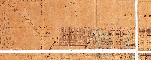
Starting at North 8th Avenue, Badger Street shot west to North 16th Street from the inception of the city. In 1860, the City of Omaha handed out lots to Nebraska Territorial legislators to keep the capitol in Omaha. The area they drew from ran from the Missouri River to N. 30th Street, Cuming to Lake St., and was called Scriptown.
However, despite being popular and almost all legislators taking some, most of these lots were never developed.When Tom Cuming died in 1868, Badger Street was renamed for him. Proving its importance, the first line of the Omaha Horse Railway was built in 1868 from 9th and Farnam Streets to 20th and Cuming Streets.

In addition to the city’s first horse-drawn streetcars, Cuming was also home to the city’s first electric streetcars, too. Before 1905, Cuming Street heading west from North 30th was called Mercer Street. That year, recognizing the importance of common naming and of Cuming, the entire street was renamed. Dr. Samuel Mercer began running streetcars up his self-named street in the 1880s to attract people to the beautiful housing addition he was building at the top of Cuming at North 40th Street.

Cuming Street continued to grow in importance. Establishing itself as a major east-west road, Cuming became more and more busy.


In those early years, there were a lot of different kinds of businesses all along Cuming, from North 10th all the way up the hill towards Mercer’s Mansion. Large commercial bakeries and car garages, along clothing and bedding manufacturers were up the street from the Ford Plant, while professional offices and apartment buildings crowded corners with taverns, restaurants and more.

The first uniform grade for Cuming Street was established in 1881, when James Boyd was mayor of Omaha. Recognizing the elevation of the street was difficult for its purposes, the City of Omaha established a routine grade leading to North 23rd Street and beyond.Social halls on Cuming in those early decades included the Marathan Hall at North 25th and Cuming, and Sander’s Hall at North 24th and Cuming.

Historically, there were several faith communities located along Cuming. These communities lent themselves to ethnic groups, too. For instance, they included two German-speaking churches: First German Presbyterian Church at North 18th and Cuming Streets, which opened in 1882; and Salem Church at North 18th and Cuming Streets, which opened katty corner in 1904. The Greater Beth-El Temple was established at North 24th and Cuming in 1952. B’nai Jacob – Adas Yeshuron, also called “The Kapulier Shul”, was incorporated on North 19th Street in 1909, and had a location at 3028 Cuming Street for a number of years.

From the 1870s to the 1920s, the second largest ethnic group in Omaha were the Irish. They settled in all parts of Omaha, but were found most commonly in an area along the western edge of the Union Pacific Shops at Cuming Street and extending north along 16th Street. They attended the Holy Family. Before 1919, there was a large Black population south of Cuming. Other ethnic groups around eastern Cuming Street during this era included northern Italians, Chinese, Scandinavians, Jews and others.

Cuming Street was the historical southern boundary of Omaha’s segregated Black neighborhood. Concentrated between Cuming and Lothrop, 16th and 30th from 1919 through the 1960s, African Americans were prohibited by redlining from moving outside that district. Between federal and state laws; bank lending procedures; real estate practices and insurance company policies, African Americans weren’t allowed to move beyond these boundaries until the 1960s.
Cuming Street Historical Sites

There are a lot of landmarks along Cuming Street, beginning with its starting point at North 10th Street and Abbott Drive and flowing until its first major ending at North 52nd Street.
Historical Site 1: Union Pacific Shops

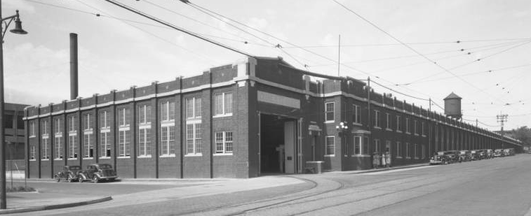
The Union Pacific Railroad Shops at North 10th and Cuming grew from necessity. As the genesis for Cuming Street for more than a half-century, the UPRR Shops made everything from the bolts to the boxcars that made the Union Pacific great. In the 1950s the site was formally expanded to cover 100 acres of property. The shops’ importance in the company lasted until 1988, when the UP moved most of their maintenance operations out-of-state. In 2000, the Union Pacific voluntarily closed down the site forever. Today, standing about 50 yards south of Cuming on North 10th Street allows people to stand at the site of one of Omaha’s greatest industrial operations and contributions to the national economy.
Historical Site 2: Tip Top Apartments

The Omaha Ford Motor Company Assembly Plant at 1514-24 Cuming Street was built in 1916 in what was then a mixed industrial and residential area. The plant had a bottom-to-top assembly process, with finished cars placed on the roof for storage before being sold. It was a Ford plant until the 1930s. In 1936, a local company called Tip Top Products took over, making liquid solder, hair accessories, and hundreds of other household goods there until 1986. After a brief stint as a tire warehouse and store, in 2005, the building was renamed in honor of Tip Top, and renovated into apartments and office space. Today, the Omaha Ford Motor Company Assembly Plant is listed on the National Register of Historic Places.
Historical Site 3: Site of Badger Body

One of the businesses that made North Omaha a great place to live was Badger Body and Truck Equipment, Inc., a company that modified Ford trucks from across the street on the southeast corner of North 16th and Cuming Streets. They also manufactured farming and construction equipment. The company moved from the intersection at some point, and today is located elsewhere in Omaha.
Historical Site 4: Near North Side

The Near North Side neighborhood runs from Cuming on the south to Locust Street on the north, and from North 14th on the east to 30th Street on the west. It is where a lot of Omaha grew up, including working class European immigrants, Omaha’s Jewish community, and for the last 80 years its served as the core of Omaha’s African American community. The historical home of the Logan Fontenelle Public Housing Projects, the area was the target of federal “slum clearance” programs in the 1930s before they were built. Demolished in the 1990s, today this area is being rehabilitated.
Historical Site 5: N. 17th and Cuming St.

Located at North 17th and Cuming, the Fitzgerald Hotel was originally built in the early 20th century. After closing in 2006, it sat empty for a half-decade. However, soon a dozen high-end apartments will open there. The wide sidewalk are being made into an outdoor courtyard with brick columns and a wrought-iron gate, and a second courtyard for renters will be behind the building. The exterior of the building is being finished with metal, glass and brick, and the interior of the apartments will be beautiful.
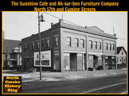
The intersection of North 17th and Cuming had a lot going on. The Booker T. Washington Hotel, one of Omaha’s several segregated Black-only hotels, was at 1719 Cuming. The Bloom Monument Building is a fine display and design building built at the intersection in 1906, and today it is a restaurant. Across the street is Grace Tabernacle Church of God in Christ at 1801 Cuming. Built in 1910, this building is surrounded by properties owned by Creighton University. The Omaha Pillow Company was located at 1807 Cuming in 1899. They “renovated feather pillows and made mattresses of all kinds”, and sold mattresses and down covers.
Historical Site 6: Holy Family
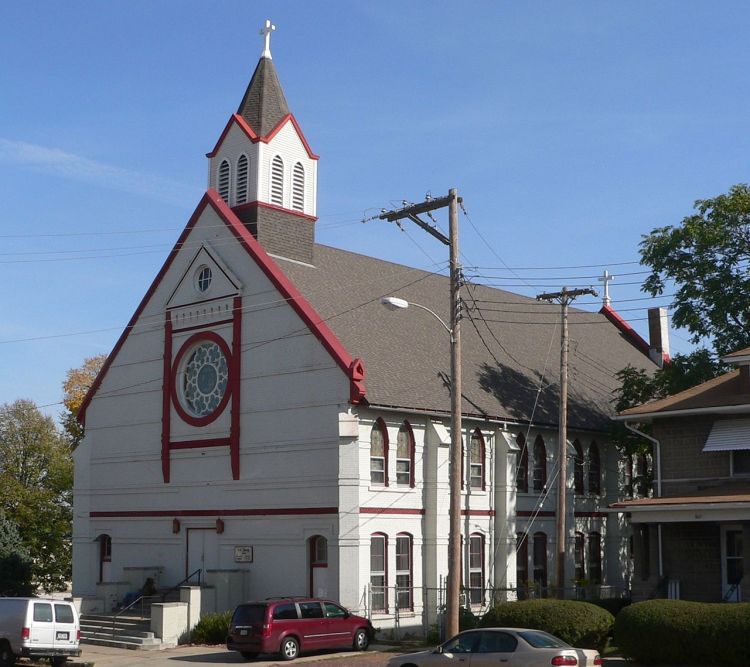
Built in 1883, the historic Holy Family Catholic Church is located on 18th and Izard Streets, a half block north of Cuming. Founded to serve the surrounding Irish neighborhood in 1883, Holy Family is the oldest existing Catholic church building in Omaha. Becoming an Italian congregation after that, and then serving the entire community for the last 75 years. Current plans by the City of Omaha will remove all of the other buildings on the block to create a traditional church square. The Holy Family Church Square will function as a public park and as a town green around while still allowing Holy Family to continue operating as a church. The church is listed on the National Register of Historic Places.
Historical Site 7: Florence Boulevard

The Florence Boulevard was originally called Winter Quarters Road when it launched five miles northward from Badger Street in the 1860s. In history, a section was also known as the Prettiest Mile in Omaha Boulevard. It saw the emergence of the North Omaha community, running through the old town of Saratoga to Miller Park and beyond. In 1898, many Omahans traveled it to get to the Trans-Mississippi and International Exposition. Today, its a pathway to some of the finest historical sites and buildings in the city.

Historical Site 8: Roberts Dairy

The intersection of North 30th and Cuming Streets has been home to a dairy since 1869. That year, Martin Tibke started a dairy there with nine milk cows. In 1882, he had “forty-two head, and employs two men, three horses and one delivery wagon. He sells seventy gallons of milk per day and has 150 customers, he has, in addition to this dairy, a farm of 200 acres, near the barracks.” The barracks were at present-day Fort Omaha at this point, so the farm was near North 30th and Fort Streets.
J. R. Roberts began Roberts Dairy in 1906 on a farm near Lincoln. The company opened its Omaha branch in 1929, and in 1981, Roberts Dairy became a division of Prairie Farms–Hiland Dairy. Today, it owns all of the buildings along Cuming between North 30th and the North Freeway.
Historical Site 9: Gifford Park
The Gifford Park neighborhood is bounded by North 30th Street on the east, to North 38th Street on the west, with Dodge on the south and Cuming Street on the north. Jesse Lowe, the first mayor of Omaha City, was the original landowner of this area. Dr. Harold Gifford, Sr. acquired it in the 1880s, and opened it for development in the 1910s. The area of 33rd and California became a busy commercial district in the 1920s and 30s, with grocery stores, an upholstery shop, dentist, a delicatessen, tavern, bakery, theatre, barber shop, and a variety store. There was also a filling station, ice house, a beauty school, garage, butcher shop and drug store. Schools in the area included Yates Elementary School, Tech High School, and the Duchesne Academy.
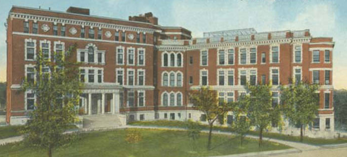
Historical Site 10: Omaha Tech H.S.

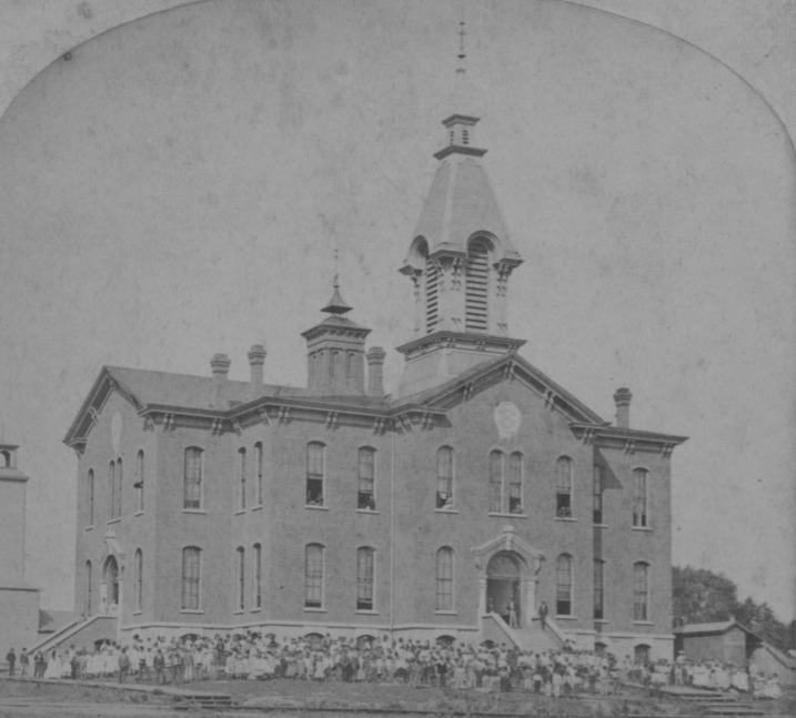
When Omaha Technical High School opened in 1923, it was the largest school west of Chicago and with state-of-the-art supplies, it was said to be the best equipped in the country. After graduating thousands of students over 60 years, the school was closed in 1984. It was repurposed into the district offices afterward. The original lobby features polished marble and ornate moldings; however, Omaha Public Schools converted the football field into a parking lot and moved the main entrance to the building to the east side, with a three story atrium greeting guests. Architects used the high ceilings in the two original gymnasiums to create two floors of office space, while leaving the original auditorium and other features largely intact.
Historical Site 11: Harvest Community Church

Originally located at North 24th and Cuming, Calvary Baptist Church opened in 1886 as a mission church. 35 years later, the church built a grand new building at North 39th and Cuming Streets. Built in a grand Gothic Today, this building is home to the Harvest Community Church.
Historical Site 14: Bemis Park Landmark Heritage District

The Bemis Park neighborhood was built to be extravagant, and its holding onto that image still today. Omaha’s first mayor, Jesse Lowe, originally owned the land. Today, its boundaries are Cuming Street to Hawthorne Avenue, Glenwood Avenue to North 33rd Street. In the 1870s, Omaha real estate mogul George Bemis built the neighborhood for business leaders, lawyers and doctors. Through the 1920s, find homes were built and maintained, even after the horror of the Easter 1913 tornado. However, by the 1940s the neighborhood was being divested in because of its proximity to Omaha’s African American community.
Split into apartments and owned by slumlords, the neighborhood fell to its knees by the 1960s. However, vigorous preservation advocates focused on saving the fine Victorian-era homes pushed for new city zoning to encourage rehabilitation, and it worked. Today, the neighborhood retains its historic relevance and awesomeness, and is a role model for many Omaha neighborhoods. The neighborhood includes a beautiful park, once home to a lagoon and now to tennis courts and a slow walkway. The Bemis Park Landmark Heritage District has been recognized as an official Omaha Landmark.
Historical Site 12: Site of Methodist Hospital
Built in 1908, the Methodist Hospital was located at 3612 Cuming Street for more than 50 years. With 128 beds initially, the building grew and grew, with the main hospital remaining there until 1968. It operated as the Midtown Methodist Hospital until 1985, when it was sold to the Salvation Army. They housed a regional headquarters and emergency facility there until 2016, when they’ve began demolition on the entire building to erect an entirely new building and eliminate any sign of its historical vibrance and significance to the city’s history.
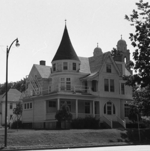
Historical Site 13: Mercer Mansion

After spending a career as a surgeon, Dr. Samuel D. Mercer decided to retire from medicine and focused on his building his real estate dynasty. In 1885, he built the Mercer Mansion, one of the finest homes in Omaha, at 3920 Cuming Street. To support the development of his real estate and make more money, Mercer financed the construction of cable streetcars in Omaha. His 23-room mansion is a great example of the Queen Anne style, with cherry, mahogany, oak, and black walnut woodwork throughout the inside of the house, and a large square tower that is four stories tall on the outside. In the late 1920s, the mansion was converted to apartments, and today it still stands guard over the neighborhood. There was also a single-story Mercer Building built at North 40th and Cuming in 1920. It does not stand anymore. Today, the Dr. Samuel D. Mercer House is listed on the National Register of Historic Places.
Historical Site 14: Walnut Hill

The entire Walnut Hill neighborhood is a veritable feast of delicious homes, businesses and historic goodness. Along with the Mercer Mansion, the Walnut Hill Reservoir offers a beautiful destination with fountains, trees and landscaping that is awesome. The neighborhood also has enormous old homes, beautiful streets and walkways, old storefronts and more. At North 40th and Hamilton, an old block of storefronts is being rehabilitated into modern, deluxe spaces for creative and economically important growth in the neighborhood. Even the old apartments in the neighborhood are visually pleasing, easily carrying visitors to the St. Cecilia Cathedral. You can also see the old Belt Line Railroad bed in the neighborhood! A veritable feast…
Historical Site 15: Gold Coast

Between 1889 and 1949 the Gold Coast Historic District grew quickly and big from roughly 36th to 40th Streets, Jones to Cuming Streets. As Omaha’s second Gold Coast, it was home to its Gilded Age warriors of business and industry. There are 30 blocks in the district, with large mansions, commercial buildings, multi-family dwellings, hotels, schools, and religious facilities. The middle class filled it in with smaller homes and multi-family units. Its architectural styles are amazing, and there are a lot of beautiful places there. The neighborhood is home to the amazingly beautiful St. Cecilia Cathedral, which is a block south of Cuming and is listed on the National Register of Historic Places. The West Central-Cathedral Landmark Heritage District is recognized by the City of Omaha as an official Omaha Landmark and is listed on the National Register of Historic Places.
Historical Site 16: Dundee
In 1905, a housing boom in the village of Dundee between 47th Avenue and Happy Hollow Boulevard led the neighborhood north along Cuming Street to being annexed by the village. In 1915, the entire town was annexed by the City of Omaha.
Lost Places


There are other notable places along Cuming Street, including the the Siena/Francis House emergency overnight shelter for men at 19th and Cuming Street, as well as the offices of Metro – the Transit Authority of the City of Omaha at 22nd and Cuming. The Bob Kerrey Pedestrian Bridge is at the point where Cuming would meet the Missouri River, and the TD AmeriPark Stadium is at North 13th and Cuming, across from the successful CenturyLink Center, which itself is in front of the Gallup campus.The Creighton University campus is expanding north to Cuming Street, and they’ve completed a new stadium on the street, too. They are building this facility to continue serving the community after the old St. Joe’s is closed in 2017. Kiewit is building a $23 million training facility at North 14th and Cuming Streets soon. Facing the Slowdown facility built in the mid-2000s, it will serve as an international draw to Omaha and is seen as a boon to the area. It was finished in 2017 and has two floors and 63,000 square feet of space.
A Huge Building Demolished
There was a three-story brick mixed-use building with three storefronts at 2702, 2704, and 2706 Cuming Street from about 1906 to 1966. Several apartments were located in the second and third floors, with the address 2704½ Cuming used. Sometimes those stores occupied more than one storefront, sometimes they used each others addresses, and sometimes they don’t line up. However, because they were all in the same building I’ll share their stories together here.
Before the brick building at 2704 Cuming Street was built, in 1888 there was a wood frame store there called Hussie’s Hardware. In the early 1890s, N.P. Sass had a grocery store at the address. His telephone number was 1361. In 1890, Bruning’s Butcher Shop was located next door at 2706 Cuming Street. The Steele-Smith Grocery Copmany foreclosed on that business in 1894 and sold the entire stock. There were Havana cigars sold from 2706 by H.J. Potter & Company later that year. A City of Omaha prosecutor named Jesse Miller lived at 2702 Cuming in 1898, as well as someone named William White. The Carpenter Paper Company was located there that year, too, and Peter Neilsen kept a billiard at this address.
Palace Grocery and Meat Market was located at 2704 Cuming in 1903, and the Palace Feed Store was located next door 2706 Cuming Street. That same year, a dentist from Council Bluffs called F.C. Clark moved into the building. Goldenberg & Hornstein Grocery Store was there the next year in 1904. The Goodrich Drug Company was located at 2702 Cuming in 1906, and a hall was located at 2706 Cuming Street the same year. There were political rallies and voting booths in the hall for a decade, and the Bryan and Kern Club met there in 1907, too.
There were apartments for rent on the upper floors of the building at 2704½ Cuming Street for decades, with a 1911 newspaper advertising both a four-room flat and a seven-root apartment, both “exceptionally modern.” M.R. Cohn had a store at 2706 Cuming in the 1910s that he advertised in a Black-owned newspaper, with an ad that said “If You Don’t Trade at Our Store, We Both Lose.”
A business at the address said they were the “No. 1 outfit of pool fixtures…” In 1920, the building at 2704 Cuming was home to Richardson Brothers Tailoring and Dry Cleaning Company, which moved there from 24th and Lake. In 1924, The Picture Company was advertising for door-to-door salespeople from the building. A “book collector” named George Lahone advertised sales from the storefront in the 1920s. Morris Rosenberg’s grocery store was listed at 2706 Cuming in the 1910s and at 2702 Cuming Street in the 1930s.
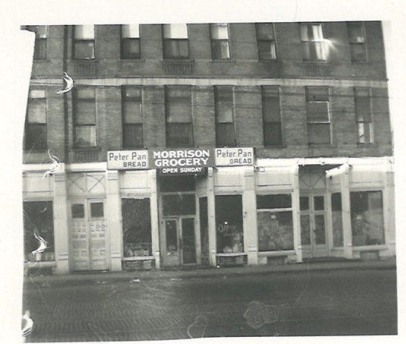
A business called Consolidated Merchantile and Supply Company was at 2702 Cuming in the 1930s and 1940s. The Zig Zag Sewing Company was in the same address in 1952, and the Morrison Grocery was there in the 1940s and 1950s. James Morrison lived at 2704 Cuming during that era, and was a model railroad guy, and Raymond Killingforth lived there in 1950 when he was married to Beverly J. Fairgrave. Loper’s Grocery moved in before 1955 and stayed there until 1965. Through the 1960s and maybe earlier, the Omaha World-Herald kept a station at 2706 Cuming. The Loper Vacuum Repair Company was next door at 2702 Cuming Street in 1967, and the Sincere Sewing Service was at 2702 Cuming in the 1950s and 1960s.
Apartments were still being advertised for rent in the building in early 1966. However, in October 1966, the Omaha Star newspaper announced the placement of the North Freeway at 27th and Cuming, and after date, none of the addresses here appeared in the newspaper or other print materials again. I assume it was demolished that year to make way for that new highway.
Many Other Demolished Places

In 1880, the City of Omaha set aside the block on 21st Street between Cuming and Burt Streets as a grain, hay and produce market they called the Cuming Street Market. It was still in effect in 1905, but I can’t locate any photos. Eventually, that market was closed and the block filled in. In 2015, as many of their neighbors experienced, the five buildings along Cuming Street between Florence Boulevard and 21st Streets were demolished by Creighton University. Mostly housing industrial businesses in recent times, the buildings once had a variety of used, including boutique stores and more. Modern Equipment Company once owned several of the buildings, and once owned many buildings and parcels of land along Cuming Street. In the past decade, Creighton University has mercilessly cut down dozens of historic properties in their quest to rebuild the Near North Side in their vision, devoid of any respect for the historic cultural heritage of the area. This destruction shows they’re still at it.

Founded in 1900, the Sam Riekes Equipment business moved to 2910 Cuming Street in 1959. By combining five separate storefronts and an adjacent warehouse at the corner, enough space was created for all the divisions. The business continues today, although at a different location.
Dozens of buildings have been wrecked along Cuming Street in the past 20 years, and many new structures are being built. Only time will show whether the past will be recognized by Creighton University, the City of Omaha or the countless new businesses and apartment buildings being constructed today.
The Future of Cuming Street

Under certain pressure from Creighton University, a decade ago the City of Omaha has set underway a plan to redevelop the entire Cuming Street corridor from its farthest eastern reaches past North 30th Street. Today, that vision is firmly implanted in the minds of city leaders, including the elected officials, government workers, financial investors and community boosters that move Omaha along.
The Cuming Street Sports and Entertainment District is packed with both of those specialties, and is only welcoming more development. With the elimination of the UPRR and building of the CenturyLink Center, nobody was wholly surprised when the TD AmeriPark was built along Cuming. The City calls this development the future of North Omaha, showing their hand. This is a baldfaced effort to jumpstart the gentrification of the Near North Side neighborhood, for better or worse, with or without the active engagement of residents in the area. In the most paternalistic and historically typical way, the City knows best.
You Might Like…
- Short History of the Near North Side
- Short History of Walnut Hill
- Short History of the Walnut Hill Reservoir
- Nebraska Biography of Thomas B. Cuming by guest writer Ryan Roenfeld
- History of Tip Top Products Company
- Short History of Omaha Technical High School
MY ARTICLES ABOUT THE HISTORY OF STREETS IN NORTH OMAHA
STREETS: 16th Street | 24th Street | Cuming Street | Military Avenue | Saddle Creek Road | Florence Main Street
BOULEVARDS: Florence Boulevard | Fontenelle Boulevard
INTERSECTIONS: 42nd and Redman | 40th and Ames | 40th and Hamilton | 30th and Ames | 24th and Fort | 30th and Fort | 24th and Ames | 24th and Lake | 16th and Locust | 20th and Lake | 45th and Military | 24th and Pratt
STREETCARS: Streetcars | Streetcars in Benson | 26th and Lake Streetcar Barn | 19th and Nicholas Streetcar Barn | Omaha Horse Railway
BRIDGES: Locust Street Viaduct | Nicholas Street Viaduct | Mormon Bridge | Ames Avenue Bridge | Miller Park Bridges
OTHER: North Freeway | Sorenson Parkway | J.J. Pershing Drive | River Drive
MY ARTICLES RELATED TO 45th and MILITARY
Military Road | Military Theater | Clifton Hill | Orchard Hill Neighborhood | Walnut Hill | Fontenelle Boulevard | Nebraska School for the Deaf | Saddle Creek Road | Cuming Street
Elsewhere Online
- “16/Cuming Sports and Entertainment District” by the City of Omaha
- “3837 Cuming Street – A Brief History” by Micah Evans for Adventures in Omaha History
BONUS PICS!


Leave a comment