North Omaha sits on the shoulder of a city that keeps growing, but leaves this community alone. Routinely forgotten about, the community is largely neglected by investors and developers who see it as dead space. Perched uncomfortably on the precipice of downtown Omaha, the rest of this growing metro looks at North Omaha’s foibles and history mercilessly.
Instead, Omaha is slowly devouring the southern boundaries of North Omaha in an apparent effort to gentrify the neighborhood for the benefit of Creighton University and the growing NoDo area. Respect for rich historic roots of North Omaha is almost completely missing.
All of this is being done in spite of history, the depth of which touch the very founding of the city, and even before that.
With this article I want to shine light on the neighborhoods of North Omaha. Instead of being off-limits or backwards, these blocks are diamonds in the rough, places looking for the reformation of community, the commitment of investors, and the possibilities of the future.
These neighborhoods have powerful histories that are tied up with stories that entwined with enigmas that are wrapped with anomalies, all of which are waiting for Omaha to discover, embrace, and uphold in the face of ignorance, racism, and the alienation that has faced the area for more than 50 years.
This isn’t meant to cover every single neighborhood in North Omaha, since I estimate there are more than 50. Instead, these are the ones I have most interest in right now. If you think I should include another neighborhood or if I have information wrong here, just right a comment and I’ll make the correction.
1. Near North Side

- Established: 1860s
- Location: North 24th on the west, Cuming on the south, North 14th on the east, and Locust Street on the North
- Article: History of the Near North Side
This is the historic heart of Omaha’s African American community. Before that, it was the heart of Omaha’s Jewish community. Settled by English, German, Swedish, Canadian and Irish immigrants, today its homes are treasured, its commercial areas are growing, and its civic infrastructure is getting revitalized by the City of Omaha. Many smaller neighborhoods are inside this community. The neighborhood features shotgun houses, Victorian style homes, American Foursquare, and eclectic styled houses. There are also several Commercial Vernacular buildings, Neo-Classical churches and an apartment building, a Prairie style and apartment complex, and other dynamic architecture styles throughout the neighborhood.
2. Long School
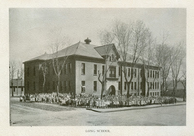
- Established: 1875
- Location: Hamilton in the south and Erskine on the north; North 24th on the east and the North Freeway on the west.
- Article: History of Long School neighborhood
The Long School neighborhood was an early economically diverse neighborhood in Omaha. Straddling the Near North Side and 24th and Lake Historic District, for more than a century, Long School had vibrant businesses, churches and synagogues, entertainment and other institutions, as well as the school itself. More than 50% of the housing stock has been demolished in the last 50 years, and almost all of the neighborhood’s historic assets are threatened by either demolition or redevelopment.
3. North 24th and Lake Historic District

- Established: 1870s
- Location: North Freeway on the west to Florence Boulevard on the east; Pinkney on the north to Cuming on the south
- Article: History of 24th and Lake
Built by northern European immigrants in its first two decades, Jewish immigrants started businesses and owned the area starting in the 1910s. African American businesses, churches and social halls took over this particular intersection during that same decade, and remain the heart of what’s happening in the community today.
4. Kountze Place

- Established: 1883
- Location: Sprague Street on the north to Pinkney on the south; North Fwy on the west to N. 16th on the east
- Article:History of Kountze Place
Created by Herman Kountze as an upscale streetcar suburb to make money, the Kountze Place neighborhood was home to the 1898 Trans-Mississippi Exposition and the 1898 Greater America Exposition. Its also home to many fine churches, former schools and beautiful homes built between 1890 and 1920. Several homes in this neighborhood are on the National Register of Historic Places.
5. The Town of Saratoga

- Founded: 1854
- Location: Storz Parkway on the north; North Freeway on the west; N. 14th on the east and Sprague Street on the south
- Article: History of Saratoga
A quiet neighborhood today, Saratoga was a hustling and bustling mini-burg early in its life. Built to rival Omaha City and established the same year, Saratoga once had its own dock town on the Missouri River called Sulphur Springs. Today, Saratoga’s historic landmarks have been largely obliterated, with no sign of Sulphur Springs still in existence. However, the past lays just under the dirt roads and powder brick buildings dotted throughout its landscape.
6. Sherman
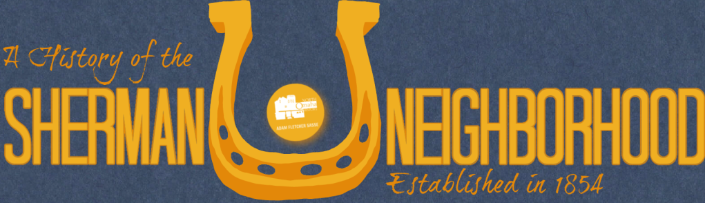
- Established: 1880s
- Location: Abbott Drive on the east and north; Locust on the south; Florence Boulevard on the west
- Article: History of Sherman
Starting in the 1860s farmers developed the lowlands below the North Omaha cliffs. In the 1880s, a school was established along Sherman Avenue, which extended to the community along present-day N. 16th. Eventually, a community was built in, churches were established, and the school grew. When the nearby Birchwood and Pershing Schools folded in the 1950s, their student populations were absorbed into Sherman, causing it to become a junior high school for a short while. Today, the neighborhood is surrounded by industry, Carter Lake Park, and the Eppley Airport.
7. Little Stokholm

Established: 1870s
Location: North 21st to North 18th Streets, from Cass north to Cumming Streets
Article: A History of Scandinavians In North Omaha
Arriving in large numbers to work on the railroads in Omaha starting in the 1870s, Scandinavians built churches, ran businesses, kept homes and congregated in this small area for more than 30 years. Eventually spreading throughout the city, today there are no signs left of this once-bustling area.
8. Miller Park Neighborhood

- Established: 1880s
- Location: Fort Omaha Historic District on the west, Miller Park on the north, Florence Boulevard on the east and Arthur Storz Expressway on the south
- Article: History of Miller Park neighborhood
- Article: History of the Miller Park Duplex Historic District
With initial homes built in the 1880s, George Miller’s land holdings in North Omaha were never formally laid out by him. After unsuccessfully bidding to be the home of the Trans-Mississippi Expo of 1898, Miller’s area started filling in. A school soon built and named in his honor, Miller passed away in 1920. The community continued to build, filling in completely just after World War II.
9. Minne Lusa Historic District

- Established: 1916
- Location: Vane Street on the north and Miller Park on the south; J. J. Pershing Drive and Florence Boulevard on the east and North 30th Street on the west
- Article: History of Minne Lusa
Designed and built by a single developer, this entire neighborhood became a historic district in 2015. Their excitement extends from 400 beautiful homes of a variety of styles, including Arts and Crafts, Spanish Colonial Revival, Craftsman, and American Foursquare, among others. A historic school, social club, commercial district and other elements make this a poignant, marvelous jewel in North Omaha’s spectacular historical crown.
10. The Town of Florence

- Founded: 1854
- Location: Mormon Bridget Road on the west to the Missouri River on the east; I-680 on the north to Craig Street on the south
- Article: History of Florence
Florence is the oldest neighborhood in Omaha, and one of the oldest cities in Nebraska. After the area was established as the Mormon’s Winter Quarters for their western excursion in 1846, it was re-established as a town by James Mitchell in 1854. In its early years, the town struggled to take the title of capital away from Omaha City, and even played host to an illegal Legislature held there one today. Today, it looks forward to a renaissance of business, social life and families. There are many historic buildings there, as well as other significant sites and stories to tell.
11. Florence Field

- Established: 1919
- Location: North 24th to North 36th Streets, from Redick Avenue to Weber Street
- Article: A History of Florence Field
The second large neighborhood started by ambitious North Omaha real estate developer Charles Martin, Florence Field didn’t finish infilling until 30 years after it started. Homes and businesses throughout the neighborhood reflect the sunny optimism of the times though, with steadfast standards mixed in with whimsical traits in the houses, streets and businesses. A mature neighborhood, there is a lot of fun in the area.
12. Belvedere Neighborhood

- Established: 1881
- Location: Redick Avenue on the north; Fontenelle Boulevard on the west; Fort Omaha on the south and N. 30th Street on the east
- Article:History of Belvedere Point
Originally platted as a pleasant suburb far from the city, Belvedere took more than twenty years to build up. During the time, the City of Omaha was able to condemn land to lay out the neighborhood’s defining boulevard. The neighborhood is also the site of one of North Omaha’s most notable landmarks, Belvedere Point.
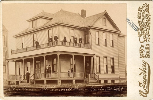
13. Monmouth Park

- Established: 1886
- Location: North 33rd to North 36th, Ames Avenue to C&NW
- Article: A History of Monmouth Park
Formally established in 1886, the Monmouth Park neighborhood was built around the Immanuel Deaconess Institute. A school, several churches and other institutions came and went over the years, but the residential fabric of the neighborhood has remained intact.
14. Collier Place
- Established: 1882
- Location: Ames to Grand Avenue; North 30th to North 33rd Street
- Article: History of Collier Place
Carved from a land grab called Scriptown upon the founding of Omaha City, the Collier Place neighborhood was a successful residential and commercial hub in North Omaha. Today its changed, but still alive.
15. Prospect Place
- Established: 1890s
- Location: Lake Street on the north and Hamilton on the south; North Freeway on the east and 36th on the west
Built around the illustrious pioneer-era Prospect Hill Cemetery, this once- thriving community was home to all the services and amenities of the early 20th century. In the 1950s, the federal government and the City of Omaha built massive housing projects at N. 30th and Lake called Hilltop. Demolished in the 1990s, today the community is being redeveloped.
16. Gifford Park Neighborhood
- Established: 1912
- Location: North Freeway on the east, N. 38th Street on the west, Dodge Street on the south and Cuming Street on the north
Dr. Harold Gifford, Sr. donated the land for Gifford Park at 35th and Davenport Streets in 1912 for a neighborhood park. The N. 33rd and California intersection became an important commercial center shortly afterwards, maintaining that status through the 1970s. Today the neighborhood is home to several beautiful historic homes, and fine institutions including the Duchesne Academy.
17. Bemis Park Neighborhood

- Established: 1889
- Location: Cuming Street on the south to Hawthorne Avenue on the north; Glenwood Avenue on the west to N. 33rd Street on the east
- Article: History of Bemis Park Landmark Heritage District
Bemis Park was platted by a wealthy Omahan who wanted to make a rich neighborhood for his clients to build mansions in. Designed to match the Walnut Hill’s exclusivity to the south, Bemis Park features a lollygagging boulevard, an easy park that once had a beautiful lagoon, and extravagant homes on large lots. In 1913, much of the neighborhood was obliterated by a massive tornado.
22. Benson
- Founded: 1887
- Location: N. 72nd on the west to Fontenelle Boulevard on the east; Ames on the north and and Western on the south
Erastus A. Benson was a banker and land speculator who laid out the Benson Place suburb of Omaha in 1887. Running a streetcar all the way to his town northwest of Omaha, he attracted residents with good land values and exclusive properties.
23. Walnut Hill

- Established: 1885
- Location: Cuming Street on the south, Northwest Radial Highway and Saddle Creek Road on the west, N. 40th Street on the east, and Lake Street on the north.
- Article: History of Walnut Hill
Built as one of North Omaha’s first streetcar suburb, Walnut Hill was established by Dr. Samuel Mercer. Mercer was an early real estate mogul in Omaha, soaking up land all around the city, building a major business block downtown, and establishing this neighborhood and its neighbor, Bemis Park. In addition to streetcar service, he secured street paving, two parks, and sidewalks and streetlamps for his entire neighborhood.
18. Gold Coast Historic District

- Established: 1890
- Location: 36th Street on the east and 40th on the west, Jones on the south and Cuming Street on the north
- Article: History of Gold Coast
Home to the Joslyn Castle, 39th Street quickly became a swanky address for Omaha’s wealthy to build their fine homes around the turn of the century. As the city’s second Gold Coast, these addresses were well-positioned for the business leaders, philanthropic heads and community figures who populated the fine homes in the district. The houses offer eclectic styles that have been continuously well-maintained since they were originally constructed.
21. Benson Downtown Historic District
- Established: 1887
- Location: Maple Street from the Northwest Radial Highway to N. 62nd Street
This community was established as the downtown for Benson Place, with streetcar service and offering all downtown amenities. Today it is being rehabilitated and its relevance has soared back.
19. Country Club Historic District
- Established: 1925
- Location: N. 50th Street on the east to N. 56th on the west; from Corby Street on the north to Seward Street on the south.
Designed to serve Omaha’s growing upper middle class in the early 1900s, the Country Club Historic District was literally platted on top of the former Omaha Country Club. Today, the area is renowned for its sheer numbers of well-designed, high quality homes.
27. The Town of Briggs
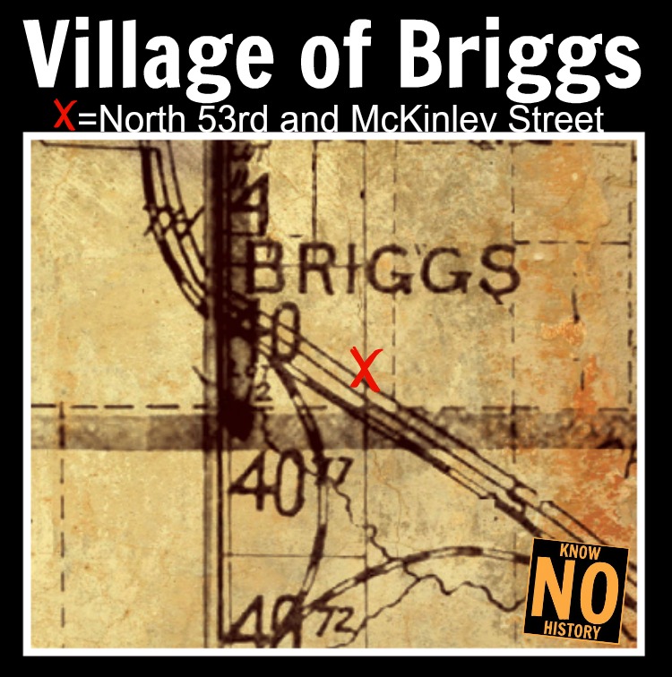
- Established: 1885
- Location: Garvin Street on the south to Highway 36 / McKinley Street to the north; North 53rd on the east and North 64th on the west
Founded in 1885, Briggs added a post office in 1892 that was open until 1913. The Chicago and Northwestern Railroad went through it, and there was a school there as well. It may have been known as Mannering as early as 1870. It was a small flag station northwest of Florence, and did not appear on the regular time tables by the railroad company. There were only an occasional train stops there for passengers, and freight was shipped regularly.
* Squatter’s Row

- Established: 1870
- Location: N. 11th on the east to N. 13th on the west; Nicholas on the south to Locust on the north
- North Omaha History article about Squatter’s Row
A lowland swamp that served as a city dump, squatters used tin cans, automobile fenders and all kinds of trash to build up the land. Claiming the higher ground since the 1860s, Cornelia “Granny” Weatherford was “one of the first.” Their homes were “constructed of tar-paper, tin cans and other material salvaged from the dump; many of the squatters earn their living by sorting the discarded junk and selling the salable articles.” In 1897, the Nebraska laws favoring squatters were changed and Squatter’s Row began emptying out. However, Granny Weatherford stayed until she died in the late 1930s.
* Little Russia
- Established: 1900
- Location: Indiana Street on the south to Franklin Street on the north; N. 25th on the east to N. 30th on the west.
Russian Jewish immigrants started flooding into North Omaha around the turn of the century. Escaping persecution at home, they came to Omaha for many reasons, including its well-established Jewish community. In Little Russia, there were apartments, businesses and a synagogue for this community. Local schools also offered Americanization classes for the immigrants, too.
26. The Town of DeBolt

- Established: 1890
- Location: Whitmore on the south to Craig on the north; North 57th on the east to North 64th on the west
- Article: A History of the Town of DeBolt
Located northwest of Omaha on the Chicago & Northwestern Railroad, the town of DeBolt was home to a school, a church and a post office from 1892 to 1899. Also called “De Bolt Place”, it had a stockyard that shipped regularly and several houses, but no businesses. Springville School was the original school serving this town.
* Bungalow City

- Established: 1904
- Location: Northeast shore of Carter Lake, near the intersection of Carter Lake Drive and Abbott Drive
- Article: History of Bungalow City
Lasting for less than a decade in the early 1900s, this neighborhood had more than 50 homes, docks with dozens of boats, and other features. It was moved across the lake to Iowa when Levi Carter Park was developed by the City of Omaha.
24. Central Park

- Established: 1870s
- Location: North 33rd to North 48th Streets, from Ames Avenue to Sorenson Parkway
- Article: History of Central Park
Established as a convenient farming town called West Saratoga, this neighborhood was part of the original 1854 plat for the Town of Saratoga. By the time that town floundered, West Saratoga had a grocery, church and school of its own. By the 1880s, the area was called Cherry Hill, and by 1900, lots were being sold there and it was called Central Park. There are several neighborhood landmarks today.
20. Orchard Hill

- Established: 1886
- Location: Hamilton to Blondo Street; North 36th to North 40th Street
- Article: History of Orchard Hill
Located along the original Military Road, aka Hamilton Street, the Orchard Hill neighborhood was carved from an old farm. Bordered by the Belt Line Railway at its peak, a lot of middle income managers, shop bosses and other working class and white color people built their homes here. The neighborhood is dissected by the John A. Creighton Boulevard, and bordered by other historical neighborhoods.
* Kellom Heights

- Established: 1865
- Location: Cuming to Hamilton Street; North 24th to North 30th Streets
- Article: History of Kellom Heights
Originally platted by Omaha a founding father of Omaha, this neighborhood had Russian immigrants and Black migrants, low-income and wealthy people. Whether concentrated on the successful commercial strip along Cuming or North 24th, or thinking about the Thomas Mansion on top of the hill at North 27th Avenue, the entire neighborhood was packed with history! Today, most of it is gone.
28. North Downtown Omaha

- Established: 1854
- Location: Cass to Cuming Street; North 9th to North 17th Street
- Article: A History of North Downtown Omaha
Established as part of Omaha when the city was founded, North Downtown developed slowly but steadily for the following 25 years. But when it boomed, it went big AND small! Today, there’s a re-invention of this that could tip the balance for years to come…
14. Druid Hill

- Established: 1886
- Location: North 30th to North 36th, Pratt to Sprague Street
In the 1880s, the city of Omaha paved a boulevard from Hamilton along the far west side of the hills, and then west from North 33rd to Fontenelle Boulevard. Highly desirable property, the section from Pratt to Sprague, from North 30th to North 36th Street was developed in the 1880s. With factories built along the Belt Line Railway and commercial properties along North 30th Street, the neighborhood also had its own school and social hall, as well as a lot of homes.
20. Plum Nelly

- Established: c.1881
- Location: Maple to Bedford Street; North 36th to North 39th Streets
- Article: History of Plum Nelly
Plum Nelly was a secret neighborhood that’s now a lost neighborhood in North Omaha. For several decades, African Americans lived in small homes, ramshackle houses and lean-tos throughout the woods in this area.
29. Omaha View

- Established: 1885
- Location: North 26th on the east to North 36th Street on the west; from Blondo on the south to Pinkney on the north
- Article: History of Omaha View
With more than two dozen homes more than 130-years-old, this neighborhood is an under-acknowledged jewel of built history in North Omaha. However, there are more than a few modern architectural quirks there, too!
31. Prettiest Mile in Omaha Historic District

- Established: 1890s
- Location: Florence Boulevard from Reed Street on the north to Sorenson Parkway on the south
- Article: History of Florence Boulevard
In the early 1890s, the City of Omaha hired nationally reputed landscape designer H.W.S. Cleveland to establish a unified plan for the city’s parks and boulevards. Then treated as an extension of parks, the boulevards were beautified and respected, left without streetcars and really revered for their central roles throughout the city. The northern section of Florence Boulevard was one of the most revered sections, and was called the “Omaha’s Prettiest Mile Boulevard” for more than a decade. With fine homes already established in the so-called Parkwood subdivision, in the 1910s this stretch in-filled and left a beautiful legacy still obvious today.
32. Fairfax

- Established: 1906
- Location: N. 36th to N. 42nd, Sprague to Pratt Streets
- Article: A History of the Fairfax Neighborhood
A suburb tucked away between streetcar lines and boulevards, Fairfax didn’t finish in-filling until after WWII. Today it’s packed with straight streets, small starter homes, and several churches. The neighborhood includes a few remarkable Art Deco homes.
33. Clifton Hill

Established: 1885
Location: North 40th on the east and North 45th / Military Avenue on the west, Blondo / Patrick Street on the south and Lake Street on the north
Article: A History of the Clifton Hill Neighborhood in North Omaha
Built as a suburban escape for downtown workers, the Clifton Hill neighborhood has more than two dozen houses over 125 years old. There is also a historic commercial district, a Nebraska Territory road, and a railroad vital to the city’s growth attached to the neighborhood.
34. The Town of East Omaha

- Founded: 1854
- Location: Eppley Airport on the north and the Missouri River on the South; Abbott Drive to the west and the Missouri River on the East
- North Omaha History article about the Original East Omaha
Originally built as a company town for the railroads and later the East Omaha Box Company, the town of East Omaha was originally annexed by the City of Omaha in 1856, and then re-annexed in 1957. With many of its 2,000-plus residents working in nearby factories and other blue collar labor, the town was served by a school and two grocery stores. When a flood decimated the area in the 1950s, Omaha absorbed it. Today, all residences from the area are gone, and only the box factory still remains from the olden days.
35. Malcolm X Memorial Neighborhood
- Established: 1880s
- Location: Maple on the south to Spaulding on the north; N. 30th on the east to N. 40th on the west
Home of the Malcolm X Memorial Birthsite, this neighborhood is a historic African American enclave in Omaha. Census data shows that Blacks from the South moved to Omaha in earnest starting in the 1880s. Looking for affordable, safe areas where their liberties and safety wouldn’t be threatened, many families lived in this far-removed area. Several of the oldest homesites around N. 37th and Bedford date from this era, with a few newspaper reports identifying this as a Black neighborhood. Today, its the center of a renaissance movement to build and support Omaha’s African American community.
36. Fort Omaha Historic District

- Established: 1879
- Location: Laurel Street on the north and Sorenson Parkway on the south; N. 30th on the east and N. 33rd on the west
- Article: A History of Fort Omaha
Built as a supply fort for the northwest territories of the United States, Fort Omaha’s roles expanded and contracted greatly throughout the years. It served as a supply depot; command center for the Indian Wars; balloon training school; signal corps headquarters for the US Army; a WWII prisoner of war camp; a US Naval and Marine Corps Personnel Center; and presently, as a campus for the Metro Community College. It was abandoned by the military at least three times during its existence, too.
37. Jefferson Square
- Established: 1856
- Location: From North 15th to North 18th, Chicago Street to Cuming Street
- Article: A History of the Jefferson Square Neighborhood
One of the first neighborhoods in Omaha outside of downtown, the Jefferson Square neighborhood was centered around the city’s first and longest-standing park. After shortly being packed with residential houses and small mansions, it became urbanized by the 1880s with tall buildings and tenement squares. Becoming associated with the city’s homeless population, it was mostly demolished in the 1960s for the interstate. Today the namesake park is long gone and only a few buildings still stand.
38. Bedford Place
- Established:
- Location:
- Article: A History of Bedford Place
39. Crown Point
- Established:
- Location: Sorenson Pkwy on the south to Redick Ave on the north; Fontenelle Blvd on the east to N. 42nd St on the west.
- Article:
40. Fontenelle View
- Established:
- Location:
- Article:
41. High Point
- Established:
- Location:
- Article: A History of High Point
42. Montclair
- Established:
- Location:
- Article:
43. Redman
- Established:
- Location:
- Article:
44. Ponca Hills
- Established:
- Location:
- Article: A History of Ponca Hills
45. Wakonda
- Established:
- Location:
- Article:
46. Wyman Heights
- Established:
- Location:
- Article: A History of Wyman Heights
47. Lakewood Gardens

- Established: 1927
- Location: North 9th Street on the west to North 2nd on the east; from Browne and Fort Streets on the south to Arthur C. Storz Expressway on the north.
- Article: A History of Lakewood Gardens
Located near the industrial edge of east Omaha, the Lakewood Gardens subdivision has historic roots going back almost a century. Once owned by the Creighton family, the lots there were truck gardens for generations and today the neighborhood, with gravel roads and few sidewalks, it maintains a rural feeling.
The Future
This is an introduction to the historical neighborhoods of North Omaha, which I include everything north of Dodge Street to the Washington County line and east of North 72nd Street to the Missouri River. Other historic neighborhoods in the community include Birchwood, Dundee, Fairview Acres, Middleville, and others.
The future of these neighborhoods is yet to be written, and everyone has a role in helping these dreams happen. Let me know what you think, what you’d add or take away in the comments below.
You Might Like…
- Architectural Styles in North Omaha
- Social Halls and Social Clubs in North Omaha
- Redlining in Omaha
- Historical Sightseeing in North Omaha
MY ARTICLES ABOUT HISTORIC NEIGHBORHOODS IN NORTH OMAHA
National Register of Historic Places Historic Districts in North Omaha: 24th and Lake Historic District | Benson Downtown Historic District | Country Club Historic District | Dundee/Happy Hollow Historic District | Fairacres Historic District | Fort Omaha Historic District | Minne Lusa Historic District | Nicholas Street Historic District
Historic Neighborhoods in North Omaha: Bedford Place | Belvedere Point | Bemis Park | Benson | Briggs | Bungalow City | Carter Lake, Iowa | Central Park | Clifton Hill | Collier Place | Creighton University | Crown Point | DeBolt | Druid Hill | East Omaha | Fairfax | Florence | Florence Field | Fort Omaha | Fontenelle View | Gifford Park | Gold Coast (Cathedral) | High Point | Jefferson Square | Kellom Heights | Kountze Place | Lakewood Gardens | Little Russia | Long School | Malcolm X Memorial | Miller Park | Miller Park Duplex Historic District | Monmouth Park | Montclair | Near North Side | North Downtown Omaha | Omaha View | Orchard Hill | Plum Nelly | Prettiest Mile in Omaha | Prospect Place | Raven Oaks | Redman | Saratoga | Sherman | Squatter’s Row | Sulphur Springs | Ponca Hills | Wakonda | Walnut Hill | Winspear Triangle | Wyman Heights
Lost Towns in North Omaha: Benson | Briggs | DeBolt | East Omaha | Florence | Saratoga | Sulphur Springs


Leave a comment