
Special thanks to Ronald Potter, Donald Gappa, Matt Lesley and Ryan Roenfeld and others for their contributions to this article!
The original town of East Omaha was south of the present-day Eppley Airport, east of Abbott Drive, and north and west of the Missouri River. Throughout the years, this town has been home to more than 2,600 homes, countless businesses, a school, the East Omaha River Rats, and now the Open Door Mission, the Omaha Correctional Center, the Omaha Immigration Court, and businesses like Monarch Oil and the FleetPride Service Center. This is a history of more than 160 years in East Omaha, Nebraska.
Note that this article doesn’t include lots of areas either presently referred to as East Omaha or historically called East Omaha. This article doesn’t squabble about the City of Carter Lake, Iowa, or make hay about Abbott Drive cutting through another state. Instead, it’s focused on a former town, its historic successes and failure, and the real people who lived there for generations before they were kicked out by the forces that be, including floods, officials and misfortune.
The First Thirty Years

Claimed by Edmond Jeffries in 1853, this area was known known as East Omaha from its earliest years. That was before the Nebraska Territory opened for claims, but Jeffries got a title when he could in 1854. He sold land, raised crops and had a home on 30 acres in East Omaha.
Before flooding created Carter Lake in 1877, the East Omaha community wrapped around the west bank of the Missouri River to the former town of Saratoga. Gigantic floods in 1877 and 1881 forced the river out of its banks and shortened the river’s course. Everyone who’d lived on the south side of the lake was now on the Nebraska side of the Missouri River, and East Omaha was more a part of Omaha than ever.
The first settlers lived in East Omaha as early as the 1850s, before the Nebraska Territory was opened for settlement claims. For the next forty years, the little town hobbled along slowly, with truck farms all around and grand schemes in the distance. East Omaha was part of the Saratoga Township during this era. From around 1857 to the 1890s, Saratoga extended from North 42nd Street east to the river. There were at least three pioneer school districts in the area, including the Birchwood School that was originally on the north side of Carter Lake to serve students from Bungalow City and East Omaha. East Omaha had a one-room wooden schoolhouse at 28th Avenue East and Avenue K.
There were big plans in the works almost the entire time.
East Omaha Land Company

The East Omaha Land Company was “a syndicate composed of the wealthiest railway magnates and real estate capitalists of Omaha.” Formed in February 1887, they were a group of speculators who wanted to make money by selling land. The owners of the company included W. J. Holcomb, Thomas L. Kimball, G. W. Holdrege, Henry W. Yates, R. C. Cushing, and Arthur Potter of Omaha. However, investors from the East Coast were involved too, including Fred L. Ames and C. E. Perkins, who represented a group of investors from Boston; John Lowen Welsh was an investor from Philadelphia. This group of investors was also deeply involved in the Union Pacific Railroad; the East Omaha Land Company was simply an extension of the UP.
Pooling their money together, the investors bought more than a 1,000 acres of what was called “the Island,” a plot of land greatly affected by the 1877 flooding that created Carter Lake.
Arthur Potter had a vital role in East Omaha by working as the general manager of the East Omaha Land Company and its holdings for a decade. Arriving in Omaha in 1884, he immediately started his own real estate company. When the land company opened, he directed the process of grading streets, building the electric streetcar and workers’ homes, and inviting the factories to move into the factory district. He singularly convinced his fellow investors that East Omaha could be to Omaha what South Omaha was; a magic city with massive, fast growth to make them rich.
The largest single real estate deal in Nebraska up to 1890 is said to have occurred there. That year an unknown property in East Omaha was sold to the Omaha Bridge and Terminal Railway Company, or OB&TR, for nearly $700,000. The company’s lands extended between the westside of present-day Carter Lake to the Missouri River and from the south side of Carter Lake to the North Omaha Bottoms. The East Omaha Land Company partnered with the Burlington Railroad to establish the OB&TR in order to develop industrial areas in Omaha and Council Bluffs.
These people immediately committed money to improving the land with streets, railroads, houses, and factories. They wanted East Omaha to become a regular town, sell lots to businesses and factories, and create a vibrant suburb north of Omaha City. In July 1890, the company reportedly spent a total of $300,000 clearing low-lying land of willows and to grade streets before lots were offered for sale. They moved in hundreds of tons of clay from the newly-constructed Florence Water Works on the Omaha Road tracks to shore up road beds throughout the community. In 1890, they also paved two miles of Locust Street right away using cut granite stones.

In the early 1890s, there were 500 acres of grain growing north of Locust Street, and several lots cleared for industrial development. That year, the Carter White Lead Company had started building their plant, and the Omaha Box Company and others were moved in. The land company developers were proud of Locust Street in particular, since it was 100′ wide for most of the 2 1/4 mile stretch from Sherman Avenue (now called North 16th) to the Missouri River and paved with granite blocks. Along Avenue J, there were large cottonwoods left standing for shade over large lots cleared for housing. A newspaper report from 1890 said, “In the midst of the residence portion ten acres are reserved for a park.”
The first group of houses built in East Omaha was constructed in 1890 by the East Omaha Land Company. Intended for workers at the factories, there were originally 24 small homes with city water, sidewalks and fences. In two more years, there were a dozen more along with pop-up homes and other places for people to live. As early as 1891, there was an electric streetcar running from the intersection of North 16th and Locust Streets to these houses and the factory district. There were settlers there before, but without official title to their land, or as farmers, or one of the few island owners in the Missouri River bend by East Omaha. By the 1950s, there were 2,600 residents living in hundreds of homes in the town.
Within a few years, more than 2,000 acres west of the Missouri River and east of the bluffs below Florence Boulevard were covered by 72 miles of roads made by the company. They used granite slabs to pave Locust Street and North 11th Street, which originally extended into North Downtown Omaha. However, all the paved roads in the world didn’t help the industries that were meant to move into the area.
Building a Big Bridge

When you manufacture things, you need to ship them, and in the 1890s when you shipped things, you wanted to use the railroad. The East Omaha Land Company knew this, and they wanted to get a railroad line into their town.

In order to get a railroad into East Omaha, there had to be a major bridge to cover the span of the Missouri River. The downtown Omaha railroad bridge received all the traffic for the city, and that was keeping East Omaha from being successful. One of the grand schemes for the community was to build the necessary bridge.
It was originally opened by the OB&TR in 1891. After being built as a multi-use span to carry pedestrians, electric streetcars and trains, it has sat unused for decades. The bridge is a 521′ long double swing truss bridge that still connects Council Bluffs with East Omaha. In 1903, the Illinois Central Railroad, or IC, acquired the bridge through a subsidiary company. Rebuilt after major flooding in 1901, the second version of the bridge was opened in 1908. The IC contracted with the American Bridge Company to convert the Iowa side to a second swing bridge built of steel.
Today, the East Omaha Bridge, also known as the IC Bridge or the East Omaha Bridge, is owned by the Canadian National Railroad.
All bridge traffic ended in 1980, and the bridge has sat empty and falling apart since then.
East Omaha Factory District

Luring industries to the area with the East Omaha Bridge was a success. Between the late 1880s and the 1930s, there were a number of large plants built in East Omaha. Attracted by the Illinois Central Railroad and free land from the East Omaha Land Company, these plants were referred to as the East Omaha Factory District by the Evening World Herald.
Throughout the years, some of the businesses located in the factory district included the Barber Asphalt Paving Company, and the Adamant Wall Plaster Company. The Omaha Cereal Company plant was there too, along with the Monitor Hard Plaster Works.
By 1890, the East Omaha Box Company was built there, too, and maintained its factory there through 2018. In 1891 the Marks’ Brothers Saddlery Company built a large plant in the East Omaha Factory District. Manfucturing saddles and harnesses, they employed 75 people in their three-story brick building. In 1893, the Martin and Morrisey factory was located there. The American Cereal Company, originally called the Pearl Hominy Company, had a factory there, too. In 1891, 15 workers in their East Omaha mills were making 200 barrels a day with pearl hominy and corn meal. They sold most of their product in the northwest and the South.
The J. T. Robinson Notion Company built a four-story plant in East Omaha in 1885, eventually buying the neighboring DeGraff Manufacturing Company, which had a four-story building in the East Omaha Factory District. 125 workers at this plant made overalls, work shirts, jumpers and pantaloons, and six traveling salesmen sold them across the country. Kilpatrick-Koch Dry Goods Company eventually bought them out.
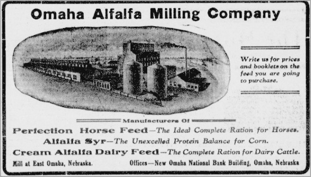
The Omaha Cereal Company opened in the late 1880s, burned down twice and closed permanently in 1916, similar to the Omaha Hay Company, which was located next to the box factory. Their factory was permanently closed after a massive fire in 1901. It didn’t close because of that single fire though–but because of the three others in the decade before that! The Omaha Alfalfa Milling Company suffered a similar fate. There were a lot of fires in the factory district.

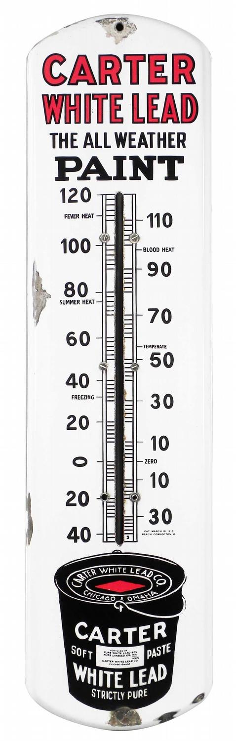
In 1886, Levi Carter opened the Carter White Lead Company south of downtown Omaha. A generous offer of land and tax breaks lured him away from the old site of the Omaha White Lead Company by the railroad depots, and he built large.
In 1885, prices bottomed out in the lead market and the company was forced to shut down the works. The next year, Carter bought it cheap and reopened the plant, speculating the market would come back. It did, and within five years he was stinking rich. The Carter White Lead Company was born. The plant was originally built on South 20th Street.
Levi Carter ended up selling paints and all kinds of treatments for homes to hardware stores and paint stores across the Northeastern United States. He bought a formula for white lead paint concocted by a Dutch entrepreneur in the 1880s. Within the next 40 years, Carter brand paints were sold across the entire nation. That brand stopped being used when the Dutch Boy brand was used exclusively.
On June 14, 1891, the Carter White Lead Company caught fire and burnt to the ground. It incinerated the entire plant, which had just been rebuilt to increase production. The only things saved were the warehouse and office, and several outbuildings. The plant itself was completely obliterated. Carter moved the plant to East Omaha and rebuilt on an even grander scale.

By the end of 1891, a new plant that cost $200,000 was built in East Omaha, and within two years the plant’s output reached 7000 tons. There were 21 buildings at the new plant, which was located at North 21st Street East and North 22nd Street East, between East Locust Street and Avenue J. Carter’s company became the biggest white lead refiner in the nation, and owned factory in Omaha and another in Chicago. The Chicago plant was the largest single white lead factory in the world.
In 1900, Carter consolidated manufacturing with his new plant in suburban Chicago and closed his East Omaha plant. Levi Carter died in 1903. Two years later, Edward J. Cornish was elected president of the board and appointed president of the company. He reopened the plant, and sold the company in 1907 to National Lead, the white lead trust. They closed the plant in 1916, and continued making the Dutch Boy paints and paints under the Carter name, too.
The Carter White Lead Company dissolved in 1936. All of its property was distributed to the National Lead Company, which was headquartered in New Jersey. The new owner continued to operate the Chicago plant as the Carter Brand of the National Lead Company.

While that was nearly the end of the East Omaha Factory District, it wasn’t the end of industries in East Omaha. Another was rising while these closed, and it sure was greasy!
Oil Industry

East Omaha was an oil town, too. A number of locals worked for Mona Oil over the years, but didn’t know its history. The Monarch Manufacturing Company was started in Council Bluffs in 1889. Shortening their name to Mona Motor Oil in the 1910s, Mona had major refining and distribution operations in East Omaha. Renaming the business with the owner’s name in the 1920s, the new Searle Petroleum Company launched a new advertising stunt in 1925 called a radio station.

KOIL, whose call letters were inspired by Searle’s advertising, was the second radio station in the Omaha metro area. It was the first ABC affiliate west of the Mississippi River, and the second NBC affiliate west of the Mississippi River. The station continues today. Between 1910 and the 1960s, the company suffered more than a half-dozen major fires at its East Omaha refinery, including an explosion in 1952 that killed two men. The company did not last though, and was bought out in 1964. There were several buildings in East Omaha associated with Searle and Mona, including the warehouse pictured above.
Railroad Industry

Railroads were one of the big industries in East Omaha.
By the turn of the 20th century East Omaha had a mess of railroads shooting through it, past it and around it. They included the Illinois Central, the Omaha Bridge and Terminal Railway Company, the Chicago, St. Paul, Minneapolis and Omaha Railway, aka the Omaha Road, and the Union Pacific. There was a terminal in East Omaha for the Omaha Bridge and Terminal Railway Company, and along with nearby roundhouses, a major switching yard, and the bridge, East Omaha was majorly impacted by the railroad industry.
Other Money Making
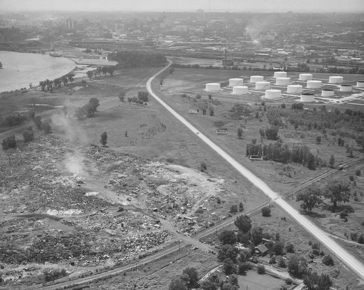
Historically, there were other industries in East Omaha too. The largest was auto-wrecking, which had been happening in the area since the 1920s. There were salvage yards and an illegal dump, too. Starting in the 1960s, airport-related companies popped up along Abbott Drive. They were originally car rental companies and commercial parking lots; today, there are hotels too.
A Possible Home for the Big Show

East Omaha, east of Carter Lake, was the preferred site for the Trans-Mississippi and International Exposition of 1898. The area considered was between Carter Lake on the south and Florence Lake on the north, which is now where Beechwood Trailer Courts are now located. Florence Lake Hotel was once on this site.
A period newspaper account reported that,
It has about 1,000 acres available… offers level ground… is dotted with trees… plentiful water supply. It is less than 3 miles form the Downtown Post Office. A paved street (16th) already extends almost to the site and a new bridge across the Missouri River makes accessible from Iowa.
The property lost out, and the 1898 Trans-Mississippi and International Exposition was held up Locust Street at North 16th Street.
The US Supreme Court Weighs In
Iowa and Nebraska didn’t always get along.
After floods in 1877 and 1881, the states argued over and over about who owned which land that switched sides along the Missouri River. After losing in their district court, Iowa took Nebraska to the US Supreme Court.
In 1892, the Supreme Court held that the sudden change in the river’s course did not change the original boundary. In Nebraska v. Iowa,they ruled that a large area of land formerly known as East Omaha was still part of Iowa. The Court let Nebraska and Iowa come up with their own plan to straighten things out, and they did. Today, more than a century later, all roads into Carter Lake run through East Omaha and North Omaha.
Growing a Town

In 1903, the East Omaha Land Company was still selling land, with most of their holdings east of the lake. With their road network and streetcar service, that year they advertised East Omaha as “the manufacturing center of Omaha.”
The town of East Omaha went on. In 1950, there were 2,500 residents. There was a constable who served as the local law enforcement for many years, with support from the Omaha Police Department. Five grocery stores, six taverns and the school were among the bedrocks of the community. Harold’s, which went on to become a citywide grocery chain, was founded in East Omaha. There were several other businesses, too, including a machine shop and garages.
Neighborhood Development

Platted in 1890, the East Omaha residential area was originally laid out to have hundreds of houses and was seen as a boon to the area. Workers for the Carter White Lead Company were treated to cottage homes along country homes, with trees lining the river and spread throughout the area, and neighborhood development was seen with high potential.
The Roots of Levi Carter Park

After Levi Carter died, his widow Selena Carter Cornish remarried Edward J. Cornish. Cornish, who was the chairman of the Omaha Parks Board, convinced her to donate some of Carter’s land to the city to commemorate him, along with $1,000,000 for improvements. In 1907, she did that and a beautiful boardwalk was built around the lake, along with a boathouse and other amenities. It is called Levi Carter Park, including the Omaha Municipal Beach and the former site of Bungalow City, as well as the original site of Eppley Airfield.
Flying Into the Future
![New Municipal Airport [Eppley Airfield], Omaha, Nebraska](https://northomahahistory.files.wordpress.com/2016/12/eppley-2.jpg?w=640)
Eppley Airfield was opened as a part of a land grab by the City of Omaha in the early 1920s. Seeking to grow their by-then-successful Levi Carter Park, the City purchased 200 acres east of the park. However, within a year of the purchase flyers of new-fangled airplanes were landing their crafts there. By 1926, the City was ready to open Municipal Airport on the grounds, soon after called the American Legion Airfield. It was renamed for generous donor Eugene Eppley in the 1950s.
The airport didn’t go so well for East Omaha though. When it was started in the 1920s, there was a concern among East Omaha’s residents that it took away potentially taxable land from potential town residents. This issue rose up repeatedly into the 1950s when the District 61 school superintendent cited the issue because of school financing issues.
Then, under the guise of growing the facilities, eventually all of the homes in the area were bought and demolished to grow Eppley Airfield. Today, there is no homage from the airport to the community, no recognition for the heritage lost, and little love from past residents towards the ever-hungry facility.
Growing a Town

In the 1920s, East Omaha got two institutions that held the community together: East Side Presbyterian Church and the Pershing School. Two writers, Martha Stein Volovich and Marie Stein Alford, researched and wrote a very thorough history of both these places that I’m going to borrow from. During that same decade, Locust Street was recovered with gravel, gritty nightclubs opened in East Omaha, and the community faced more challenges.
East Omaha Presbyterian Church

East Side Presbyterian Church was the heart work of M. Adela Doty. Starting in 1928, she worked with the local Presbytery and the Omaha Presbyterian Theological Seminary in North Omaha to build a worship hall for East Omaha. It was built at 2304 Avenue K. As the membership expanded, there were weddings, baptisms, birthdays and more that were constantly celebrated. Members came from the Sherman neighborhood and around Florence Lake, and stayed at the church for decades. However, the church wasn’t official until 1952, when East Side Presbyterian Church was formally founded. After that, the Doty Hall Educational Building was built across the street and dedicated in 1961, and a parsonage was built at 2408 Perkins Avenue. The last new member joined the church in 1985, and it was closed soon afterwards.
Pershing School
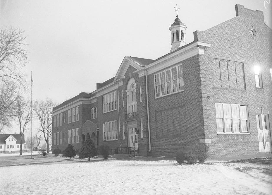
A one-room schoolhouse was organized in 1892 and was the only school in District 61. In 1926, the district paid for a $65,000 building to replace the wooden schoolhouse. The building was called the Pershing School, and was located at 28th Avenue East and Locust Street. Students chose the name for their new school in honor of General J.J. “Blackjack” Pershing, a hero of World War I who is also celebrated with a drive and monument in North Omaha.
Culture
East Omaha was an individual town with its own culture, habits, hobbies and ways of being. While East Side Presbyterian was a center of some peoples’ social lives, others had their fun in several bars, some in a few clubs, and a few picked through the town dump for good times.

Chez Paree was a nightclub originally located in East Omaha. With a front including popular entertainers, singers, comedians and others, the gambling casino in the back ran freely through the 1930s and 40s. On February 11, 1942 there was a fire that leveled the building. The next day, February 12, 1942, there was a brand-new Chez Paree in Carter Lake. They moved the operation into Iowa because Nebraska’s state patrol and Omaha’s police department were becoming intolerant of the operation.
Aside from Chez Paree, the Stork Club was also in the area. Bars in East Omaha included the Hi Lo and the Mainliner.
Flooding Disasters

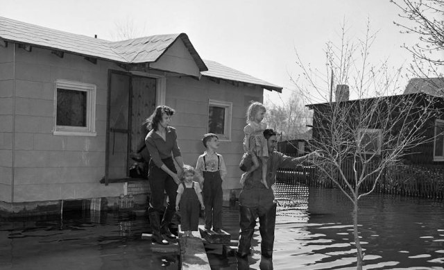
Floods constantly hounded East Omaha. Major events happened in 1877, 1890, 1901, 1919, and finally, in 1947 and 1953. They happened after that too in 1964, 1987, 1990, 1993, 2015 and 2019.
In 1947, a flood obliterated many of the homes in East Omaha. Around this time, Pershing School had 750 students in kindergarten through eighth grade, with another 108 students going to high schools in Omaha with their tuition paid by the county. There was an eight acre playground next to the school. A decade later, after many residents moved away and the student population dropped, District 61 was absorbed into the Omaha Public School District. In January 1948, the Pershing School became an Omaha school.
Building the Levees

In the 1920s, it was decided that East Omaha needed a levee system to protect homes and farms from Missouri River flooding. A report from the Omaha Chamber of Commerce said the East Omaha Drainage District had undertaken work to construct a levee along the south and west sides of the Missouri River. Extending from Beechwood to the Winspear Triangle and further, the levee would protect more than 7,000 acres from flooding. The report said,
“This immense body of land, with the beautiful lake formation, numerous recreation resorts, fine boulevards, great stretches of farm and garden lands, and numerous industries and railroad trackage, is worth millions of dollars to Omaha, and the foresight and enterprise of the men who have undertaken the permanent protection of this district will be appreciated in years to come.”
—Omaha Chamber of Commerce Journal, Volumes 9-10 (1920)
The leaders of the East Omaha Drainage and Protection District were A. L. Reed, president of the Byron Reed Company, which owned much of the land in East Omaha; A. N. Eaton, whose Nebraska and Iowa Steel Tank Company was located there; Fred S. Knapp, president of the Omaha Box Company; John P. Webster, and Peter Lesch, who owned a large farm northeast of the lake. Their self-given goal was to “permanently protect this large and important district from the encroachments of the river.”
Moving Into A Trust
After the great land speculation in the area during the 1890s didn’t pan out, in 1903 the leftover property was deeded to a new entity called the East Omaha Land Trust. In its first 40 years, the Trust wasn’t quiet. Instead, they were actively involved in the Omaha real estate scene through their agents at the Byron Reed Company. Managers often bought and sold land throughout downtown Omaha, East Omaha, North Omaha and South Omaha. They were speculators who wanted to make money, and while some were locals, many were on the East Coast and didn’t care about the outcomes of their investments beyond profit.
Farms, Gardens and Houses

In 1917, one of the more local investors inquired to the Byron Reed Company what should be done with the Trust’s holdings. Apparently he was tired of sitting on the land, which by then was made of 80% of the original land owned by the East Omaha Land Company. Giving up on industrial development that year, the Byron Reed Company began selling lots for residential and farm development “for sale to the man of moderate means.” 357 lots made of half-acres and acre lots were platted in the “Nakoma Development” in September 1917. They sold out in three days. Other additions were added, and more than 300 lots were sold by 1930. According to the newspaper, at the time of the first sale in 1917 there were 100 people living in East Omaha. By 1930, there were 1,100.
Ironically, one of the investments they made happened in 1927, when the Trust donated $500 dollars towards the construction of the American Legion Hangar at the Omaha Municipal Airport. Eventually, along with flooding and the City’s neglect, the airport eventually lead to the end of East Omaha.
In 1930, the newspaper reported the area was “Coming into its own: After years of problems, things look bright for the residents of East Omaha.” Excitement for the development of the new airport, the restoration of Carter Lake, the incorporation of the Town of Carter Lake, and the popularity of the nearby Carter Lake Club were all cited as causes.
The 1930s were a busy time for the Trust. During that decade, the US Secretary of the Navy, Charles Francis Adams; John S. Ames; and Charles E. Perkins controlled the Trust in the 1930s. They were all located in Boston, and local control of the Trust was apparently over. In 1934, the trio hired a law firm to push squatters off their lands. Apparently, there were a dozen squatters living along the original levees built in the 1920s who believed it was government land. The group lost, eviction notices were served, and they left. However, in keeping with squatting laws then, they moved back just 30 days later.
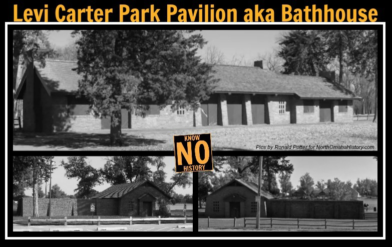
The Trust sued the City of Omaha in 1939 for more than $7,000 after the City crews tore out cobblestones on Avenue H East without permission. Those cobblestones were used by local Civilian Conservation Corps crews to build the now-historic Carter Lake Bathhouse Pavilions in 1936. In 1940, the City settled that suit by paving Avenue H with asphalt as a compromise with the Trust.
In the same decade, the US Army Corps of Engineers dredged the Missouri River for the first time and opened it to shipping after decades of silt blockage. Expecting a boon in riverfront land sales, the Trust looked forward to making money from their massive holdings from Beechwood to the Winspear Triangle. However, despite opening in 1936-37, values never shot up as high as they expected and sales faltered.
Managed for a longtime by important local mogul John Webster, in 1945 the Byron Reed Company gained control of the trust permanently.
The End of East Omaha

East Omaha was challenging to Omaha, and was treated as the “ugly step child” of the city for more than 50 years. This started in the early 1900s when the big taxes from land sales was gone, the railroads were installed, factories were built, and people were living there. Omaha simply didn’t want to deal with East Omaha.
The land was inconveniently located on the north side of Iowa’s property on the west side of the Missouri. That made sending police there challenging, and given the in-town way of dealing with problems, jurisdiction there felt strained at best. The Pershing School operated on its own through District 61, and there were no other public facilities there. Streets, streetlights, sewers, and sidewalks were installed by the land company, and the City of Omaha felt no obligation to keep them up.
Combined with the rural nature of the area between the river and the bluffs by Florence Boulevard, East Omaha felt disconnected and irrelevant to the City of Omaha. They left it out of city limits well into the 1950s.
That changed in July 1957, when more than 800 people petitioned the City of Omaha Planning Commission to annex East Omaha. The proposed area covered 306 acres and included 662 residential structures and estimated 2,800 people. There were also 24 retail establishments in the area, mostly on Locust Street, and lots of independent junk car dealers. At this point, there were 11.5 miles of streets with 1.5 miles of them covered in concrete. The Omaha Police Department, which patrolled the area, considered it a “high crime” neighborhood.
By 1970, Locust Street and 25th Street leading to the marina were the only improved streets in East Omaha. Out of 2,298 people who lived in the area, 94.9% were white, with 89 African Americans and 26 American Indians, and two marked as other. Only 24.5% of residents had finished eighth grade. Meanwhile, 9% of the homes had no plumbing, 29% had no connection to the public sewer, and 65% were owner occupied. It looked like the plan was for the City to buy the lots out, and they had a way.
In 1974, the City of Omaha Planning Board decided to vacate nine streets in East Omaha. Suggesting that the Omaha Airport Authority’s long-range plan was in motion, the board saw it was necessary to expand runways and terminals in “about a decade,” and they took action. The streets included Pinkney Street, 33rd Street East, Adams Avenue, Wood Street, Woodland Road, 30th Street East, Avenue I, and 25th Street East.
All that was left of East Omaha in 1976 was 120 acres south of Eppley Airfield. With industrial, commercial and residential zones throughout the area, it was a hodge podge of businesses and homes. That year, an informal census showed there was an increasing number of elderly people, a decreasing number of young people under 18, a low birth rate, and almost nobody moving into the neighborhood. Pershing School was only open for 50 years. In late 1976, it was demolished as part of airport expansion plans.
A damning report about the redevelopment of East Omaha was released in 1976. That year, they said there were only 176 homes in the area, and that 50% of the population moved out in the prior decade. The report acknowledged there was an extremely high water table in East Omaha that prevented maintaining houses in the area. The streets in the community were poorly graded, there was inadequate lighting on the streets, there was no park and Pershing School was in the middle of flight arrivals into Eppley and needed to be removed. Recommending the redevelopment of the community, city engineers decided every home in the entire area should be removed. The report gave a half dozen pages to the proposal of turning the area into an industrial park; it gave 3 paragraphs to the idea of turning it into a park that would tie together with the nearby marina and Freedom Park.
In 1976, OPPD took out all the streetlights in an area bounded by 23rd and 24th Avenue East and Avenues H and L. A City of Omaha traffic engineer suggested the lights be taken out because they were vandalized and houses in the area were being cleared out. After several residents complained, OPPD said they’d replace some of them within a few days.
The City of Omaha’s Airport Authority eventually purchased many of the houses in the area, along with the school building after it was closed. It was demolished soon after. In the 1976 report, sociologists reported that East Omaha was, “a place in the city but it is not a part of the city.”
Today, there is one house left in East Omaha.
Modern Times in the Old Town
Using the power of eminent domain, the City of Omaha has virtually eliminated ALL of East Omaha. Several residents fought the City and attempted to keep their homes. However, after court cases and other high pressure tactics pounded away at their health and livelihoods, most stopped. Today, only one house remains in East Omaha, across from the former Harold’s Grocery.
The Open Door Mission moved to East Omaha in 1987. There were still a few houses left in the area. In the 1990s, the City of Omaha and the Airport Authority completed their transition of the East Omaha neighborhood by demolishing the remainder of the residences in the area.
In 2012, the U.S. Environmental Protection Agency began a cleanup on the Carter White Lead Company site in East Omaha. Today, there is a Nebraska Youth Correctional facility there, along with an Omaha Correctional Center.
Abbott Drive has been spruced up to welcome visitors to the city who arrive by the airport, and Lindbergh Place wraps around the airport next to the levee. Barely anyone knows about the neighborhood that used to be there, and there’s no reminders of what used to be.
There’s one house left in the neighborhood today. Everything else is gone.
This is Omaha history.
A Timeline of East Omaha History
- 1853—Edmond Jefferies originally claimed State of Iowa land that became East Omaha. Eventually he amassed more than 2,000 acres in the area.
- 1854—City of Omaha annexes East Omaha.
- 1877—Carter Lake is formed as an oxbow lake when a massive flood moves the Missouri River channel to the east. Nebraska claims the land of East Omaha.
- 1878—Carter White Lead Company opens south of downtown Omaha.
- 1880—The lake is generally referred to as “Cut-Off Lake” starting this year.
- 1881—Major flood waters saturate all of eastern Omaha, saturating East Omaha from the river to Florence Lake to Carter Lake.
- 1892—The US Supreme Court rules the land where the present-day City of Carter Lake sits is actually in Iowa.
- 1887—The East Omaha Land Company is established on February 15th.
- 1887—The East Omaha Land Company establishes the suburb of East Omaha. They spend total of $300,000 to clear low-lying land of willows and to grade streets before lots were offered for sale.
- 1887—Sherman School founded near North 16th and Ellison Avenue.
- 1890—Levi Carter moves his factory to East Omaha.
- 1893—Illinois Railroad East Omaha bridge first built.
- 1895—East Omaha Box Company opens.
- 1906—Looking for a more poetic name, the Omaha Rod and Gun Club started calling the lake Lake Nakoma or Lake Nakomis this year.
- 1907—Carter White Lead Company closes.
- 1908—Edward and Selena Carter Cornish donate 260-acres to the City of Omaha to form the Levi Carter Park. Soon after, the lake is referred to as Carter Lake, it’s name today.
- 1921—The Carter White Lead Company factory in East Omaha is closed.
- 1925—Omaha Municipal Airport opens; renamed American Legion Municipal Airport.
- 1926—Pershing School built.
- 1926—Parts of East Omaha annexed into Omaha.
- 1927—The town of East Omaha, Iowa, votes to secede from Iowa, only to be rejected by Omaha, which doesn’t want to install water or sewers to the village.
- 1928—East Side Presbyterian Church opens.
- 1930—Renamed as the Town of Carter Lake, residents vote to incorporate in order to recuperate some of the taxes Council Bluffs takes from them.
- 1941—Parts of East Omaha were annexed into Omaha.
- 1943—The river flooded massively, causing evacuations of East Omaha and covering the entire area.
- 1947—East Omaha District 61 was absorbed into the Omaha Public School District. In January 1948, the Pershing School became an Omaha school.
- 1948—The single school of theBeechwood School District 62 merges with Omaha Public Schools and students are sent to Pershing School.
- 1952—East Omaha was evacuated as a major flood brought 16-mile-wide waters to the area. President Harry S. Truman visits.
- 1956—East Omaha was apparently annexed into Omaha again.
- 1960—The Omaha Municipal Airport is renamed for early daredevil flyer and philanthropist Eugene Eppley, and becomes Eppley Airfield.
- 1967—Major flooding hit East Omaha.
- 1975—East Omaha Presbyterian Church closes
- 1976—Pershing School closed and students are sent to Sherman. The building was demolished soon after.
- 1980—Illinois Railroad East Omaha bridge closed to traffic
- 1984—Major flooding hit East Omaha.
- 1986—The Open Door Mission moves to 2706 North 21st Street East.
- 1990—Major flooding hit East Omaha.
- 1993—Major flooding hit East Omaha.
A Tour of East Omaha

- Illinois Central Railroad bridge—Built in 1893, the bridge was stranded by the river in 1901, reopened in 1904, rebuilt in 1908, and closed permanently in 1980 and still stands.
- Site of Pershing School—Once located at 3009 North 28th Street East, this school was built in 1926, it was open until 1976, then demolished in 1977.
- Site of East Side Presbyterian Church—Opened in 1928, the East Omaha Church closed in 1975. Its #3 at left. The site of Carter White Lead Company was a large factory from 1878 to 1907, and it was at #3 on the right.
- Omaha Box Company—Opened in 1895, the company continues today. It moved away from East Omaha in 2019.
- Eppley Airfield / Omaha Municipal Airport / American Legion Municipal Airport—Opened in 1925, the airport continues operating today.
- Harold’s Market—Opened in 1938 at 2107 East Locust Avenue, this building still stands. The store closed in the 1990s.
- Carter Lake—Formed by flooding in 1877 and expanded by flooding in 1881, the lake was vital to East Omaha’s existence.
- Omaha Box Company factory—
- Site of the Omaha Alfalfa Mill factory—
- Site of the Barber Asphalt Paving Company plant—
- Site of the Adamant Wall Plaster Company plant—
- Site of the Omaha Cereal Company plant—
- Site of the Monitor Hard Plaster Works plant—
- Site of the Marks’ Brothers Saddlery Company—
- Site of the Martin and Morrisey factory—
- Site of the American Cereal Company, originally called the Pearl Hominy Company, factory.
- Site of the J. T. Robinson Notion Company factory—A four-story plant built in 1885
- Site of DeGraff Manufacturing Company—A four-story building with 125 workers
- Site of the Omaha Cereal Company—
- Site of the Omaha Hay Company—
- Site of the Omaha Alfalfa Milling Company—
WHAT ELSE? Please share your memories in the comments section below!
Special thanks to Ronald Potter, Ryan Roenfeld, Donald Gappa, Michaela Armetta and all the other people who have contributed to this article!
You Might Like…
MY ARTICLES ABOUT THE HISTORY OF EAST OMAHA
SEE ALSO: East Omaha History Tour
AREAS: Town of East Omaha | Carter Lake | Winspear Triangle | North Omaha Bottoms | Sherman | Sulphur Springs | Edgewood Park | Bungalow City | Squatter’s Row | Lakewood Gardens
BUSINESSES: East Omaha Truck Farms | Carter White Lead Company | Nite Hawkes Cafe | Railroads
CARTER LAKE, IOWA: Courtland Beach | Omaha Rod and Gun Club | Carter Lake Club | Sand Point Beach and Lakeview Amusement Park | Omaha Auto Speedway
CARTER LAKE PARK: Municipal Beach | Bungalow City | Pleasure Pier and Kiddieland
PEOPLE: Selina Carter Cornish | Levi Carter | Granny Weatherford
TRANSPORTATION: Ames Avenue Bridge | Eppley Airfield | 16th and Locust Streets | JJ Pershing Drive | North 16th Street | Pulitzer Airfield | Locust Street Viaduct
SCHOOLS: Beechwood School | Pershing School | Sherman School | St. Therese Catholic School
OTHER: The Burning Lady | CCC Camp | St. Therese Catholic Church | 1898 Trans-Mississippi Exposition
Listen to our podcast “A History of East Omaha” online now!
MY ARTICLES ABOUT HISTORIC NEIGHBORHOODS IN NORTH OMAHA
National Register of Historic Places Historic Districts in North Omaha: 24th and Lake Historic District | Benson Downtown Historic District | Country Club Historic District | Dundee/Happy Hollow Historic District | Fairacres Historic District | Fort Omaha Historic District | Minne Lusa Historic District | Nicholas Street Historic District
Historic Neighborhoods in North Omaha: Bedford Place | Belvedere Point | Bemis Park | Benson | Briggs | Bungalow City | Carter Lake, Iowa | Central Park | Clifton Hill | Collier Place | Creighton University | Crown Point | DeBolt | Druid Hill | East Omaha | Fairfax | Florence | Florence Field | Fort Omaha | Fontenelle View | Gifford Park | Gold Coast (Cathedral) | High Point | Jefferson Square | Kellom Heights | Kountze Place | Lakewood Gardens | Little Russia | Long School | Malcolm X Memorial | Miller Park | Miller Park Duplex Historic District | Monmouth Park | Montclair | Near North Side | North Downtown Omaha | Omaha View | Orchard Hill | Plum Nelly | Prettiest Mile in Omaha | Prospect Place | Raven Oaks | Redman | Saratoga | Sherman | Squatter’s Row | Sulphur Springs | Ponca Hills | Wakonda | Walnut Hill | Winspear Triangle | Wyman Heights
Lost Towns in North Omaha: Benson | Briggs | DeBolt | East Omaha | Florence | Saratoga | Sulphur Springs
Elsewhere Online
- Mark D Budka, “The White Lead Industry in Omaha, Nebraska,” Nebraska History 73 (1992): 91-97.
- Carter White Lead North Site from the State of Nebraska Department of Environmental Quality
- Preliminary East Omaha Redevelopment Plan written in 1976 by the Omaha City Planning Department.
- “Trustees’ Deed” for the East Omaha Land Trust.
- Railroad Development in Nebraska, 1862-1980: A Historic Context (2014)
BONUS PICS!


Leave a comment