There’s too much history in Florence to pack into one article about it. Here’s a summary.
The history of Florence begins with the tangled clopping of horse hooves and rattling of the sideboards on beat up wagons. The story of the town begins with people leaving, people coming back, a town booming, a town shrinking, and then getting annexed into Omaha and calming down. It’s a story that’s still being written every day, and lately things are on the up and up!
A Rough Start

Built on the Missouri River, the story of Florence began with a mistake by The Church of Jesus Christ of Latter-day Saints. After having their leader killed in Illinois, their leader had a vision for them to move westward into New Spain. Approximately 2,500 of these travelers reached the banks of the Missouri River in fall of 1846. Traveling a few miles west into a sedate valley filled with prairie grass and surrounded by lush forests, the group decided that was a great place to settle. After receiving permission from the nearby Indian agent for the federal government, they built a town so they could survive the winter.
That town was Cutler’s Park, and it was located near the present-day intersection of Young Street and Mormon Bridge Road.
Cabins and sod houses built in rows formed the streets, and a town square and a schoolhouse made Cutler’s Park complete. Storing their equipment and livestock, the settlers thought they were prepared for the winter when they found out a disagreement between the local Omaha and Otoe tribes put their new town in the wrong place. Their mistake cost them weeks of preparation, because soon they moved three miles eastward back to the banks of the Missouri River. Cutler’s Park was located at the present-day intersection of Mormon Road and Young Street.

Winter Quarters had a mayor and city council, 24 policemen and fireguards, various administrative committees, and a town square for public meetings.
When they got to the river, church members quickly built up Winter Quarters. Unfortunately, many of them weren’t ready for a cold, harsh winter on the banks of the river. Between disease, starvation and scurvy, hundreds of people died. A total of 359 of them are buried in present-day Florence’s Mormon Pioneer Cemetery.
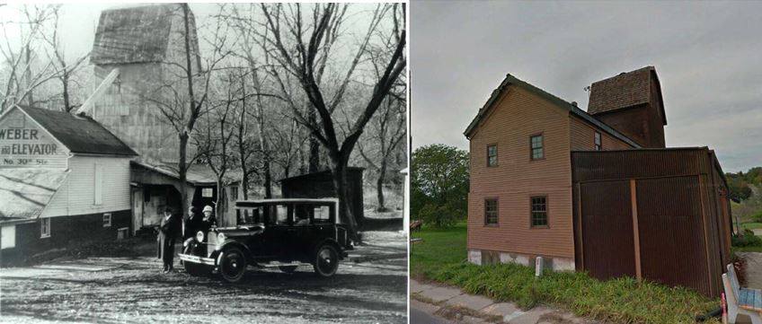
When spring broke open, almost all of the Mormons packed up and left town. A few were left though, and they left their buildings behind. Houses, stores, grain storage, and a few other buildings stood there for years, some in use, many vacant. The last remnant standing today is the Florence Mill, located where Mill Creek once flowed freely to the Missouri River. For reference, the mill was located on the west side of Winter Quarters.
Founding Florence

James Comly Mitchell was an adventurer. After an early life as a traveler, Mitchell brought his English bride to Iowa, but didn’t settle down well. Looking for a chance to make some money, In 1850 his fellow adventurer Peter Sarpy told him about the deserted Winter Quarters across the river from Kanesville, Iowa.
Immediately after the Nebraska Territory was established in 1854, Mitchell platted the village of Florence. He laid it out on the old map of Winter Quarters, and included its old buildings and improvements. As the first city in the Nebraska Territory. Despite lasting only two years, Winter Quarters had many accoutrements of a well-established place, and Mitchell knew it.
He snatched it up quick, started lobbying hard to make Florence the capital of the Nebraska Territory, and dreamed of the railroad building a major bridge across the Missouri River at his town.
It was a few years before a lot of people moved into Florence. Mitchell kept pushing for his town through the years, serving as a Nebraska Territorial Legislator, and working as a saloon owner, ferry owner, and editor of the town newspaper.

Stealing the Legislature
In 1858, a group of legislators illegally tried to hold legislative proceedings in Florence in a tiff over the location of the future state capitol. They lost their hold on power for the day, and everything moved back to Omaha the next day. In 1867, the Omaha resistors in the Legislature finally got their wishes when the brand new Nebraska State Capitol was assigned to be in Lincoln. Its stayed there ever since.
Sucked in by Omaha

Over the next 60 years, Florence failed to amount to much beyond a small town. Nearby small towns like Saratoga, Fort Calhoun, and Elk City struggled too. In 1917, Omaha came gunning. That year, the Town of Florence was annexed by the City of Omaha.
That same year, the Fort Omaha Balloon School was established as the first such military school in America. Its base of operations was called Florence Field and consisted of 119 acres.

Historical Sites
The newest feature in Florence was built in 2001, and is called the Winter Quarters Nebraska Temple. Since 1952, the Mormon Pioneer Memorial Bridge has carried Interstate 680 over the Missouri River. Opened as a single span, there was just a single lane going east and a single lane going west. The State of Nebraska and the State of Iowa agreed to build the bridge with a toll to cover the costs of construction. When they were paid, the Mormon Bridge Tollhouse was removed – although it’s still standing today. Moved to 3010 Willit Street, today the building is home to a hairstylist.
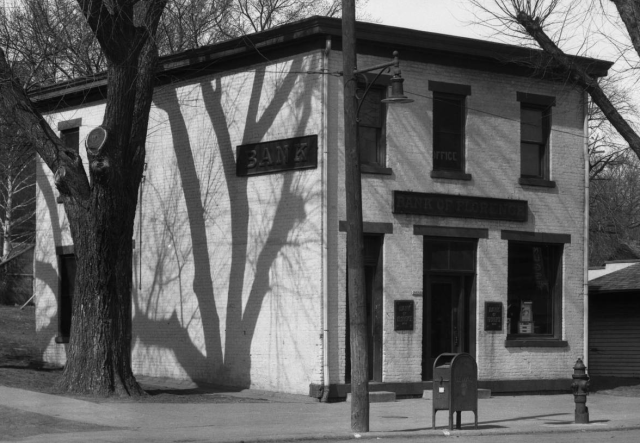
The Bank of Florence was built in 1856 at 8502 North 30th Street. Designated as an Omaha landmark on October 14, 1980, it was placed on the National Register of Historic Places (NRHP) in 1960. The Florence Boulevard was designed in 1892 and built from Burt Street north to J.J. Pershing Drive just outside Florence. Part of a massive citywide boulevard system, the section near Florence was once called the “Prettiest Mile.”
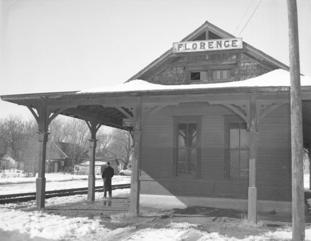
Built in 1887, the Florence Depot was moved to 9000 North 30th Street in the 1960s. The Florence Firehouse, built in 1888, is next to the Florence City Hall and Jail, all at 8415 North 29th Street. Florence Park, located at 3105 State Street, was part of the original Winter Quarters plat map from 1846. It is Nebraska’s oldest park and town square.
One of the most distinct landmarks in Florence today is the Florence Mill. Originally built by Brigham Young in 1846, it sits at 9102 North 30th Street along the former Mill Creek. Listed on the NRHP in 1998, it is also known as the Weber Mill, Mormon Mill, Grist Mill, and Old Pink Mill.
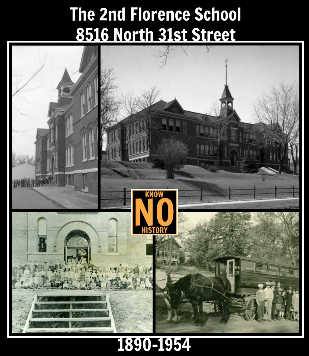
The site of the Florence School has moved several times. In the 1860s it was located down in town, reportedly in an old wood shed. From 1890 through 1964, it was located at North 31st and Tucker Streets. That year, it opened in a new building at 7902 North 36th Street where its located today. For more than three decades this was also the location of the Florence High School.
The Keirle House was built for a local ice company manager in 1905 at 3017 Mormon Street. After housing a youth-focused nonprofit for a number of years, it was sold to a private individual in the 2000s. It was declared an Omaha Landmark in 1997. The Mitchell House was built in 1854 at 8315 North 31st Street by James C. Mitchell himself, and was demolished in the 1970s. Some people think that Brigham Young lived in there for a short period.

Other historical homes are scattered throughout Florence. The Wright House at 7623 North 31st Street is one example. Despite being largely covered today with Mid-century vinyl siding and aluminum storm windows, its Victorian-era opulence plainly obvious in the details still abounding the home.

The Mormon Pioneer Cemetery, home to the hundreds of people who died in the winter of 1846, is located today at 3301 State Street. Used until 1848, LDS Church records indicate 359 pioneers are buried there. In a different location, Omaha’s Potter’s Field Cemetery was started in at least the 1870s, although there’s speculation that the first burials there happened when it was next to Cutler’s Park. Today, its located at 7909 Mormon Bridge Road next to the Forest Lawn Memorial Park.
The earliest businesses in Nebraska happened in the Florence area. Starting in 1805, a fur trader named Manuel Lisa kept a fort north of present-day Florence, and enjoyed exclusive and successful relationships with many area tribes. He died in 1820 and Fort Lisa was closed. In the late 1810s, a Frenchman named John Pierre Cabànne opened a trading post at the confluence of the Ponca Creek and Missouri River, operating it through the 1820s. He hosted a German prince during his years there. Today, there are markers celebrating these mens’ contributions near the intersection of Ponca Road and J. J. Pershing Drive.
Located north of Florence near the intersection of Oakridge Drive and J. J. Pershing Drive, the site of Pries Lake once hosted a saloon, a seven-story house and picnic facilities for families and others to enjoy. It was open from around 1890 through 1915.

The Notre Dame Academy and Convent was built in 1924 to house nuns that came to serve Omaha’s Czech community. The building, located at 3501 State Street, was added to the NRHP in 1998. The Convent was closed in the 1990s, and continues to be operated by the Sisters today as a retirement center. The Florence Home for the Aged, originally called the House of Hope, was built in 1917 at 7915 North 30th Street. That facility expanded, changed and today is still operating at the same location.
Florence Horse Thieves Murdered By a Florence Mob

Another site associated with Florence is the site of a terroristic mob murder. In 1858, a farmer in Florence said he kept having horses stolen. Catching the thieves in the act, he called together a group of neighbors and chased them down just north of Florence. The two, named Harvey Braden and James Daley, were dragged by the men to Omaha and presented them to the judge there, who immediately threw them in jail to wait for a trial.
That evening, a group of dozens showed up at the jail with ropes. Pushing past the sheriff, they opened the jail with his keys and tied the ropes around the mens’ necks. Thrown into the back of a wagon, they were led to the spot two miles north of Florence where the farmer took them hostage earlier that day. Using the wagon they were brought on, the men were strung up and hung.
The sheriff rode up to Florence and got the bodies the next day. When the judge called the men of Omaha to the courthouse that day, he asked them who did it. Nobody admitted any fault, and nobody would say who else was involved. Nobody was ever accused, tried, or convicted for murdering the two men. Later, the truth came out that many of Omaha’s leading men from its pioneer days were involved in the lynching.

River Road

In the early 1890s, the City of Omaha hired a nationally renowned landscape architect named H. W. S. Cleveland to design a system of parks and boulevards throughout the city. They wanted to raise the image of the city as being pro-outdoors while providing simple, straight-forward recreation that would appeal to all citizens. Cleveland’s plans were responsible for the construction of Miller, Fontenelle and Hanscom Parks almost immediately, along with several smaller parks and all of the city’s elaborate boulevard system.
In the late 1910s, private car ownership appeared inevitable for all families in Omaha. In order to accommodate these drivers auto-ing throughout town, the City wanted to expand the boulevard system. They developed a plan for a grand 19-mile-long boulevard that would stretch and wind from South Omaha through downtown across North Omaha to the Ponca Hills. Called River Drive, it would serve as a memorial to the city’s fallen from World War I, and promote a shared sense of ownership for the natural beauty of the Missouri River.
Alas, the plans never came to fruition. However, in Florence a large section of the road was constructed. Beginning at the end of Florence Boulevard and Reed Street, the River Drive was graded and paved all the way to Ponca Road. In the 1920s, this section was renamed John J. Pershing Drive, and its usage continues today.
Florence Historical Tour
These are places I think are interesting in Florence. Don’t try to follow them in order – they’re numbered here for easy reference, and that’s it. Let me know if there’s more I should check out!
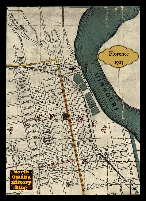
- Florence Mill, 9102 North 30th Street
- Florence Depot, 9000 North 30th Street
- Zesto’s, 8608 North 30th Street
- Bank of Florence, 8502 North 30th Street
- Mormon Bridge, crossing the Missouri River on I-680
- Mormon Bridge Tollhouse, 3010 Willit Street
- Florence Masonic Temple, 8223 North 30th Street
- Florence Building, 8702 North 30th Street
- Price Building, 8607 North 30th Street
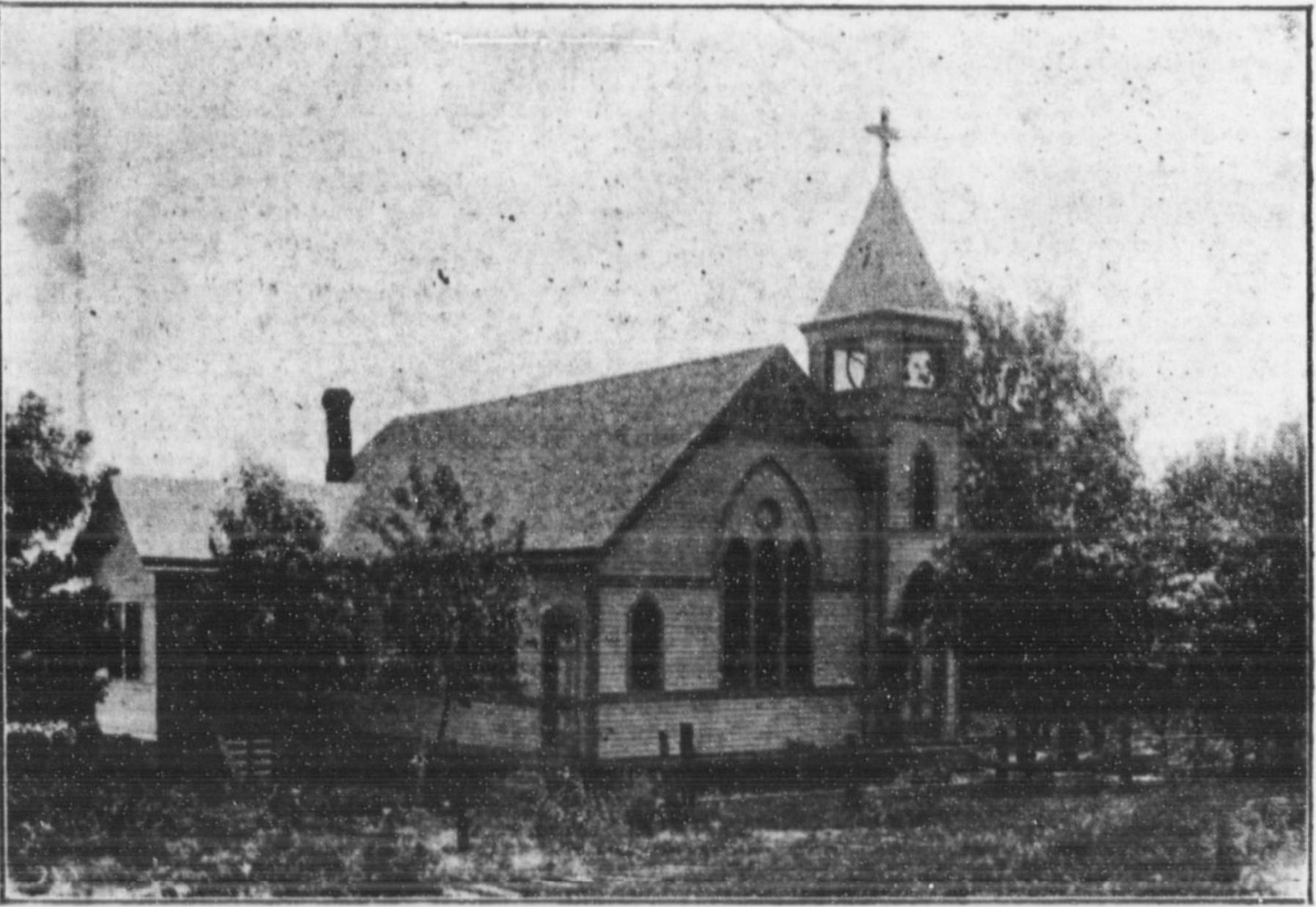
- St. Philip Neri Church, 8200 North 30th Street
- St. Philip Neri School, (original site) 8206 North 31st Street
- Florence Home, 7915 North 30th Street
- Florence School, 7902 North 36th Street
- Florence Firehouse, 8415 North 29th Street
- Keirle House, 3017 Mormon Street
- Mormon Trail / Winter Quarters Visitors Center, 8283 North 34th Street
- Notre Dame Academy and Convent, 3501 State Street
- Potter’s Field, 5000 Young Street
- Forest Lawn Cemetery, 7909 Mormon Bridge Road
- Florence Water Works, John J. Pershing Drive
- Florence Home for the Elderly, 7915 North 30 Street
- J. S. Paul Building, 8601 North 30 Street
- Mormon Pioneer Cemetery and Statue, 3301 State Street
- Price Building, 8607 1/2 North 30 Street
- Price House, 3119 Clay Street
- Florence Town Square, aka Florence Park, 3105 State Street
- River Drive, from Florence Boulevard to Ponca Road
- Wright House, 7623 North 31st Street
- North Market Square, aka Filmore Park, North 29th and Bondesson Streets
- South Market Square, aka houses, North 29th and King Streets
- Mormon Reserve, underneath the Mormon Bridge between J.J. Pershing Dr. and the river
- Ferry Reserve, north of Mormon Bridge between J.J. Pershing Dr. and the river
- J. J. Pershing Memorial Monument, near 8200 J.J. Pershing Drive
- Pries Lake, near Oak Ridge Drive and J.J. Pershing Drive.
- Joyo Theatre, N. 30th and Tucker Streets

Historic Streets

The streets of Florence marked the city limits throughout the years, and the boundaries of of the city were mostly steady throughout the years. When it was annexed in 1917, the boundaries were Weber Street on the south and Sargent Street to the north; Missouri River on the east and North 60th Street on the west.
Florence is old, and because of that it had streets that aren’t around anymore, or that have been renamed.
For instance, streets running east-west in the historic city of Florence that were north of Mill Creek included Parker, Downey, Sargent, Cook, Ferry, Davenport and Bridge. South of the creek, east-west streets included Pacific, Jackson, Fillmore, Calhoun, Clay, Jefferson, Wilit, State, Madison, Harrison, Monroe, Adams, Farnum, Washington and Briggs. Spring Creek bisected the town on the south end, and Hanover, Taylor, Scott, and Spring Street ran east-west there.
Running north-south, the streets in old Florence were named and numbered, but with different numbers than today. Starting at the Missouri River and going west, the streets were Mill, 1st, 2nd, 3rd, 4th, 5th, then Main, Bluff, Prospect, Buffalo, and Elk.
Thanks to all the people who contributed to this article’s development, including Ryan Roenfeld, Roger Brandt, Michaela Armetta, Michele Wyman, Jody Lovallo and John Lemen for their contributions to this article. Also, special thanks to the Durham Museum for making so many pics available, and to the Florence Futures Foundation for their fantastic website and work to preserve Florence history!
You Might Like…
MY ARTICLES ABOUT THE HISTORY OF FLORENCE
Public Places: Florence Main Street | Florence Ferry | Florence High School | The Mormon Tree | Florence Water Works | Mormon Bridge | Florence Boulevard | River Drive | J.J. Pershing Drive and Monument | Potter’s Field
Businesses: Bank of Florence | Florence Mill | Zesto
Houses: Parker Mansion | Brandeis Country Home | Lantry-Thompson Mansion | Mitchell House | Hunt Mansion
Other Historic Places: Vennelyst Park | Florence Depot | Florence Home | Florence Building
People: James M. Parker | James Comey Mitchell | Florence Kilborn
Neighborhoods: Winter Quarters | Florence Field | Wyman Heights | High Point
Other: Directory of Florence Historic Places
MY ARTICLES ABOUT HISTORIC NEIGHBORHOODS IN NORTH OMAHA
National Register of Historic Places Historic Districts in North Omaha: 24th and Lake Historic District | Benson Downtown Historic District | Country Club Historic District | Dundee/Happy Hollow Historic District | Fairacres Historic District | Fort Omaha Historic District | Minne Lusa Historic District | Nicholas Street Historic District
Historic Neighborhoods in North Omaha: Bedford Place | Belvedere Point | Bemis Park | Benson | Briggs | Bungalow City | Carter Lake, Iowa | Central Park | Clifton Hill | Collier Place | Creighton University | Crown Point | DeBolt | Druid Hill | East Omaha | Fairfax | Florence | Florence Field | Fort Omaha | Fontenelle View | Gifford Park | Gold Coast (Cathedral) | High Point | Jefferson Square | Kellom Heights | Kountze Place | Lakewood Gardens | Little Russia | Long School | Malcolm X Memorial | Miller Park | Miller Park Duplex Historic District | Monmouth Park | Montclair | Near North Side | North Downtown Omaha | Omaha View | Orchard Hill | Plum Nelly | Prettiest Mile in Omaha | Prospect Place | Raven Oaks | Redman | Saratoga | Sherman | Squatter’s Row | Sulphur Springs | Ponca Hills | Wakonda | Walnut Hill | Winspear Triangle | Wyman Heights
Lost Towns in North Omaha: Benson | Briggs | DeBolt | East Omaha | Florence | Saratoga | Sulphur Springs
Bonus Pics!


Leave a comment